
Mild air surges into Atlantic Canada as active storm track locked in

An active storm track will remain locked over Atlantic Canada during this first week of January, with back-to-back storms threatening more heavy snow, rain, ice and powerful winds.
With heavy snow coming to an end in Newfoundland soon, there won't be much of a reprieve for the island, or the Maritimes, come Wednesday and beyond. An active storm track will bring in at least two more systems before the weekend arrives, with Wednesday's messy and windy system serving as an appetizer for what could meet the requirements of a bomb cyclone on Friday. The exact track is still highly uncertain, but it could bring heavy shots of snow, as well as ice pellets, freezing rain and powerful winds. More on the next two entrants in the ongoing storm parade that is marching through Atlantic Canada through the start of January, below.
WEDNESDAY: SNOW TAPERS IN NEWFOUNDLAND, MILDER AIR RETURNS WITH AN ACTIVE PATTERN
Conditions will improve in southern Newfoundland in the overnight hours Tuesday, but there will be sea-effect snow on the northern coast on the backside of the low into Wednesday morning. But it won't be tranquil for long as the next system is in line for impact.
Temperatures will warm up again on Wednesday as a milder pattern returns to Atlantic Canada. Wednesday’s highs are set to climb above freezing everywhere but northern New Brunswick and much of Newfoundland. Readings will flip to above-seasonal levels in Nova Scotia, where Halifax will see a high of 6°C on Wednesday and a relatively balmy 8°C on Thursday.
In addition to the warm-up, there is another potent system right on the heels of Tuesday's storm. The setup involves a snowy Alberta clipper and a mild Atlantic low-pressure system, moving into the Maritimes Wednesday afternoon.
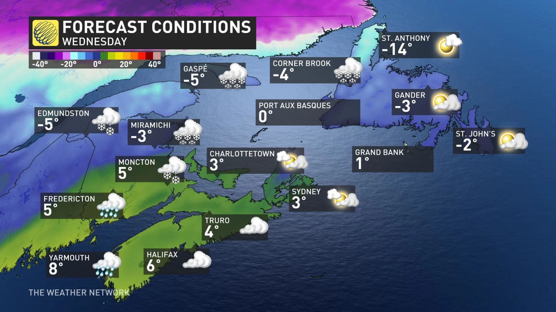
It will bring heavy rain for Nova Scotia and much of New Brunswick and P.E.I. in the afternoon and evening, and snow for northern New Brunswick with freezing precipitation in central areas of the latter.
Rain, at times heavy, is expected to develop over western and southwestern Newfoundland Wednesday overnight before spreading across the rest of the island on Thursday. The rain will combine with above freezing temperatures to cause significant snowmelt and possible localized flooding. Special weather statements are in place.
As well, winds will be strong for the Maritimes and Newfoundland Wednesday afternoon and evening, with gusts of 40-70 km/h.
The warmer temperatures will continue through the end of the week before chillier weather returns.
FRIDAY: EYES ON A NOR'EASTER THAT THREATENS MORE HEAVY SNOW
Beyond, another potent storm awaits for the end of the week. A nor’easter for Atlantic Canada will move in Friday afternoon and continue into Saturday morning. The large and strong low pressure will rapidly intensify as it tracks into the region -- with the potential to exceed the requirements for a bomb cyclone.
The exact storm track is still uncertain. However, at this point it looks like the track will be across or just south of Nova Scotia, and then into central Newfoundland.
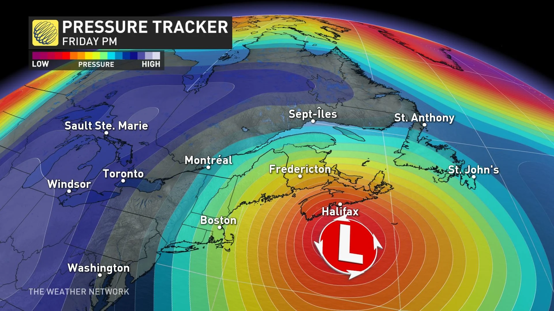
This would bring heavy snow to New Brunswick, northern Nova Scotia, P.E.I., and western Newfoundland with parts of this region seeing 20-40+ cm. Blizzard conditions are possible for P.E.I., eastern New Brunswick and western Newfoundland with wind gusts of 70-100 km/h.
"Highly uncertain forecast for Halifax. The exact storm track will be critical to whether Halifax is included in the swath of 20-40 cm of snow versus a messy mix of snow, ice and rain. A messy system for eastern Newfoundland including St. John’s with snow, ice, and rain," says Dr. Doug Gillham, a meteorologist at The Weather Network.
Check back for the latest on conditions with the active storm track across Atlantic Canada