Blizzard conditions, dangerous travel expected to kick off Thanksgiving weekend

Snowfall totals could reach 60+cm in southwestern Manitoba
It won't be a pleasant way to end the work week and kick off the Thanksgiving weekend for those in Manitoba and northwestern Ontario, as a significant storm takes aim at the provinces beginning Thursday. Special weather statements are already in place, prior to the potent stateside system that could drop more than 20 cm of snow over parts of southern Manitoba and upwards of 75 mm of rain in northwestern Ontario. We have the timing of this storm, and when and where to expect the worst travel conditions, below.
Based on the current forecast, southeastern Manitoba could receive over 50 mm of rain with the same system, something these areas do not need. Local states of emergency have been issued for some communities due to an abundance of rainfall to area over the last few months.
Visit our Complete Guide to Fall 2019 for an in-depth look at the Fall Forecast, tips to plan for it and a sneak peek at the winter ahead
WATCH BELOW: WHEN TO EXPECT HEAVY SNOW, STRONG WINDS IN MANITOBA
After Alberta received a shot of heavy snow earlier this week, Manitoba is next in line for a signficant dumping of the white stuff. A potent system will move in beginning Thursday, threatening heavy snow and treacherous travel. It is expected to continue through the early part of the Thanksgiving long weekend.
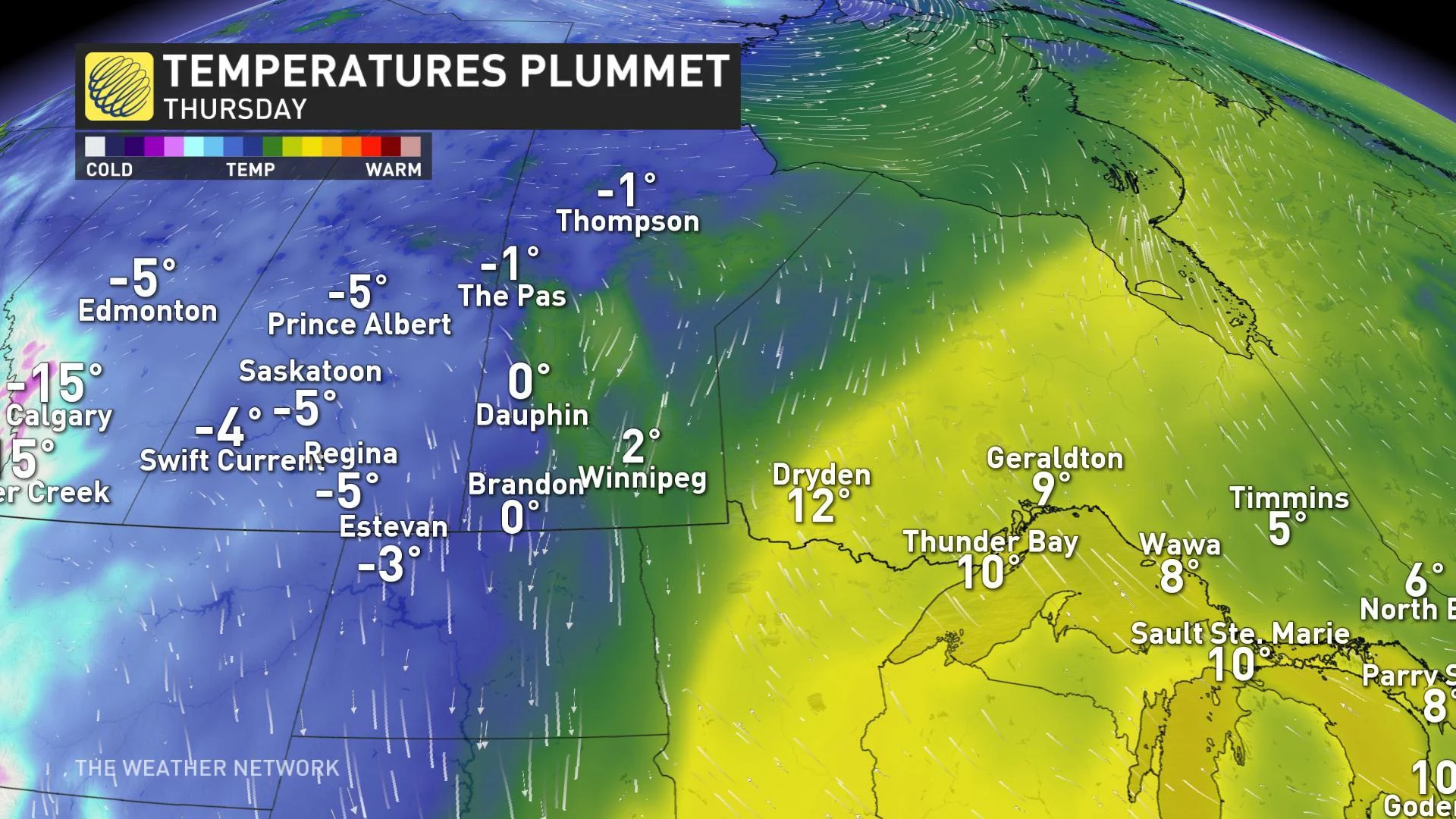
"High impact snowstorm/blizzard begins Thursday and peaks Friday and Friday night (ending Saturday) for a large part of southern Manitoba (especially between Winnipeg and Brandon) and the U.S. Upper Midwest," says Weather Network meteorologist Dr. Doug Gillham.
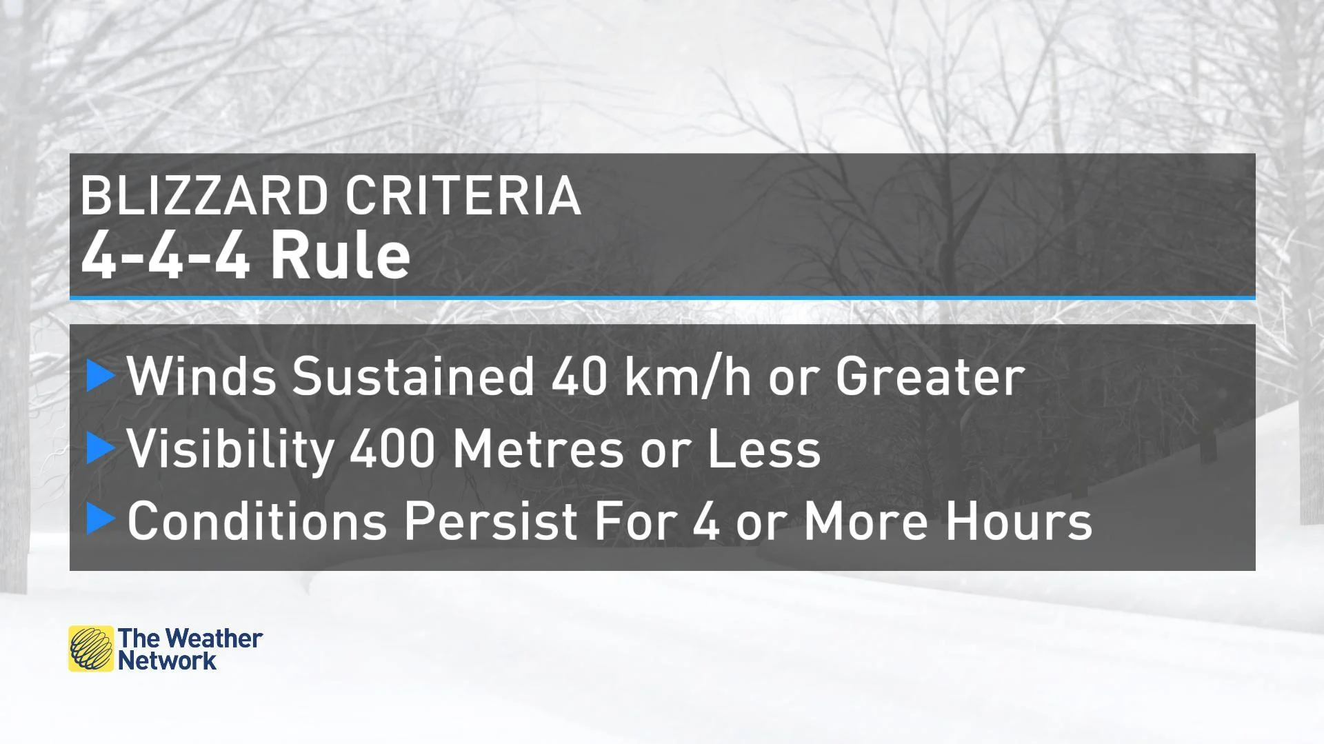
"Widespread blizzard conditions with severe impacts to transportation and agriculture. Concerned about tree damage and power outages as the foliage is still on the trees and heavy, wind-driven wet snow is expected."

Because temperatures will be very marginal –- near or just above freezing --a wide range in accumulations are likely with elevation having a significant impact. Snowfall totals of 20 to 40 cm are expected for much of the region, while some southwestern areas could see 60 cm or more.
"This storm will bring blizzard conditions with sustained winds reaching 50 km/h, with gusts of 80+ km/h. Travel will be extremely dangerous to impossible during the height of the storm," said Gillham.
Totals for Winnipeg will be "extremely difficult" to forecast, as there is a significant bust potential since the city is right on the sharp edge of where the heaviest snow will fall, Gillham added. There is higher confidence in snowfall totals in communities west of Winnipeg.

Conditions will improve in Manitoba Saturday, but winds will remain gusty at times. At this point, Sunday will be the most ideal day to travel as quieter weather moves in.
STORM TO BRING HEAVY RAIN, STRONG WINDS TO NORTHWESTERN ONTARIO
While Manitoba is expected to receive a hefty amount of snow, areas in northwestern Ontario will get heavy rain because of the temperature contrast between the two provinces. Through Saturday, strong winds and between 50 to 75 mm of rain is forecasted for areas around Lake of the Woods.

While the weather will remain unsettled in northwestern Ontario until after the Thanksgiving long weekend, Sunday will be the best day to travel.
Stay tuned to The Weather Network for the latest updates on the storm.