Labrador just outsnowed YEARLY totals for many major Canadian cities

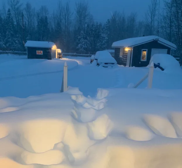
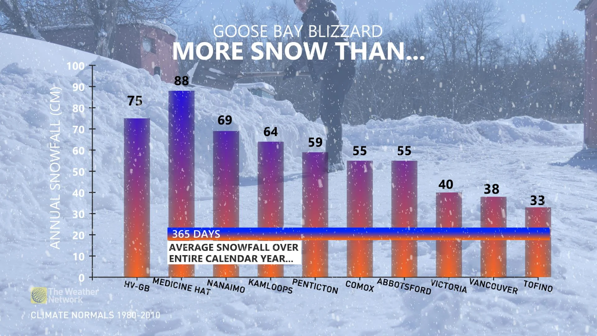
After picking up 75 cm of snow from just one potent storm, Happy Valley-Goose Bay has now officially outsnowed several major Canadian cities' annual snowfall totals.
Perspective: What fell in a matter of hours for the small town located in the central part of Labrador is actually more snow than what somewhere like Nanaimo, British Columbia would see in an entire year.
While the 75 cm wasn't quite enough to top the notoriously snowy city of Medicine Hat, Alberta, the average of 88 cm recorded there is what typically falls over a 365-day timeframe -- not in less than 48 hours, which is what Happy Valley-Goose Bay just endured.
It's an historic early season snowfall for the books.
This record-breaking storm rapidly intensified as it tracked through the northern Gulf of St. Lawrence Monday night, crossing southern Labrador on Tuesday and prompting widespread winter warnings for central sections of the region. The heavy snow combined with powerful northerly winds with gusts up to 80 km/h made for treacherous travel conditions and near zero visibility through Tuesday.
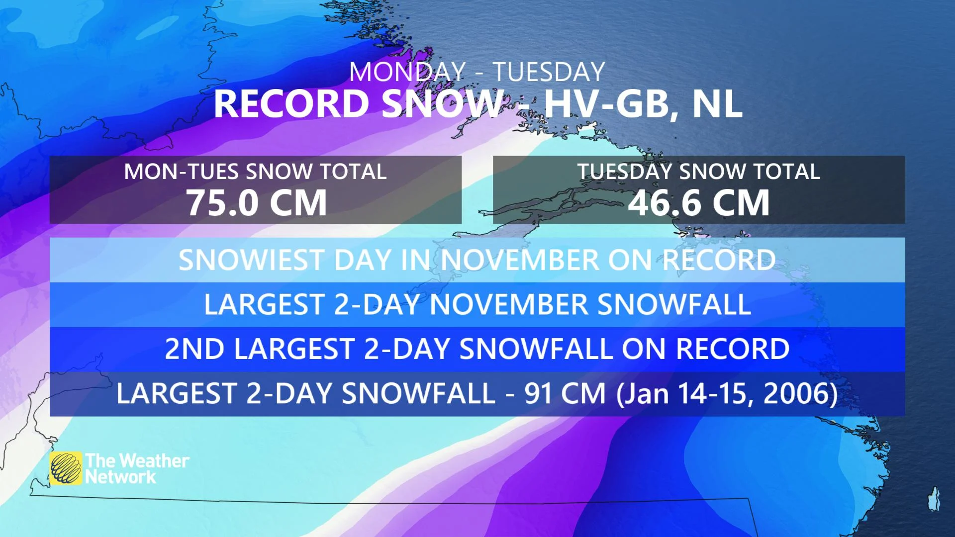
At one point, the snow was falling at an astonishing rate of 5-10 cm per hour, dumping more than 45 cm on Happy Valley-Goose Bay through the day on Tuesday. On Monday, 28.4 cm of snow had already piled up.
These snow totals were enough to break several significant records for the region, including the snowiest day in November history and the largest two-day November snowfall. The record fell short of the highest two-day total of all time, with the 91 cm that fell on January 14-15, 2006 still holding that title.
WERE THESE RECORDS JUST A MATTER OF GETTING LUCKY? (OR UNLUCKY FOR THE NON-SNOW LOVERS)
To set all-time daily records the majority of snow must fall on a single day. Most of the heavier snow in Happy Valley-Goose Bay held off until late Monday evening and Tuesday morning, allowing the daily record to be surpassed.
"The result was an intensifying low-pressure system tracking just south of the town, the absolute perfect track to maximize snowfall potential and squeeze every last snowflake out of the atmosphere," says Weather Network meteorologist Tyler Hamilton.
While strong lows of this intensity pummel Labrador all the time, in this particular case, an organized deformation zone developed, creating a region of heavier snowfall just south of Lake Melville.
"A strong jet stream aloft provided added support in the atmosphere, further strengthening the low. The moisture content of the low was then boosted by a bountiful moisture source drawn up from the Atlantic Ocean," Hamilton adds.
MUST SEE PHOTOS: Labrador buried under historic 75 cm of snow
WATCH: OVER 70 CM OF SNOW BRINGS HARSH DOSE OF EARLY WINTER TO LABRADOR
Thumbnail image courtesy: Denise Earle