
Unrelenting heavy rain in Newfoundland may bring localized flooding

When it rains, it pours, and it certainly has done that in Newfoundland this weekend. In fact, it will continue into early next week, thanks to a blocking pattern in the North Atlantic forcing lows to stall over the region. The eastern coastal region of the island could see anywhere from 30-75+ mm of rain, depending on location, through Tuesday morning. Winds will also be blustery across Newfoundland through Monday. Rainfall warnings are in place across parts of the island. See below for more details on the timing and impacts expected.
SUNDAY: UNSETTLED AND COOL IN ATLANTIC CANADA
Precipitation will be mainly rain Sunday across Newfoundland as the system continues to retrograde over the island. Rain, at times heavy, will ease in the overnight period, but is expected to begin again Monday morning and continue until Tuesday.
Rainfall warnings are still in effect, with Environment Canada warning of possible localized flooding in low-lying areas. "Don't approach washouts near rivers, creeks and culverts," the agency says in the warning.
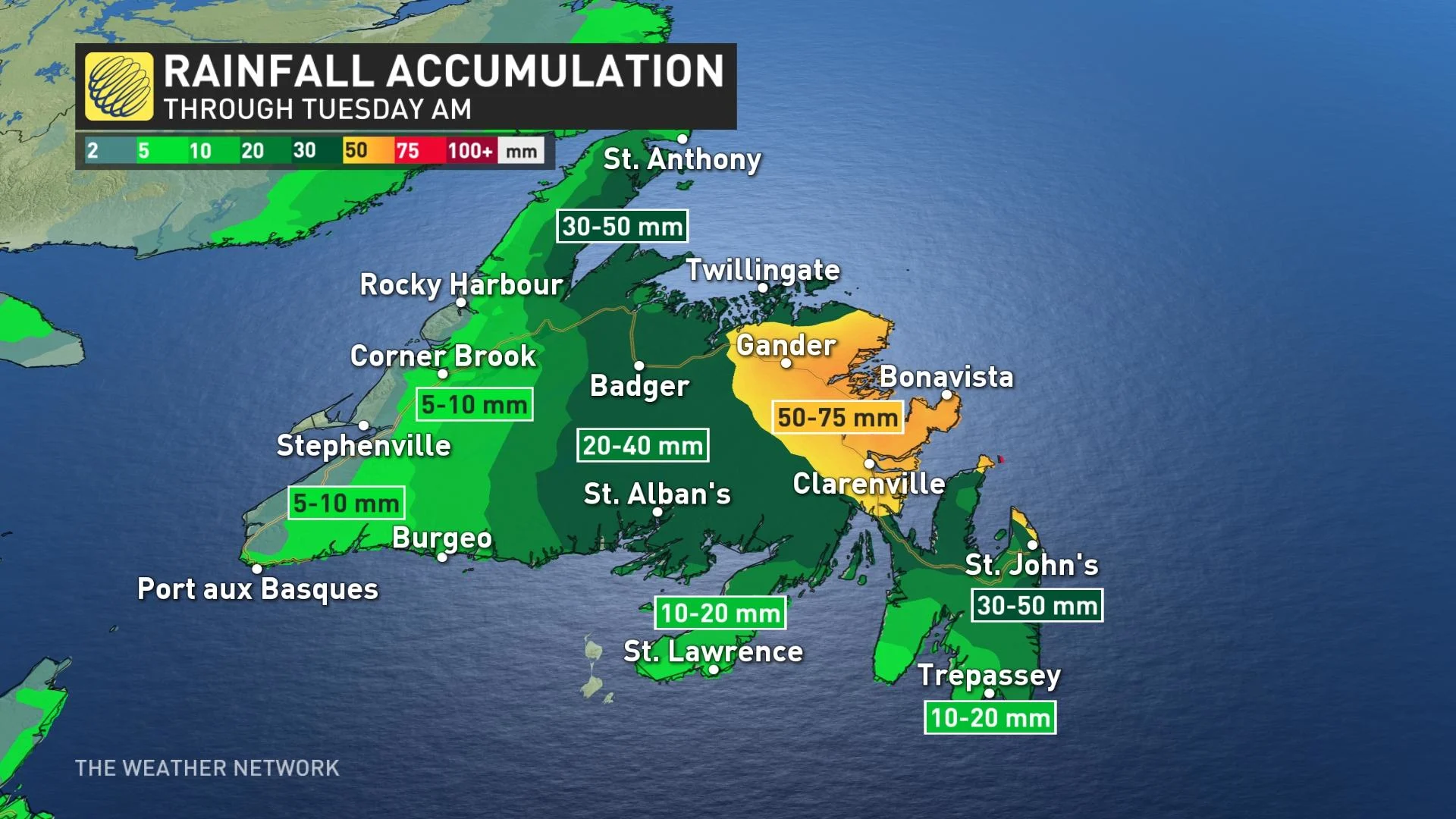
Amounts will be heaviest along the entire eastern coastal section of the island, where accumulative amounts may vary from 30-75 mm. St. John's could even see 75+ mm of rain through Tuesday. The city already recorded 42.8 mm Saturday and an additional 40 mm is possible.
Meanwhile, spotty showers will continue to push west across the region in the overnight period, reaching the Maritimes as the system maintains its westward track.
Winds will intensify across Newfoundland once more, with gusts hitting the 50-70 km/h range along the coastal regions in the afternoon hours.
MONDAY AND BEYOND: WET AND COOLING OFF AS PATTERN CHANGE
Atlantic Canada will continue to see active weather into Monday as the upper low lingers and additional waves of moisture track through the region. In Newfoundland, rain will return in the morning and persist until Tuesday.
The retrograding system will also continue to impact parts of the Maritimes with passing showers, even snow showers, late Monday night into early Tuesday morning.
As well, the winds will be somewhat blustery in the Maritimes, with 40-50 km/h gusts, but will be stronger in Newfoundland -- 60-80 km/h range in the afternoon.
Heading into the third week of April will also see cooler than seasonal temperatures will spread into the Maritimes at times, while Newfoundland should be near seasonal.
Check back as we continue to monitor the forecast for Atlantic Canada this weekend and beyond.