Checking in on the strange stats of Canada's 2019 tornadoes
Summer 2019 took a long time to hit its stride across much of Canada, and when it comes to severe weather stats, it's still lagging behind for most -- with a few notable exceptions.
As of July 26, 42 tornadoes have been reported across the country, which is a decent 68 per cent of the yearly average, but a lot of that high score is thanks to one province.
Summer revealed! Visit our Complete Guide to Summer 2019 for an in-depth look at the Summer Forecast, tips to plan for it and much more
Alberta is leading the pack with 19 unofficial twisters on the books; that's 4 more than they see in a typical year overall, putting the province at 123 per cent of their yearly average. Saskatchewan is also pulling their weight when it comes to tornadic storms, with 13 suspected tornadoes thus far in 2019. The province typically sees about 18 tornadoes in a year.
Northern Canada also helped give the country's total a boost, with one tornado confirmed in the Northwest Territories in early June. Since there have been only a handful of confirmed tornadoes in the history of the territories, it's fair to say this storm was 'rare'.
Eastern Canada, however, is falling behind when it comes to strong storms. Only 4 tornadoes have been reported in tornado-prone Ontario so far, and just 1 in Quebec -- 32 and 21 per cent, respectively, of their yearly averages.
RELATED: Northern Tornadoes Project seeks every twister in Canada in 2019
WHAT'S BEHIND THIS YEAR'S UNUSUAL STATS?
While a lot of local-level effects needs to come together to spawn tornadoes, the large-scale pattern can give us a piece of the puzzle when it comes to explaining this year's unusual statistics.
One of the drivers for this summer's lacklustre temperature performance in the east and unusual-raininess in B.C. is the mean position of the jet stream. We can get a feeling for the position of the jet stream across the continent via the map below, which shows the average position for the strongest winds at the 500 millibar level (about 5500 metres above the surface) in June and July.
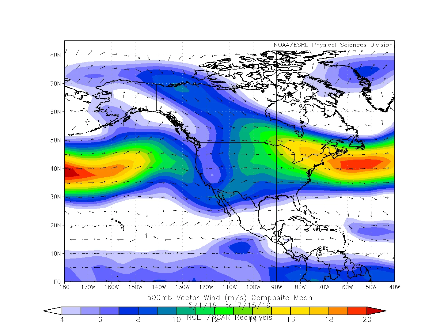
The mean position of winds at 500 mb over North America in June and July 2019. Image courtesy ESRL/NOAA.
Note the dips in the winds over B.C. and, broadly, over Quebec and the Maritimes. While they're washed out a bit by the fact this is a map of the average position, it does give us a feeling for the 'troughiness' that both coasts have seen a lot of this summer; that is, the dips in the jet stream over the regions that have kept temperatures cooler and the weather more unsettled with days of showery rain.
Sitting in a trough in the jet stream also isn't a great position when it comes to supporting really strong individual storm cells -- the ones that forecasters watch for their tornadic potential.
Contrast that with Alberta, which has frequently been on the leading edge of a ridge in the jet over the Prairies. With stronger winds positioned overhead, the province has repeatedly been in the crosshairs for stronger storms this summer.
With files from Weather Network meteorologist Matt Grinter. Sources: Northern Tornadoes Project |