Ontario: What's ahead after powerful winter impact?

Wednesday as an ordeal for travellers, but the rest of the week is looking kinder
After an impressively snowy Wednesday, the latest winter wallop is largely done with southern Ontario. Calmer weather beckons to close out the week, but we're keeping an eye on a bit more snow potential on the weekend. More on that, below.
Visit our Complete Guide to Spring 2019 for an in depth look at the Spring Forecast, tips to plan for it and much more.
WEATHER HIGHLIGHTS:
After snowy Wednesday, calmer skies close out the week
Remaining chilly through Thursday, slightly milder into weekend
Eyes on the potential for a shot of snow over the weekend
AFTER SIGNIFICANT SNOW, CALMER END TO THE WEEK
The system will have largely moved on overnight, leaving behind significant snowfall accumulations that triggered school district closures and school bus cancellations Wednesday morning.
The city of Toronto had already slightly surpassed its entire average annual snowfall by Tuesday, and the 18 cm reported at Pearson airport from this latest event has nudged it even further over over.
WATCH BELOW: TORONTO SURPASSES AVERAGE SNOWFALL FOR THE SEASON
Thursday will feature much calmer skies, and Friday will be fair and seasonal, though the weekend may hold some snow potential.
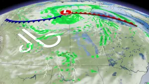
"A few centimetres of snow is possible on Saturday from a weak system," Weather Network meteorologist Dr. Doug Gillham says. "We're closely watching the potential for a Texas Low that will track well south of the border on Sunday – but could track far enough north to impact parts of southern Ontario and southern Quebec. Scenarios still range from a total miss to significant snow with a northeast wind off Lake Ontario. Definitely a system to watch."
Behind this system, Arctic air will flood into the Great Lakes region, dominating next week with temperatures markedly colder than seasonal.
"Colder than normal temperatures are expected to continue into the second week of March," Gillham says. "However, a pattern change is expected as we approach mid-March. An extended period of much milder weather is expected for the second half of March and into early April."
Thumbnail courtesy Dan Timleck, Conestogo, ON.