
Pattern shift signals spring's forthcoming return to Ontario with warm-up

May has not been too kind to southern Ontario thus far, with below seasonal temperatures and periods of unsettled weather, and even some patchy frost here and there. The trend continues Tuesday with some sporadic showers and even the chance of some thunderstorms in eastern sections. However, spring will finally get back on track during the second half of this week, as we finally say goodbye to April-like weather as temperatures climb back to near seasonal, and even warmer by next week. More on Tuesday's showery chance and when temperatures will finally return to seasonal values, below.
TUESDAY THROUGH WEDNESDAY: COOLER, UNSETTLED PATTERN KICKS OFF ANOTHER WEEK
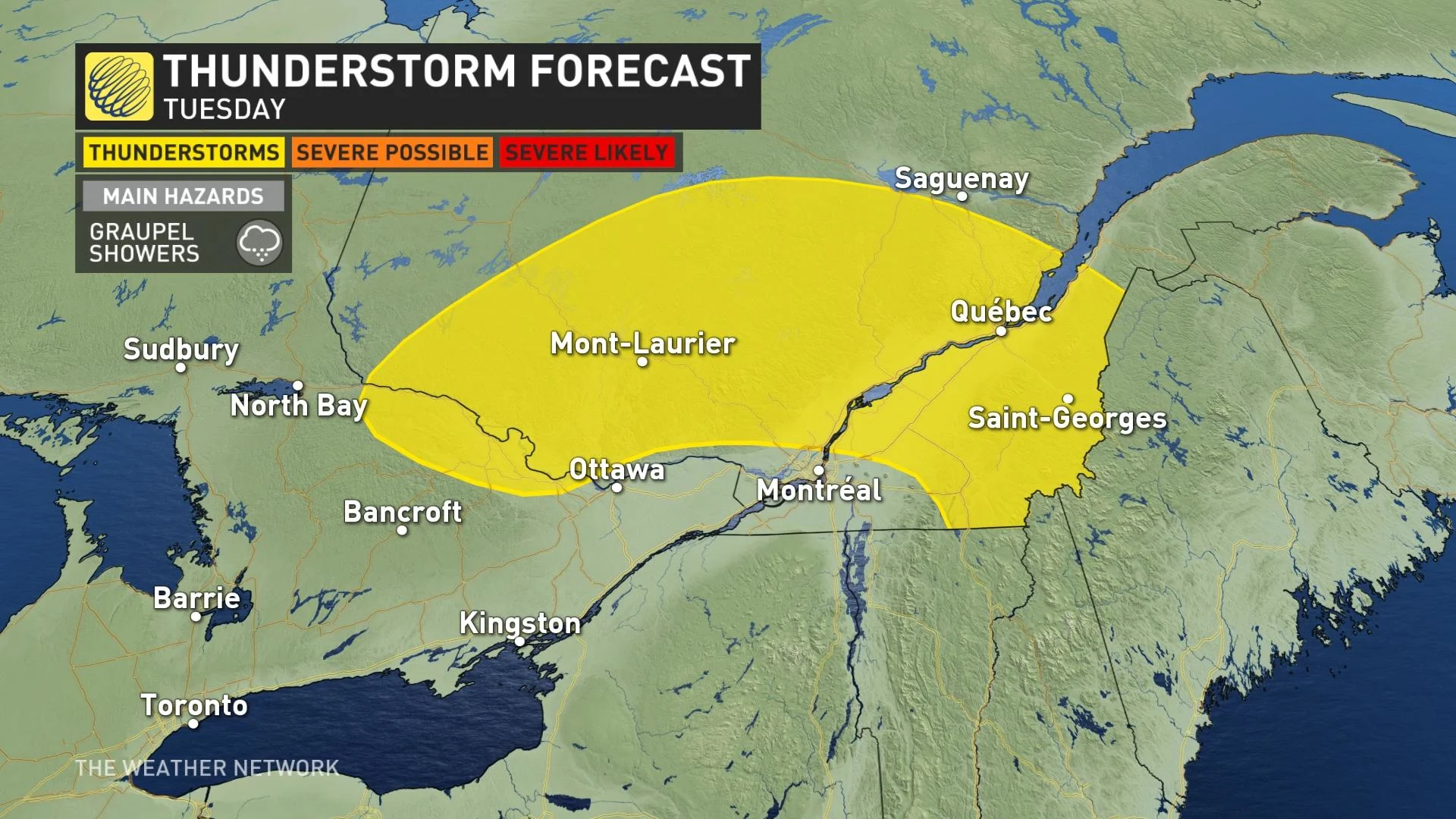
Tuesday will feature a similar setup as Monday, with the cooler weather lingering and the chance for occasional showers, with a thunderstorm risk creeping into eastern Ontario. This is the result of a low sinking south in Quebec and some instability in the atmosphere.
Any storms that do pop up in the afternoon will be non-severe in nature and may feature graupel showers embedded.
MUST SEE: After a strong start in April, spring sputters into May across Canada
"Since Monday May 3, only one day has managed to break the 15 degree mark in southern Ontario, when we reached 15.4°C at Toronto's Pearson Airport on Saturday," says Michael Carter, a meteorologist at The Weather Network. "These temperatures in the low double-digits are well below the normal of 18°C."
A gradual change in the pattern will start on Wednesday, resulting in more sunshine and daytime highs that will begin to climb -- closer to seasonal for this time of year.
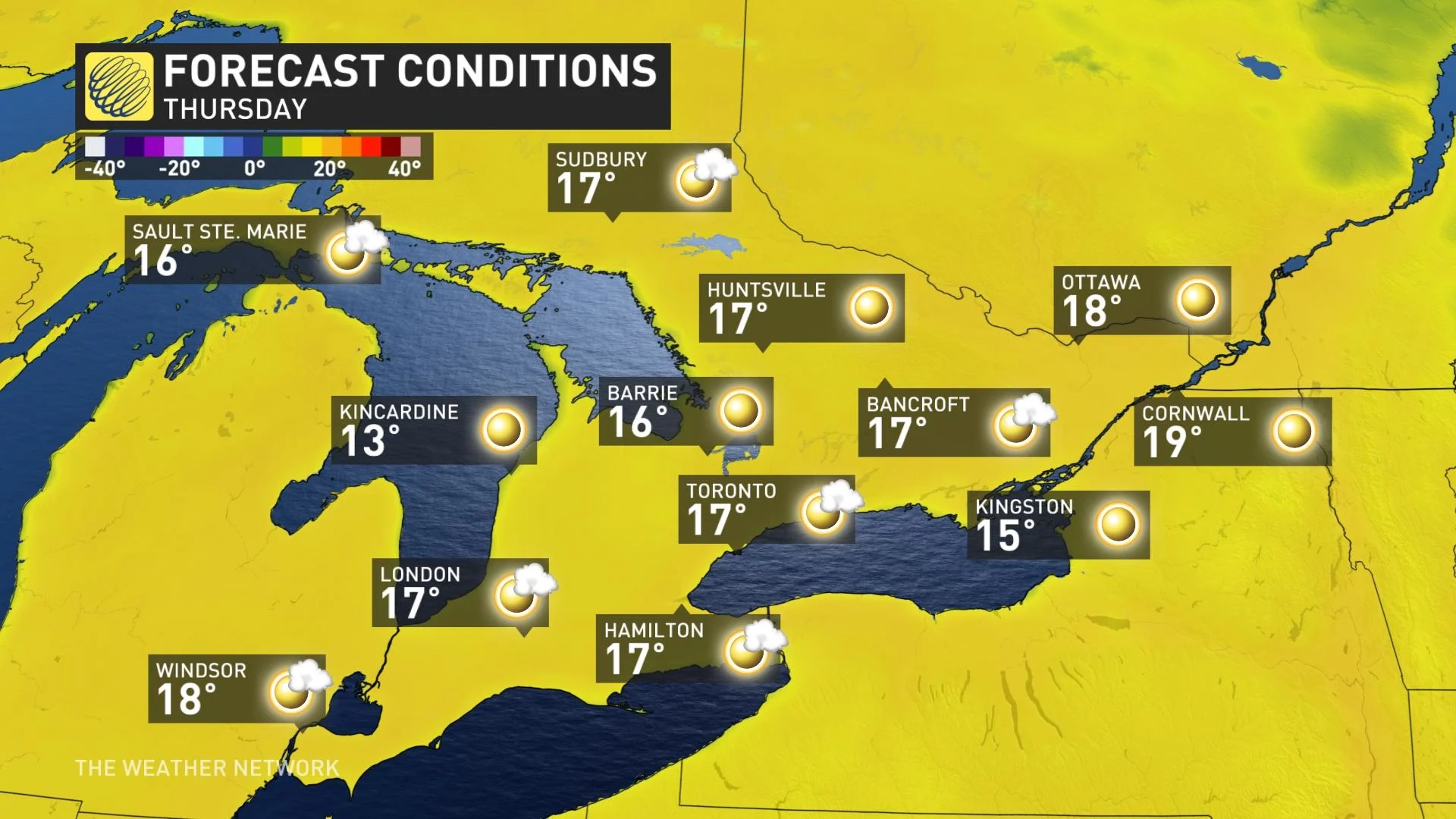
LATE WEEK: TEMPERATURES FINALLY CLIMB TO VALUES MORE TYPICAL OF MID-MAY
The pattern change will begin in Western Canada, as a more zonal flow develops.
"This band of west-to-east winds will open the door for more mild Pacific air to begin to push across the country," Carter says.
Meanwhile, the eastern trough will weaken and move away, causing the chilly temperatures to yield to the milder flow.
By Friday, daytime highs will inch closer to the 20-degree mark across much of the Greater Toronto Area, with the pleasant conditions spreading into the weekend, as well. Scattered, passing showers are likely for southern Ontario in the afternoon, but we will also see periods of sunshine and most of the day the weather will be dry.
On the weekend, some passing showers are possible on Saturday afternoon, but most of it will remain dry.
Warmer weather and abundant sunshine are expected to continue into next week, with an extended stretch of temperatures sitting in the lower 20s region-wide.
The second half of May will be very different from how May has started so far, with temperatures expected to be near seasonal and at times above seasonal for the end of the month.
Be sure to check back for the latest updates on the gradual pattern change across Ontario and the return to more seasonal conditions.