Ontarians should wait out dangerous blizzard at home, major highways close

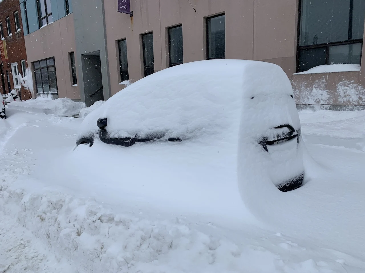
Drivers are being urged to avoid any non-essential travel on Monday, as heavy snow and powerful winds make for treacherous road conditions across Ontario. Although the blizzard warnings dropped across the Greater Toronto Area before noon, winter storm warnings remain, as gusty winds will continue to threaten reduced visibility and potential whiteouts through the afternoon hours. The heavy accumulation is also making for near impossible snow removal and maintenance at times, with Toronto Police officials temporarily shutting down the Don Valley Parkway and Gardiner Expressway. Over 50 cm of snow is forecast in the hardest-hit areas, along with wind gusts between 60-80 km/h into Monday afternoon. Most schools across the province have closed their doors, with school buses pulled from the slick and snow covered roads first thing Monday as well. More on the timing and impacts expected and how quickly the storm moves out, below.
MONDAY: DANGEROUS SNOWFALL RATES LEAD TO TREACHEROUS TRAVEL, SCHOOL AND HIGHWAY CLOSURES RACK UP
A potent low-pressure system that is tracking south of the Great Lakes is bringing in major snowfall and dangerous travel to much of Ontario on Monday.
PHOTOS: WINTER STORM WALLOPS ONTARIO, QUEBEC, DRIVERS SHOVEL ON THE SIDE OF THE HIGHWAY
Winter storm and snowfall warnings are widespread, along with a blizzard warning that remains in effect for parts of eastern Ontario, including the city of Ottawa. Blizzard warnings had covered much of the GTA early Monday as well, but have since been replaced.

"Hazardous blizzard conditions with heavy snow and strong winds are resulting in widespread near zero visibilities," says Environment and Climate Change Canada (ECCC) in the blizzard warning.
Blizzard warnings are issued when widespread reduced visibilities of 400 metres or less are expected for at least four hours.
"If you become stranded in a vehicle do not leave," ECCC adds. "The vehicle offers a form of protection from the cold. A single person walking through the snow is harder to find than a stranded car or truck."
DRIVERS SEEN SHOVELLING OUT HIGHWAY 401, DVP AND GARDINER TEMPORARILY CLOSE
The treacherous conditions are significantly impacting commute times, as blowing snow and reduced visibility on the roads will persist into the afternoon hours as wind gusts pick up.
Traffic was at a complete standstill along many major routes early Monday, including Highway 401, where even snow plows were having a difficult time and drivers were seen shovelling out the roadway.
"The biggest problem right now is the plows are stuck in this as well. If they can't clear the highways, you're not going anywhere, so you should have stayed home," said OPP Sgt. Kerry Schmidt in a tweet urging southern Ontarians to just wait it out at home. "If you haven't left your driveway, don't bother," Schmidt added, "wait for the snow to pass, wait for the plows to clear the highways."
According to Schmidt, dozens of collisions have been reported throughout the GTA, with vehicles spinning out, losing control and getting caught in the snowbanks or ending up in the ditch amid the slick conditions. Shortly after 10:15 a.m., Toronto Police opted to temporarily close the DVP and Gardiner due to the "extreme weather" and for the safety of drivers.
"This is to help move any existing vehicles that are stuck and allow snow plows to clear the routes," Toronto Police Operations tweeted.
Widespread school bus cancellations were reported, with several schools opting to also close and cancel classes for the day. Others however, including the Toronto District School Board, chose to remain online -- though Monday was supposed to mark the first day back for in-person learning for students across the province.
TIMING THE SNOWFALL ACROSS SOUTHERN ONTARIO:
A widespread 20-40 cm of snow is forecast with this potent storm, with as much as 50 cm hitting some local areas by the time all is said and done. As of 9:30 a.m., Toronto's Pearson airport had already picked up 27 cm, with several other areas across the GTA reporting roughly 30 cm as well. If this storm delivers 40 cm, this will be the biggest single day snow total Toronto has ever seen.
The snow has been quick to fall as well, with peak and dangerous snowfall rates of 2-5 cm an hour recorded. In the more intense snowfall bands, rates of 6-10+ cm an hour are possible. This means snow removal and maintenance may struggle to keep up, as significant amounts of snow come down in a very short period of time.
Thundersnow was also reported in some of these convective snow bands near Niagara early Monday morning.
Across eastern Ontario, including the city of Ottawa, over 30 cm could fall Monday, which could make for one of the top five snowiest days for the Ottawa airport. To have the snowiest January day on record, 39 cm would have to fall, beating the record set on January 30th, 1966 (38.6 cm).
"Consider postponing non-essential travel until conditions improve. Surfaces such as highways, roads, walkways and parking lots may become difficult to navigate due to accumulating snow," says ECCC in the winter storm warning that spans the region. "Visibility may be suddenly reduced at times in heavy snow."

DON’T MISS: Why those wild weather maps you see on social media are probably bogus
The good news is that this will be a quick-moving system, easing by Monday evening from west to east. Behind the system however, weak lake-effect snow will set up across the traditional snowbelt regions Monday overnight into Tuesday morning.
TUESDAY AND BEYOND: A MORE WINTRY PATTERN LOCKS IN
The rest of next week looks rather wintry with temperatures staying near seasonal or on the cold side of seasonal.
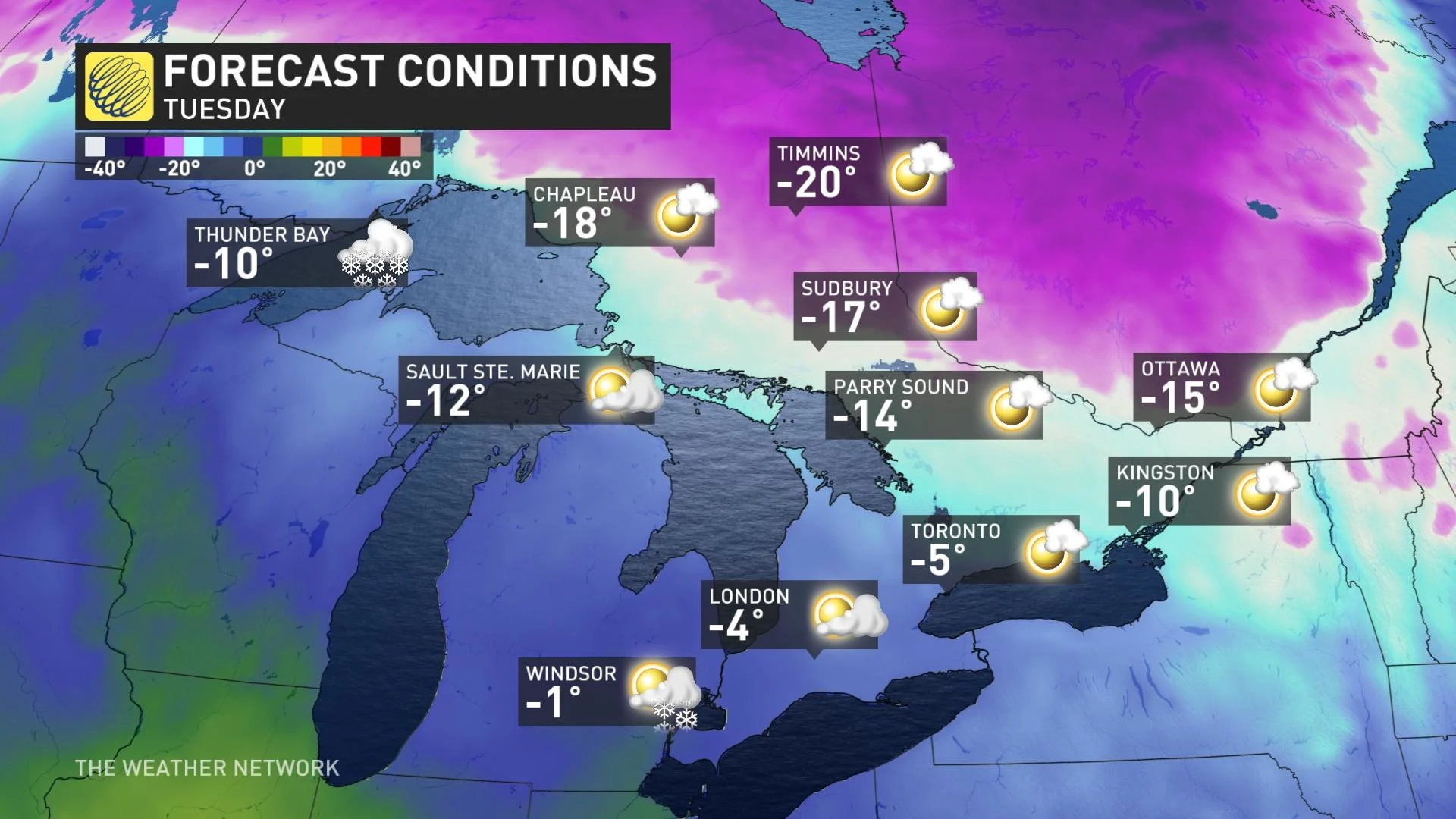
A clipper system with a few centimetres of snow is expected Tuesday night and into Wednesday, followed by another shot of Arctic air for Thursday and Friday. This wintry pattern is expected to continue through the final week of January with a couple more blasts of frigid weather to come.
Stay tuned to The Weather Network for the latest forecast for Ontario.