Powerful 'gigantic jet' seen over Oklahoma isn't what you think

One of the rarest forms of lightning, a gigantic jet was filmed over Oklahoma in May 2018, giving off a remarkable amount of charge between the troposphere and ionosphere
In May 2018, a gigantic jet was seen over Oklahoma.
That may seem like it was an ordinary observation referring to a large aircraft in the sky, but it wasn't. It is a rather dynamic and rare bolt of lightning, only occurring about 1,000 times a year, according to Tyler Hamilton, a meteorologist at The Weather Network.
"That might sound common, but get this: Earth sees approximately 1,000 lightning strikes every 10 seconds," said Hamilton.
SEE ALSO: ‘Heat lightning’ is summer’s peaceful and misunderstood secret
One lucky person managed to capture such an event. The citizen in Hawley, Texas, filmed the jet with a low-light camera on May 14, 2018, capturing the large discharge shooting out of a cloud top before it linked with charged particles in the ionosphere -- approximately 96 kilometres above the ground.
According to a recent study published in the Science Advances journal, this particular upper-atmospheric lightning bolt, a negative gigantic jet, transferred a remarkable amount of charge between the troposphere and ionosphere. It transmitted about 300 coulombs of energy, approximately 60 times the 5-coulomb output of an average lightning bolt, possibly the most forceful to date. It also discharged a significant area, about 60 kilometres-by-60 kilometres of the cloud.
By comparison, a typical gigantic jet emits more than 50 times the energy that a normal lightning bolt does.
"'Gigantic' lightning strikes are terrific conduits to transfer energy from the top of a cloud, shooting towards the lower portions of the ionosphere, nearly 100 kilometres above the surface of the Earth," said Hamilton. "This region of the atmosphere separates our thin atmosphere from space."
Event happened in odd circumstances
The study said the charge transfer is nearly double the previous largest amount by a gigantic jet and is comparable to the biggest ever recorded for cloud-to-ground strokes. The event was reported to have taken place in strange circumstances, with the parent storm cell marked by relatively warm cloud tops and a lack of turbulent mixing.

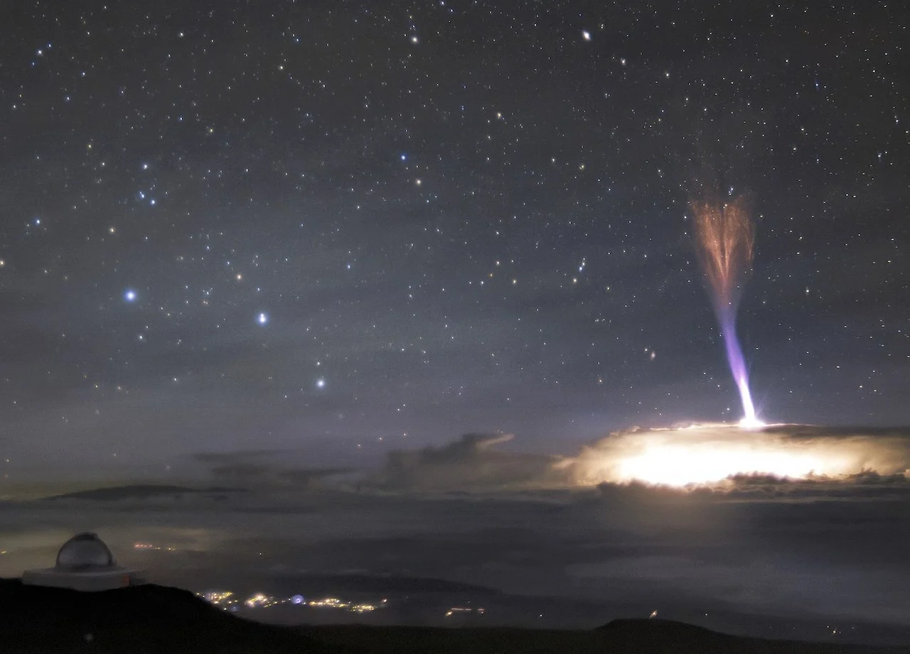
Gigantic jet taken on July 24, 2017 with an automatic camera from the International Gemini Observatory at 4,200 metres on Mauna Kea, Hawaii. (International Gemini Observatory/NOIRLab/NSF/AURA/A. Smith/Wikipeda. CC BY 4.0)
It also took place in very close proximity to the centre of a radio (very high frequency [VHF]) lightning mapping array, offering unmatched 3D VHF data that depicted the discharge inside and above the cloud, up to 45 kilometres altitude.
Researchers also noted other atypical characteristics of the May 2018 gigantic jet and its main storm. The jet happened in a Northern Hemisphere spring, was not associated with a tropical environment, and was located at relatively high latitudes.
Most gigantic jets have been documented to emerge from maritime tropical environments -- usually over the ocean and at low latitudes -- during hurricane season when ocean surface temperatures are warm (August to November in the Northern Hemisphere).
"There's more to learn about these rare backwards lightning strikes as they don't follow the typical, more common cloud-to-ground lightning activity so commonly seen," said Hamilton.
WATCH: When lightning strikes! Understanding the dangers of severe weather
Thumbnail courtesy of International Gemini Observatory/NOIRLab/NSF/AURA/A. Smith/Wikipeda. CC BY 4.0.
Editor's note: Thumbnail photo is not of the same gigantic jet as the one mentioned in the article. Thumbnail picture was taken on July 24, 2017.
Follow Nathan Howes on Twitter.


