Hurricane Ida, now weakened, leaves trail of destruction in southern U.S.

Ida weakened to a tropical depression on Monday, just one day after roaring ashore in southeastern Louisiana as a powerful, high-end Category 4 hurricane. The storm made landfall with maximum winds of 240 km/h, producing widespread wind damage and a life-threatening storm surge as it pushed inland. More on Ida’s aftermath and its impacts through the week, below.
TWO DEAD, ONE MILLION WITHOUT POWER AFTER INTENSE WINDS AND RAIN
Ida flooded a large portion of southeastern Louisiana with a destructive storm surge and torrential rains. The storm's extreme winds toppled trees and power lines.
The entire New Orleans metropolitan area lost power Sunday night after all eight transmission lines that deliver electricity to the city had failed, the utility company Entergy Louisiana reported.
According to PowerOutage.US, more than a million homes and businesses in Louisiana remained without electricity on Monday evening.
In Mississippi, the number of outages peaked at more than 100,000 customers before falling a bit through the day as crews restored service.
Entergy Louisiana sent out a tweet Monday saying it will likely "take days" to determine the extent of damage to its power grid and even longer to restore electrical transmission to the region.
Louisiana officials have reported at least two deaths as a result of the storm. Local news station KSLA-TV reported on Monday that a man drowned in New Orleans when he attempted to drive across a flooded roadway. Another man died Sunday night when a tree fell into his home in Ascension Parish.
MUST SEE: A hurricane in Louisiana is a threat that keeps meteorologists awake at night
New Orleans Public Schools announced Monday evening that all schools in the city would be closed “until further notice” as a result of the widespread power outages and ongoing damage assessments across the community.
The Thibodaux Regional Health System hospital in Lafourche Parish, southwest of New Orleans, lost generator power as a result of the storm, forcing medical workers to manually assist respirator patients while they were relocated to another floor, the state's health department told Reuters.
President Joe Biden declared a major disaster in the state, approving federal assistance to help boost recovery efforts in more than two dozen storm-stricken parishes.
Federal Emergency Management Agency (FEMA) administrator Deanne Criswell told CNN that the "full scale" of the storm would become more apparent later on Monday.
Preliminary reports have suggested that federal levees put in place to reduce the threat of flooding appeared to have maintained their ground.
"Daylight will bring horrific images as the damage is assessed. More than 20,000 linemen will work to restore the deeply damaged power lines," Shauna Sanford, communications director for Louisiana Governor John Bel Edwards, wrote in a tweet. "The good news: no federal levee failed or was overtopped."
Hurricane Ida hit the northern Gulf Coast at a sensitive time. Sunday was the 16-year anniversary of Hurricane Katrina’s landfall in Louisiana and Mississippi. The historic storm’s flooding and aftermath killed more than 1,800 people in the area, leaving an indelible mark on the region’s residents.
IDA SET TO PRODUCE FLASH FLOODING THROUGHOUT EASTERN U.S.
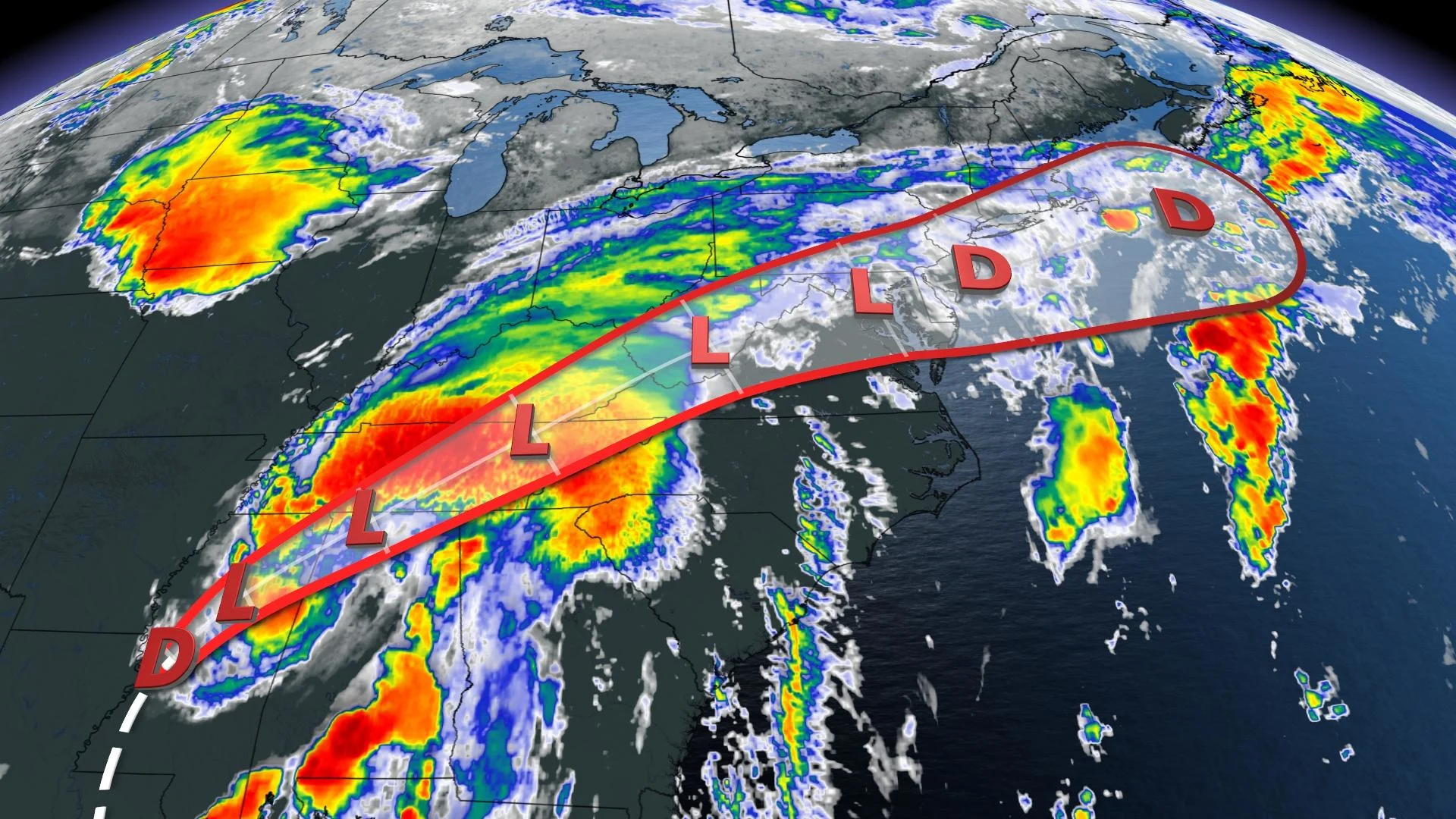
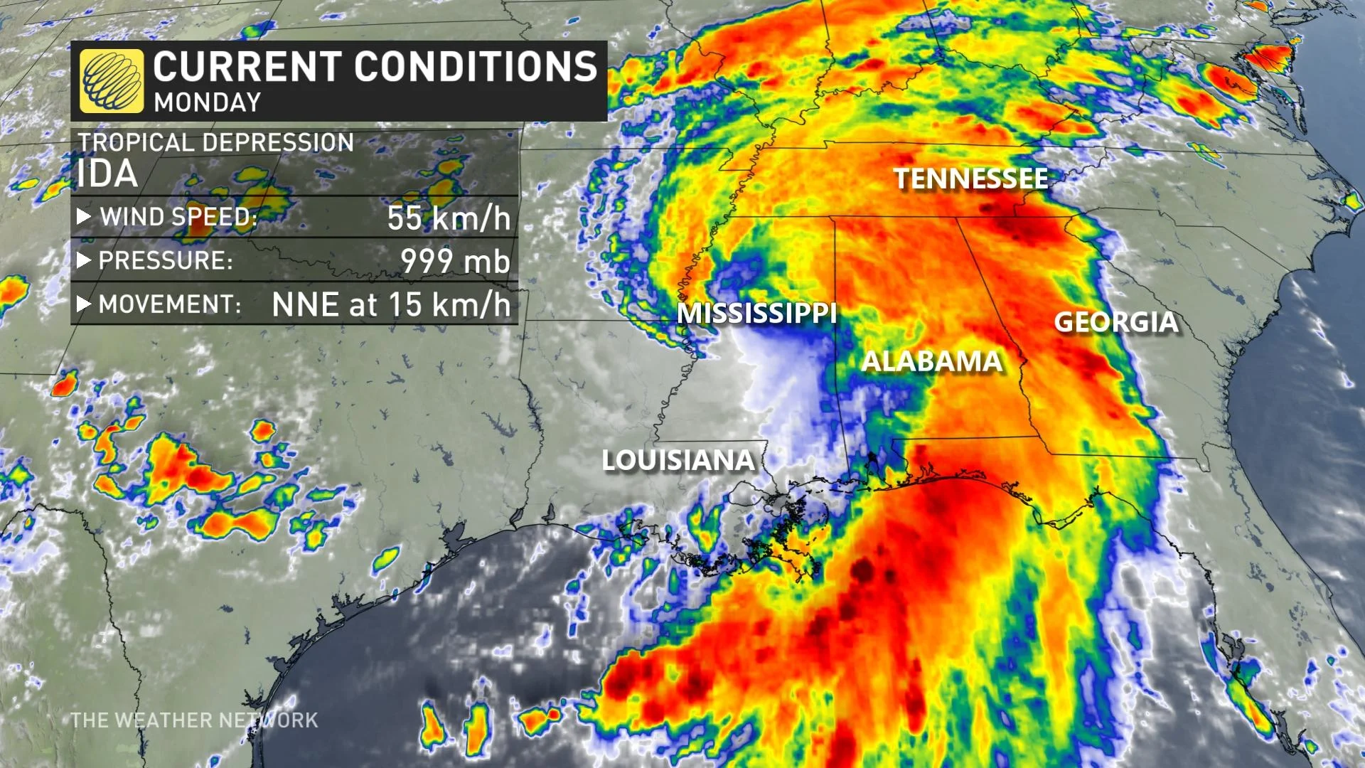
Ida continued to weaken on Monday as it moved over Mississippi, according to the U.S. National Hurricane Center (NHC). The system’s maximum sustained winds have decreased to 55 km/h with higher gusts.
Additional weakening is forecast during the next day or so, and Ida is expected to become a remnant low by Tuesday.
The storm will pick up a bit of speed as it passes over the Tennessee Valley on Tuesday, curving to the northeast as it gets swept up by the same cold front that will bring lower humidity to southern Ontario this week.
The latest forecast from the NHC shows the storm’s remnants moving over the Mid-Atlantic and Northeast through the end of the week.
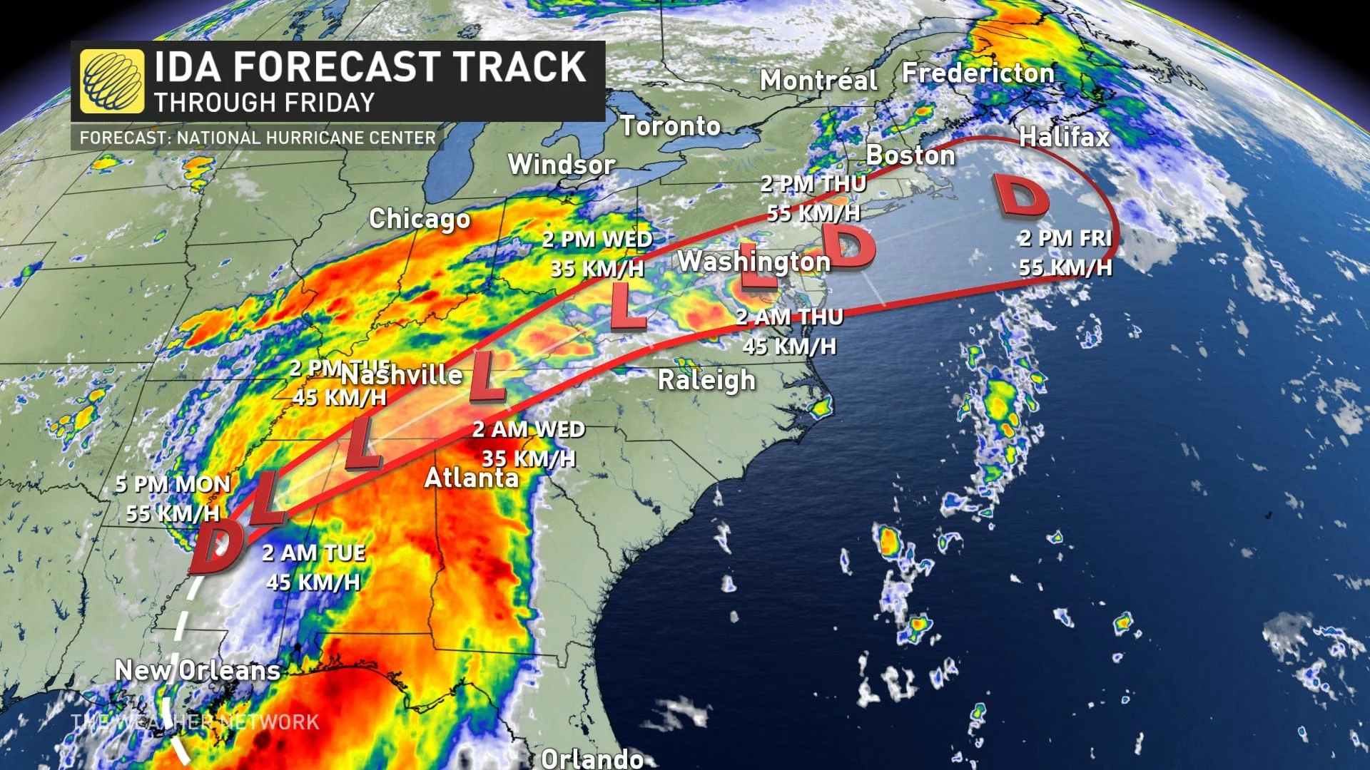
There is a chance Ida’s remnants could have some influence on the weather in the Maritimes by the end of the week or weekend, but because we're still days away, the forecast and track is subject to change. Check back throughout the week for the latest updates.
STAY PREPARED: Hurricane Preparedness: What you need in your kit
Meanwhile, Ida continues to produce flooding rains along its path.
Ida’s drenching downpours will continue as the storm heads into the Mid-South and Mid-Atlantic states over the next couple of days. Many communities will see 100-200 mm of rain over the course of the storm, with locally higher totals possible.
Enhanced wind shear on the eastern side of the system will bring a risk for tornadoes to parts of the southeast through the middle of the week.
Tuesday’s tornado risk will focus on Alabama, Georgia, and the Florida Panhandle, while Wednesday’s risk for tornadoes will move into parts of the Carolinas and the Mid-Atlantic.
IDA MADE LANDFALL AS A CATEGORY 4 HURRICANE
Ida grew into a high-end category 4 storm with maximum sustained winds of 240 km/h before landfall Sunday.
The storm made two landfalls in southeastern Louisiana on Sunday afternoon, bringing destructive winds, a life-threatening storm surge, flooding rains, and tornadoes to one of the most vulnerable stretches of coastline in the United States.
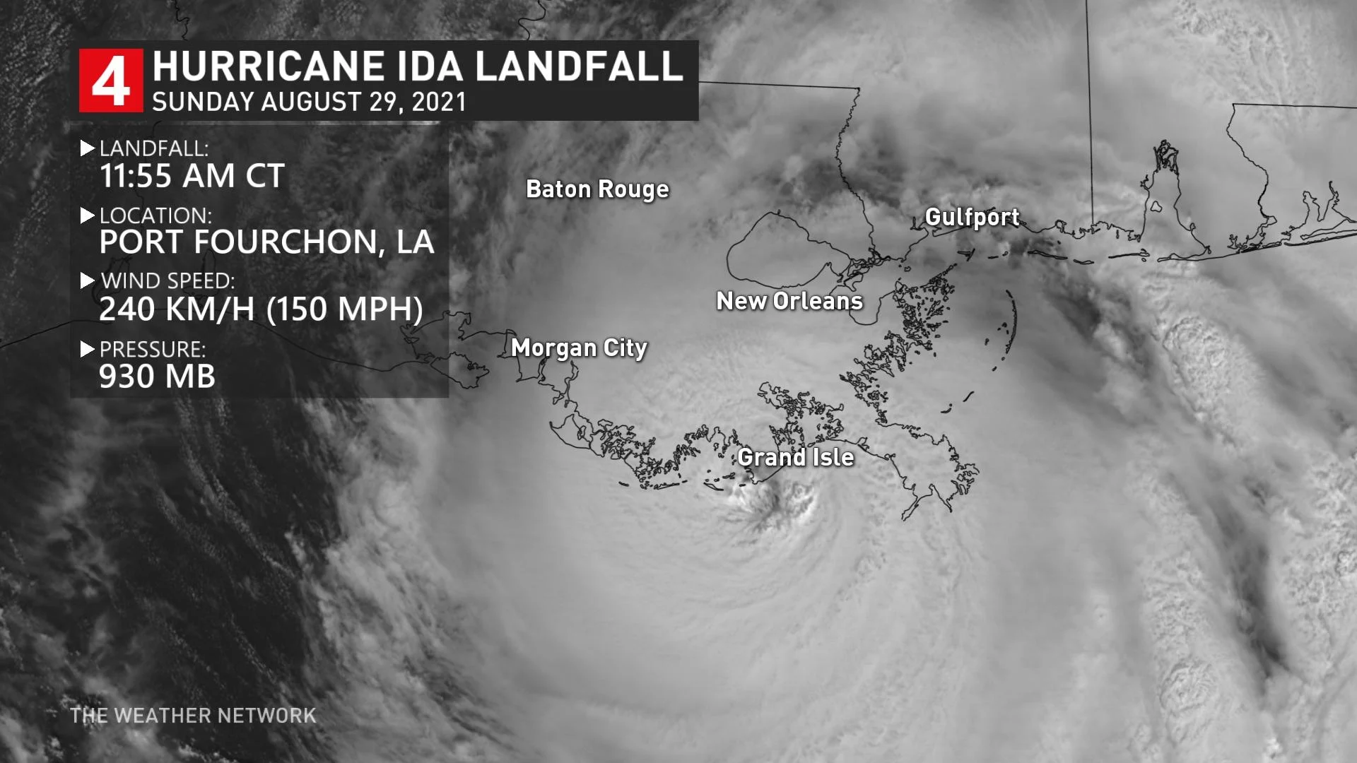
Ida first came ashore around 11:55 a.m. CDT near Port Fourchon, La., with maximum sustained winds of 240 km/h and a minimum central pressure of 930 mb, according to the U.S. National Hurricane Center (NHC).
Ida made a second landfall a few hours later in Galliano, La., with maximum sustained winds of 235 km/h and a minimum central pressure of 934 mb.
The hurricane didn’t immediately weaken after landfall. The warm water and low friction of Louisiana's swamps and marshes can help a hurricane maintain its composure. Hurricane Ida took advantage of this favourable environment to maintain major hurricane status for more than eight hours after landfall.
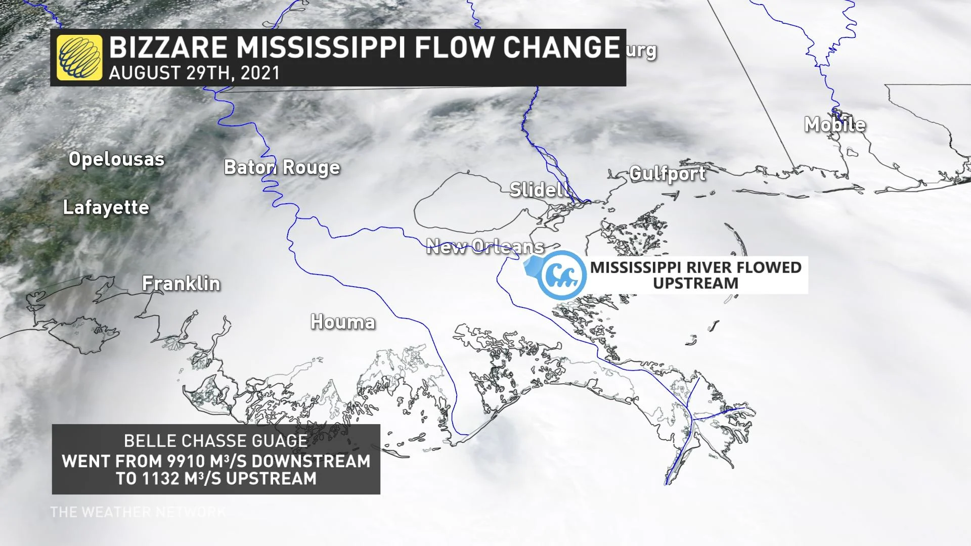
The hurricane's storm surge reversed the flow of the Mississippi River at one point on Sunday afternoon. A United States Geological Survey (USGS) sensor in Belle Chasse, La., recorded a negative river flow as the storm pushed ashore, indicating that the Mississippi River began flowing upstream.
A weather station in Lockport, La., reported a minimum pressure of 941.3 mb around 5:00 p.m. CDT as Hurricane Ida's eye moved overhead.
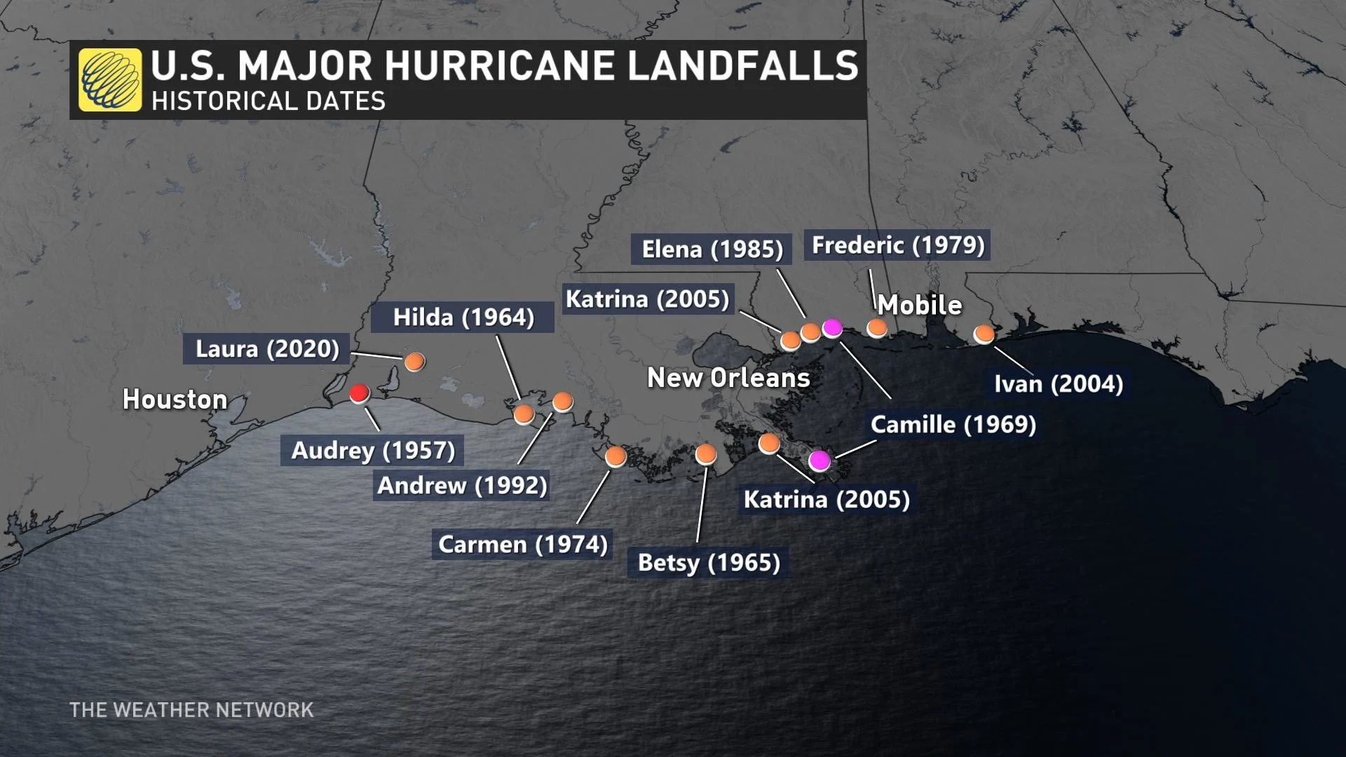
A LOOK AT THREE HISTORICAL, DEVASTATING U.S. GULF COAST LANDFALLING-HURRICANES
THE GULF COAST IS EXTREMELY VULNERABLE TO STORM SURGE
The northern Gulf Coast is a vulnerable spot for a strong hurricane to make landfall. The region has a long history of major hurricane landfalls, including Camille in 1969 and Katrina in 2005.
One of the greatest threats from any storm to hit this region is storm surge. The terrain of the Gulf Coast makes this region extremely susceptible to storm surge.
For example, much of Louisiana’s coastline consists of flat swamps, marshes, and beaches. This terrain offers little resistance to a storm surge, allowing seawater to push many kilometres inland from the coast.
The path of the storm left New Orleans, La., in a bad position on Sunday. The majority of neighbourhoods there reside at or below sea level, leaving the city prone to flooding from both storm surge and heavy rainfall.
With files from Reuters.
Stay tuned to The Weather Network as we continue to track Ida's progress.