Damaging wind risk spans southern Ontario as snow covers north

A strong low-pressure system brings in heavy snow for parts of northern Ontario, with widespread blustery winds impacting much of the province Wednesday.
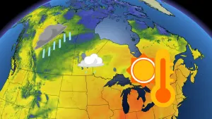
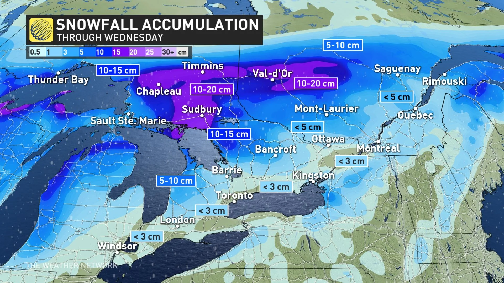
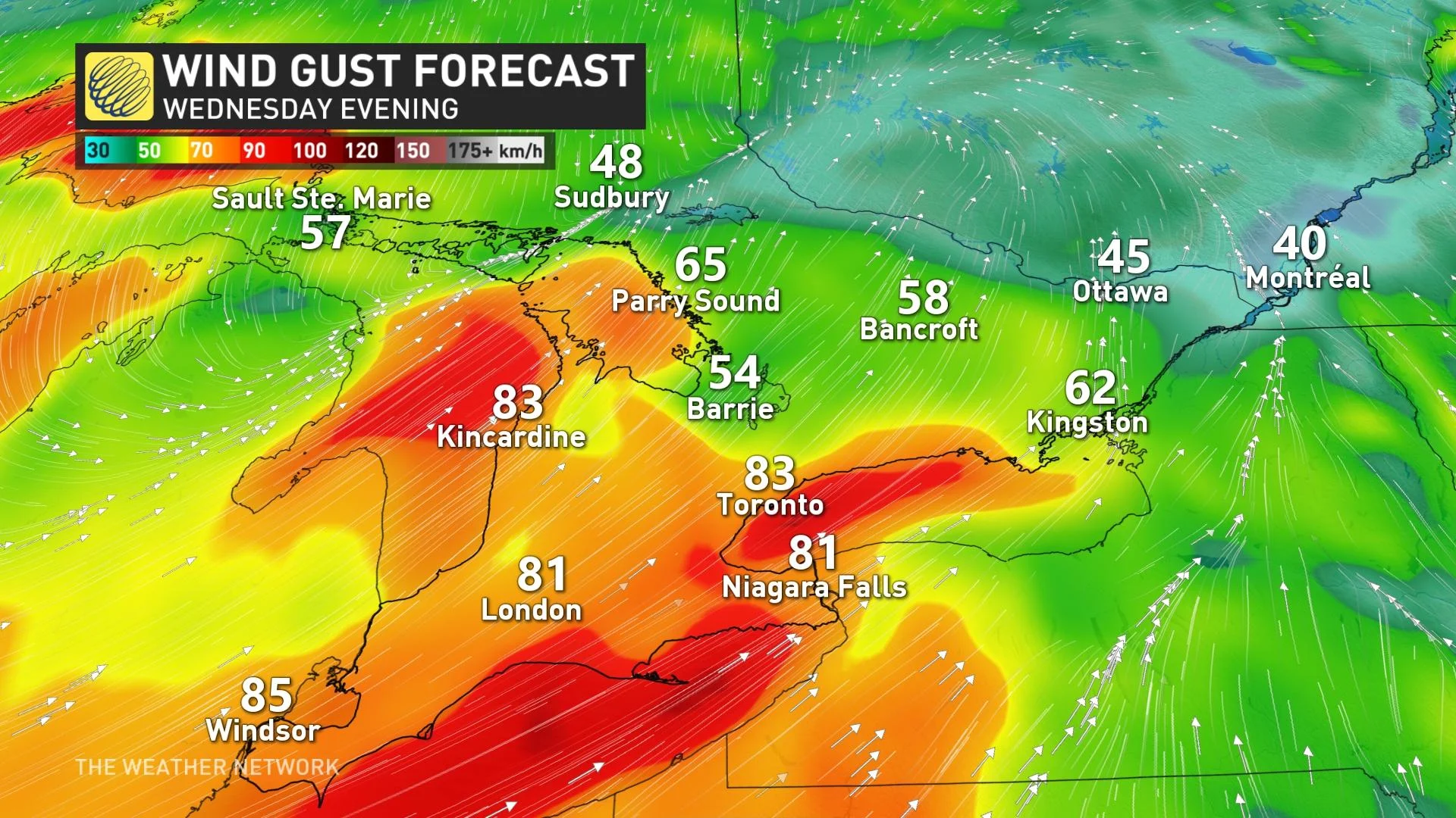
Well, it didn't take long for winter to welcome in the new year in Ontario. A potent low-pressure system is bringing a snowy blast in northern sections, while the south deals with milder temperatures and a threat for widespread damaging winds on Wednesday, along with some snow thrown in for good measure. A swath of 10-20 cm in northern Ontario threatens to impact travel, with the same effects in the south from potentially impactful 70-90 km/h winds. With snow added in, travel could be hindered in some spots, and there is also the risk of localized power outages from the wicked winds. More on the timing and details of the new year weather, below.
DON'T MISS: January promises nationwide 'pattern shakeup'
WEDNESDAY: HEAVY SNOW SPREADS ACROSS NORTHERN ONTARIO, POTENTIALLY DAMAGING WINDS WHIP THROUGH SOUTH
A system pushing across parts of northern Ontario prompted winter weather travel advisories. Light snow is expected to begin tonight before intensifying Wednesday morning. Snowfall rates of up to 3 cm an hour are possible at times.
A heavy swath of 10-20 cm is possible from just east of Lake Superior and northern Georgian Bay shores through Timmins and into central Quebec.
Northerly wind gusts will also pick up across northwestern Ontario, with gusts of 40-60 km/h expected to persist through the day on Wednesday.
"If visibility is reduced while driving, slow down, watch for tail lights ahead and be prepared to stop. Surfaces such as highways, roads, walkways and parking lots may become difficult to navigate due to accumulating snow. Visibility may be suddenly reduced at times in heavy snow. Road closures are possible," Environment and Climate Change Canada (ECCC) says in the winter weather travel advisory.
When you reach the south, the story switches up. A surge of milder air from a southerly flow will bump up temperatures Wednesday. However, bands of flurries will be possible at times as a cold front crosses the region on Wednesday afternoon, though any accumulations would be minimal if the snow does fly.
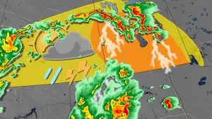
There will also be the threat of snow squalls to develop late Wednesday into Thursday in some areas that will be seeing the strongest winds. Places such as Fort Erie and Prince Edward County will be at risk.
Needless to say, the snow could reduce visibility through Wednesday afternoon and evening.
But the warmth comes with a price. Far-reaching powerful wind gusts of 70-90 km/h are expected on Wednesday, with the strongest occurring along the shores of Lake Erie and eastern Lake Ontario. There will be the risk of isolated power outages, and if you have any loose outdoor furniture, place them inside or ensure they're tied down.
LOOK AHEAD: TEMPERATURE ROLLER-COASTER CONTINUES THROUGH MID-JANUARY
Forecasters were closely watching a developing winter storm tracking south of the U.S. border for the end of the week, though at this point, it looks like most of the heavy snow will stay south of the border.
Temperatures will remain cold through the first half of the weekend, briefly warming up on Sunday with rain showers expected.
By early next week, a strong cold front crossing the region threatens some of the coldest weather of the season so far, with overnight temperatures set to dip into the -20s, feeling even colder with the wind chill.
After this quick shot of arctic air however, milder temperatures are expected to return during the second half of next week, with a changeable temperature pattern set to persist through mid January.
Thumbnail courtesy of Adrianna Medyk, taken in Mississauga, Ont.
Be sure to check back for the latest weather conditions as we kick off this new year in Ontario.