How Saharan dust is putting a lid on hurricane season
Atlantic Hurricane Season got off to an early start this year, but it's been pretty quiet since Subtropical Storm Andrea churned up the waters near Bermuda in May.
Now we're almost to the end of June, and there's no sign of Barry -- the next storm name on this year's list. In fact, a massive plume of Saharan Desert dust means that Barry may be buried for at least the near future.
Summer revealed! Visit our Complete Guide to Summer 2019 for an in-depth look at the Summer Forecast, tips to plan for it and much more
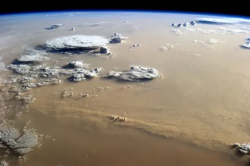
Dust makes the 8,000-kilometre journey from northern Africa across the Atlantic every year and can have a significant impact on everything from hurricane activity to the colour of the sunset in eastern North America. A new shot of this so-called Saharan Air Layer emerges over the North Atlantic Ocean every three to five days, on average, from late spring to early fall.

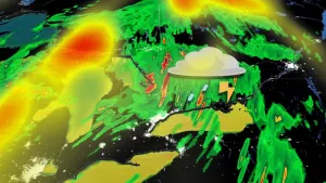
Satellite loop from June 18 shows a haze of dust stretching across the Atlantic from Africa to the Caribbean. Image courtesy NOAA.
The dust doesn't always make it all the way across the ocean, but the current plume -- seen in the image above -- was a large one. It departed Africa in mid-June and has been making its way into the U.S. eastern and Gulf coasts this week, to the delight of sunset-watchers.
This dust layer also gives us a clue as to why the tropics are quiet when it comes to hurricane activity. It's only the dust, but the dry air and wind that go with it, that makes it hard for tropical cyclones to get going in the Atlantic.
The extremely dry desert air in the middle layers of the atmosphere makes it hard for convection (thunderstorms) to get started in the early stages of a tropical disturbance. The strong winds that surge out over the ocean with the dust storm also increase wind shear (winds changing direction and/or speed with height), something severe thunderstorms like but hurricanes definitely don't. And the dust itself can eat away at what moisture is available, by serving as condensation and causing it to fall before it can fuel a bigger storm.
While the U.S. National Hurricane Center is watching a few tropical waves -- the typical precursors to hurricanes -- no development is expected for at least the next five days.
Sources: NASA | The Washington Post |