Southern Prairies on alert for strong squall line risk Saturday evening
Stay alert for watches and warnings on the southern Prairies as the potential grows for a strong squall line on Saturday evening
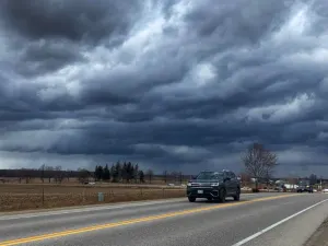
The potential is growing for a strong squall line known as a mesoscale convective system (MCS) rolling across portions of the southern Prairies late Saturday and into the overnight hours.
This organized line of storms could pack damaging wind gusts and possibly one or two embedded tornadoes as it sweeps through the region.
Pay close attention to watches and warnings in your area, proactively keep an eye on the radar for approaching storms, and prepare to seek sturdy shelter if dangerous conditions threaten your community.

DON’T MISS: How severe weather alerts are issued, and potentially save lives
Storms build Saturday afternoon
A low-pressure system pushing into Saskatchewan will serve as the spark for thunderstorms to develop through Saturday night.
Scattered storms developed across southern portions of Saskatchewan and Manitoba on Saturday evening.

RELATED: Why nocturnal thunderstorms can be particularly dangerous
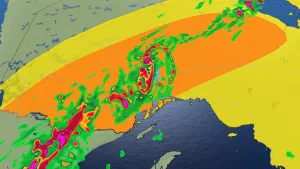
Forecasters are increasingly concerned about the potential for a MCS, a strong and organized squall line, pushing across southern portions of Saskatchewan and Manitoba through Saturday evening and into the overnight hours.

The main threats with this line of storms would be damaging wind gusts, large hail, and heavy rainfall. One or two tornadoes can’t be ruled out.
The greatest severe risk focuses on southeastern Saskatchewan and southwestern Manitoba, covering communities like Estevan, Moosomin, and Brandon. The risk for severe storms extends outward to include Winnipeg, Regina, Dauphin, and all the way north toward The Pas.

Remain alert for watches and warnings through the night, and stay close to safe shelter in case thunderstorms loom on the horizon.
Looking ahead, much of the Prairies can expect a chilly start to the week behind a cold front, with temperatures returning to near seasonal by the summer solstice on Thursday.
Check back for all the latest on your forecast across the Prairies.