Fall chill sends temperatures diving in Ontario with snow for some

Ontario residents will need to keep the jackets, sweaters, and maybe even toques handy this week as an unseasonable chill descends into the province, bringing with it a threat for frost and snow.
Fall is in full force in Ontario this week, thanks to a persistent trough over the Great Lakes. As a result, this will lead to multiple low-pressure systems moving in with ample amounts of precipitation for parts of the province, and a noticeable plummet in temperatures that will feel more reflective of November. Lake-enhanced moisture will lead to 30-60 mm of rain for parts of Ontario through Thursday, along with the chance of lake-effect snow in different regions. For timing and impacts, read below.
This week: Windy, wet and chilly
Temperatures will plunge across northern sections of the province Tuesday, with some communities struggling to push their daytime high temperatures above the freezing mark.

Southern Ontario is beginning to see the start of the cooldown, with conditions favourable for graupel, reported in many locales on Monday. This could occur again this week.
By mid-week, daytime highs in Toronto will only reach the upper single digits, with even chillier conditions expected for folks up towards cottage country.
Wind speeds will strengthen early to mid-week, allowing for a wind chill to kick in and make conditions feel much cooler.
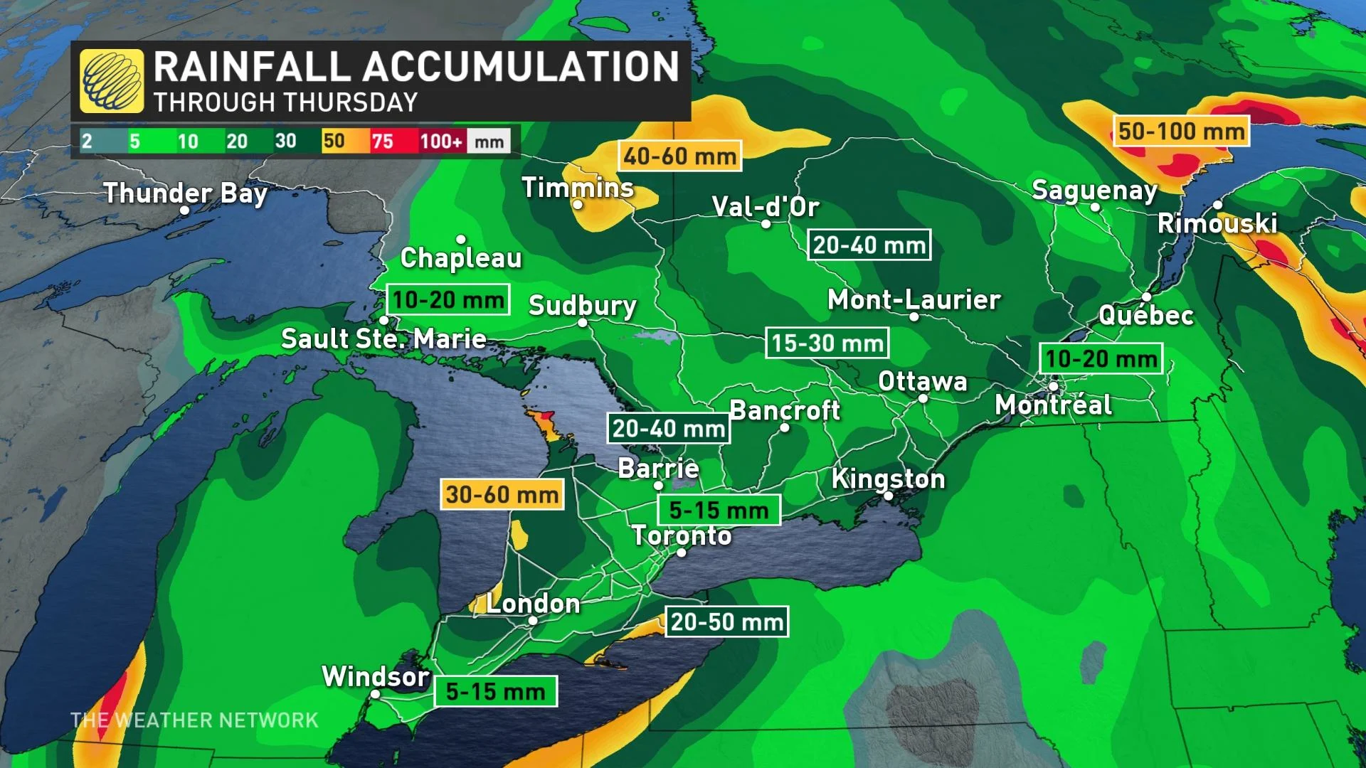
With the trough in place, some areas are looking at considerable amounts of rain this week. The Lake Huron shorelines could see anywhere from 30-60 mm, 40-60 mm for parts of northeastern Ontario and 20-40 mm on tap for parts of cottage country.
Fall Forecast revisited: The good, the bad and the ugly
The upcoming bout of cold air is more like what you’d expect to see in November than the middle of October. Daytime highs will be five to eight degrees below seasonal with overnight lows will hovering near 0°C.
We're also on the lookout for the chance for snow across the province.
The low-pressure system will continue to swirl over the Great Lakes, wrapping in cold air with it. Temperatures will be cold enough, and the atmospheric pattern will be favourable enough, so that any precipitation moving through the region could fall as wet snow.
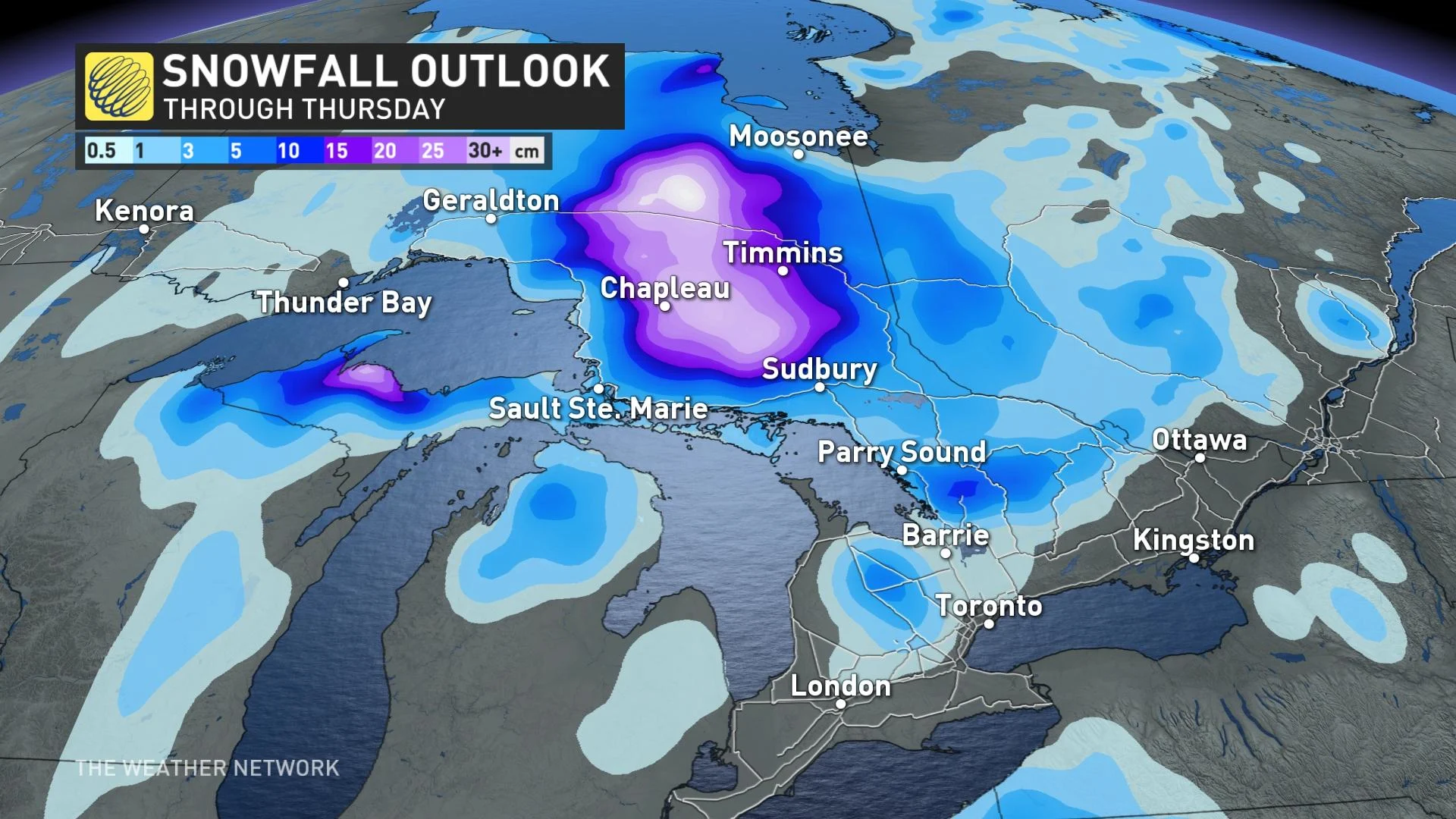
In northern Ontario, snowflakes will fall north of Lake Superior and spread eastwards into Wednesday with wet snow or mixing expected at times. For areas in northeastern Ontario, east of Highway 144, it will be mainly rain that will fall, until Wednesday when cooler temperatures dominate and the precipitation changes over to snow.
"As much as 10-20 cm of snow is possible to accumulate in areas northeast and east of Lake Superior," says Matt Grinter, a meteorologist at The Weather Network.
The low will also prompt rounds of lake-effect showers through mid-week and help push wet snow into some of the higher elevations of southern Ontario, potentially above the escarpment and over the Dundalk Highlands.
MUST SEE: Extreme temperature anomaly scrambles North America's weather pattern
"As we head into Wednesday overnight and Thursday morning, it is possible that with colder temperatures at the surface and aloft, lake enhancement flurries are possible for areas east of Lake Huron and Georgian Bay," Grinter adds. "This will be the best chance for accumulating snow in southern Ontario."

While the November-like weather will dominate much of this week, forecasters are watching the potential for a few days of milder weather during the final week of October.
WATCH: Take in the spectacular fall colours at these popular GTA pumpkin patches
Stay tuned to The Weather Network for the latest forecast across Ontario.