Snowy winter provides blast of hope in some parts of drought-stricken Prairies
It just keeps coming. More snow.
For many parts of the Canadian Prairies, it's more of the white stuff than they've seen in years.
At Stan Jeeves's cattle and grain farm near Wolseley, Sask., 100 kilometres east of Regina, strong winds have blown the snow into huge piles that engulf his hay bales. He's already had more than 60 centimetres of snow this winter, compared with just three centimetres at this point last winter, according to Environment Canada data.
"I think it's given me some optimism, for sure," Jeeves said. "We're receiving fairly regular snows, and so if that continues through the growing season into timely rains, we should be much better off than we have been in the past two or three years."
And while the snowfall he's seen this year is close to the historical average, the 70-year-old farmer has almost forgotten what normal looks like.
Prairie farmers have faced dry conditions for years, with last year breaking records for lack of rain and unrelenting heat.
DROUGHT OUTLOOK IMPROVES
The latest drought monitor report from Agriculture and Agri-Food Canada projects that a large area of the Prairies could be delisted as a drought zone by the end of February.
All parts of the Prairies, except southern Alberta and southwestern Saskatchewan, have received near-normal to above-normal precipitation this winter season, according to the report. In particular, a wide swath that stretches from north of Edmonton to Winnipeg has received high precipitation, slightly easing drought conditions.
The following two maps illustrate the current drought conditions in Canada and what's forecast to change.
The first map, with drought conditions as of Jan. 31, shows 61 per cent of the Prairie region still ranges from abnormally dry to exceptional drought. However, it also reveals some improvements. In Manitoba, for example, the areas once considered to be in an extreme or exceptional drought have "significantly reduced due to very high precipitation in the last six months as well as improved long-term conditions."
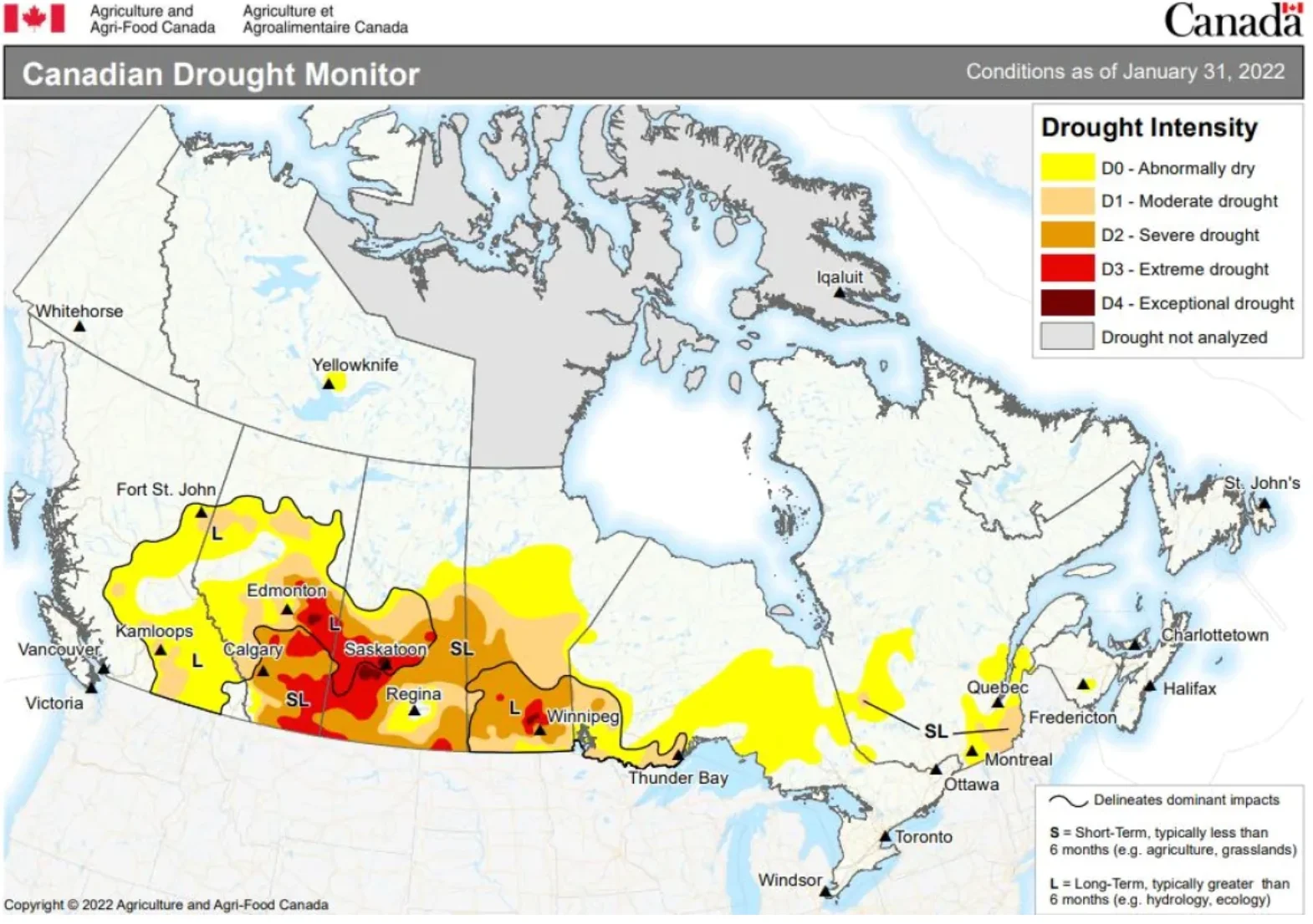
The latest drought monitor report from Agriculture and Agri-Food Canada shows the extent and severity of drought conditions across the country as of Jan. 31. Extreme drought regions still exist in central Saskatchewan and parts of Manitoba, but the coverage area has significantly reduced. (Agriculture and Agri-Food Canada)
SEE ALSO: Regina working to shave down road ruts on residential roads
The second map, illustrating the drought outlook for the end of February, shows several areas marked in green for "drought removal" and yellow for "drought improves." The report suggests that most of Manitoba, eastern Saskatchewan and a northern strip of Saskatchewan and Alberta could be removed from the drought zone.
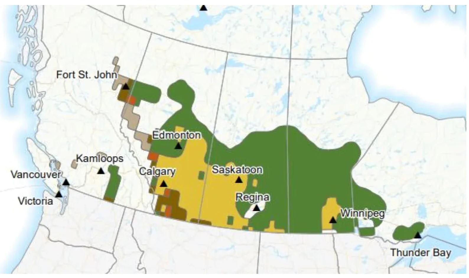
Agriculture and Agri-Food Canada's latest drought outlook predicts conditions will improve in several parts of the Prairies by the end of February. The area in dark green indicates 'drought removal' and yellow indicates 'drought improves.' (Agriculture and Agri-Food Canada)
"It's not as if this is money in the bank, but this is a sign that it's not going to be another bad year," Environment Canada senior climatologist David Phillips said. "The feeling is that maybe Mother Nature has not forgotten how to rain or snow on the Prairies."
Unfortunately, much of southern Alberta and southwestern Saskatchewan have been short-changed so far.
But Phillips said there's still hope.
"In areas that haven't had as much [snow], say, in southern Alberta, if they get snows now that are much more moist, more water associated with it, that would be more valuable for agriculture and ranching than snow that flies in December and January, which is drier," he said.
WATCH | HOCKEY AND BLIZZARDS: HAYLEY WICKENHEISER TALKS ABOUT WINTER IN SASKATCHEWAN
QUALITY OF SNOW, NOT JUST QUANTITY
Retired meteorologist Rob Paola is a volunteer weather observer who uses a ruler to measure the new snowfall and total snowpack every morning from his official Environment Canada weather station in his backyard in southwest Winnipeg.
So far this winter, the city has received more than 156 centimetres of snow, with two more months to go. The average snowfall for an entire winter is about 127 cm, he said.
But Paola also melts the snow to calculate how wet — or dry — it is.
"Wet snow holds more water, while fluffier snow holds less water," he said. "Over the course of a winter, that can determine how much potential moisture is locked in the snowpack for the spring melt."
Dry, powdery snow that builds up on the frozen ground in the coldest months of winter won't necessarily turn into valuable moisture when the ground thaws in the spring. In comparison, those big, wet snowflakes that fall in April are more likely to provide dry soil with a decent drink of water.
"Once the snow melts into the ground, that should improve soil moisture conditions," Paola said.
WATCH | MOST ACCURATE WAYS TO MEASURE SNOW
MELT RATE, SPRING SNOW AND RAINS ARE CRITICAL
Both Paola and Phillips say there are plenty of unknowns in the next eight to 10 weeks that will determine how much moisture soaks into the soil, fills dugouts or causes flooding. That includes how quickly the ground thaws and snow melts, how much more snow falls and the amount of rain that follows.
"As we get into March and April, we can get some significant late-season storms. Some of our biggest snowstorms in Winnipeg have happened in March and April," Paola said.
Provincial agencies in Manitoba and Saskatchewan that released preliminary runoff outlooks last week also cautioned that the spring melt rate will determine how much moisture is absorbed by the soil. In favourable weather conditions, the risk of flooding in Manitoba is low to moderate, but it jumps to high in unfavourable weather conditions, according to the province's Hydrologic Forecast Centre.

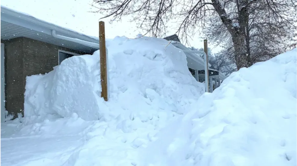
Snow piles up against a seniors' complex in Meadow Lake, Sask., in early February. The small city in northwestern Saskatchewan has received above-normal precipitation since the start of winter. (Bonnie Allen/CBC)
In Saskatchewan, the Water Security Agency predicts that the spring runoff potential for the southern third of the province is still "below normal" or "well below normal."
At his farm east of Regina, Stan Jeeves says he isn't counting on the current snow supply alone to reverse years of abnormally dry conditions.
"I don't think it will do all that much for the sub-soil moisture. We're going to need some timely rains, for sure, to make a good crop," he said. "We should have enough moisture for germination. We'd like some good rains in June, and then through July and early August to finish the crop off."
This article, written by Bonnie Allen, was originally published to CBC News.