UPDATED: What we expect for the heart of Canada's summer season

An update on conditions for the heart of summer
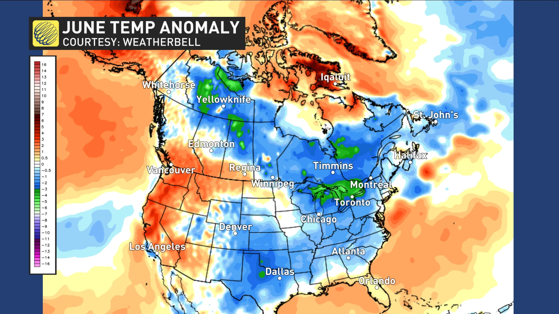
Summer weather has been unusually slow to arrive across most of the country this year. While western Canada has seen periods of hot weather (even record heat), most of Canada has continued to be colder than normal during June. The map below shows the temperature anomalies for June 1 to 19, with blue and green highlighting the widespread colder than normal temperatures.
Visit our Complete Guide to Summer 2019 for tips to plan for it and much more
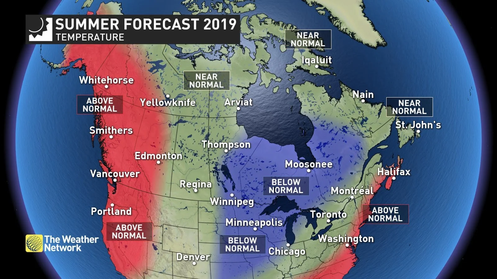
This pattern will continue for a few days beyond the official start of summer on June 21, but it is much too early to write off the entire summer season. We still expect that summer will show-up. The maps below show our updated forecast for end of June, July and August.
EXPERT: How much SPF do you REALLY need? Answer may surprise you

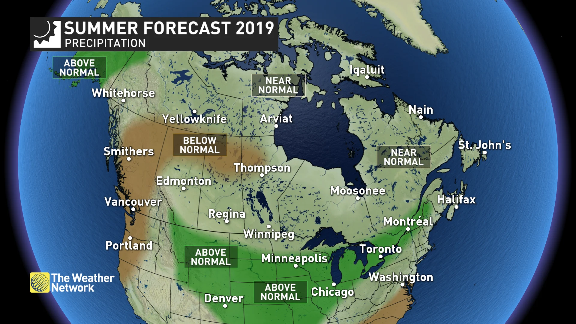
Our forecast continues to highlight another hot and dry summer across B.C. with a heightened threat for wildfires. A changeable summer is likely from the Prairies, through Ontario, Quebec and Atlantic Canada, with less extreme heat compared to last summer. This changeable pattern contributes to the potential for periods of stormy weather with near normal or above normal rainfall expected much of Canada east of the Rockies. However, northern parts of the Prairies are expected to be drier than normal, and that dry pattern could end up extending further east into northern Ontario.
Below is a more detailed look at the conditions that we expect across Canada this summer.
SEVERE WEATHER: Why do people ignore severe weather warnings?
BRITISH COLUMBIA
A very warm summer is expected with a heightened risk for extended periods of hot and dry weather, especially across the Interior. An extended period of cooler and unsettled weather during late June will help to temporarily ease wildfire concerns, but we expect that a very warm and dry pattern will resume for the majority of July and August with a higher than typical threat for wildfires and smoky conditions during the second half of the season.
MUST READ: Four ways extreme heat plays havoc with society
WATCH BELOW: SEVERE DROUGHT CONDITIONS ON THE RISE FOR B.C.
ALBERTA
A warm summer is expected across most of Alberta, though there will still be periods of cooler weather at times. Near normal temperatures are expected across eastern Alberta. Smoke from wildfires will continue to be an issue, but a period of wet weather through the end of June will temporarily ease those concerns. Rainfall totals are expected to be near normal across much of the province, but drought and wildfire concerns will continue across northern areas. Meanwhile, above normal rainfall is expected for southwestern Alberta.
WATCH BELOW: 'TALE OF TWO TEMPERATURE PATTERNS' FOR SUMMER ON THE PRAIRIES
SASKATCHEWAN AND MANITOBA
A changeable summer is expected across the region with back and forth swings in temperature that will likely tip to the cool side of normal across most of Manitoba. After a very dry start to the growing season, late June is bringing widespread beneficial and even excessive rainfall. For the remainder of the summer we expect near normal rainfall, but northern areas are at risk for drier than normal conditions. Smoke from wildfires to the west and northwest will likely be an issue during the summer.
ONTARIO AND QUEBEC
A changeable summer is expected across the region. Across southern areas we expect that the back and forth swings in temperature will come close to offsetting each other, while northern areas are expected to tip to the cool side of seasonal. However, it looks like we will continue with our recent trend of warm Septembers with above normal temperatures expected throughout the region.
SEE ALSO: This summer is shaping up to be the best beach year yet
An active and stormy pattern is expected to continue well into the summer, especially across southern areas with a heightened risk for thunderstorms and severe weather, especially flash flooding. However, northern areas are at risk to trend drier and we will be closely monitoring that threat as the season progresses.
WATCH BELOW: ONTARIO REMAINS 'BATTLEGROUND' BETWEEN SUMMER WARMTH AND NORTHERN CHILL
WATCH BELOW: ACTIVE STORM TRACK TARGETS QUEBEC'S SUMMER
ATLANTIC CANADA
A humid summer is expected across most of Atlantic Canada. After a slow start to the summer season, we expect that warmer than normal temperatures will become more dominant during July and August across the southern Maritimes with near normal temperatures expected elsewhere. However, coastline areas will often be cooler with a higher than normal potential for fog. Near normal rainfall is expected across the region.
SEASONAL: Five plants that are nearly impossible to kill
WATCH BELOW: HOT AND STICKY SETUP FOR ATLANTIC CANADA
NORTHERN CANADA
A warmer than normal summer is expected for Yukon and western Northwest Territories, and near normal temperatures are expected for eastern Northwest Territories and Nunavut. Near normal precipitation is expected across most of the region, but southern parts of the region are at risk to be drier than normal. Wetter than normal conditions are expected for far western parts of Yukon. This summer does have a heightened risk for wildfires and smoky conditions.


