Quebec begins to dig out after powerful winter storm drops heavy snow

A major snowstorm that closed roads and caused collisions in parts of Quebec Monday, also bringing hefty accumulations for some, will be winding down through the overnight period, allowing for a break from the stormy weather Tuesday.
Similar to Ontario, Quebec was on the receiving end of a major snowstorm Monday, prompting road closures on highways 20 and 30 for several hours on Montreal's South Shore due to pileups. Conditions were quite poor as heavy snow and blustery winds made for poor visibility. Some areas picked up more than 30 cm of snowfall. The good news is the snow will begin to diminish for most regions by the overnight hours, allowing for a break from the winter weather on Tuesday, though the morning commute is still likely to be impacted by slippery roads. More on when to expect the snow to end and what lies ahead for the rest of the week, below.
PHOTOS: WINTER STORM WALLOPS ONTARIO, QUEBEC, DRIVERS SHOVEL ON THE SIDE OF THE HIGHWAY
A powerful low-pressure system blasted southern Quebec with a winter wallop on Monday, resulting in significant interruptions to traffic including road closures and collisions.
Here are some current snowfall totals (Sunday night to Monday) as of Monday evening.
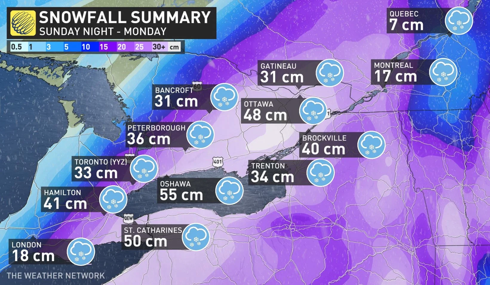
Gatineau has picked up 31 cm so far, with 17 cm in Montreal and 7 cm in Quebec City.
The snowstorm prompted some school closures across the province. Montreal’s English Montreal School Board and Lester B. Pearson School Board both called snow days on Monday due to the storm.
As well, provincial police said there have been many accidents, including pileups involving dozens of vehicles that forced Transports Québec to close some highways on Montreal's South Shore, reported by CBC News.
The intense snowfall rates left road crews scrambling to keep up, making travel nearly impossible at times. Blustery winds combined with heavy snowfall significantly reduced visibility at times.
Snow should begin to subside for most communities by Monday overnight, but winds will remain gusty during this time, making for tricky travel due to blowing snow.
WATCH BELOW: WINDS TO CONTINUE OVERNIGHT ACROSS QUEBEC, WHITEOUTS A THREAT
TUESDAY AND BEYOND: MORE CHANCES FOR SNOW AND MUCH COLDER THAN SEASONAL
We’ll catch a bit of a break across southern Quebec on Tuesday as skies clear out behind the storm and winds calm down. However, snow-covered roadways will likely hinder travel for the Tuesday morning commute.
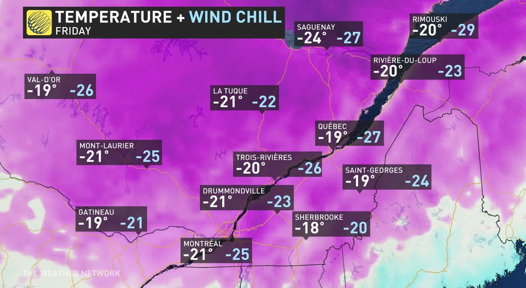
Temperatures will remain colder-than-seasonal for all of southern Quebec through this weekend—and likely beyond. High temperatures will struggle to climb out of the double-digits below zero for most areas.
A shot of Arctic air arriving by the end of the week will make conditions particularly frigid. Montreal’s predicted high of -21°C on Friday would come in three times colder than normal for the date.
A clipper system trekking into Central Canada looks to bring more snow to southern Quebec on Wednesday, with another 5-10 cm of accumulations. The pattern appears favourable for a system to move in sometime between the weekend and early next week, but much too early for specifics.
With files from CBC News.
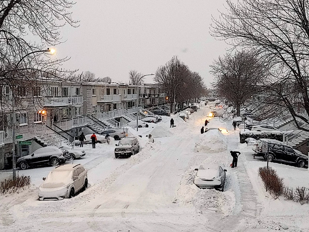
Thumbnail courtesy of @ThatMTLGirl/Twitter, taken in Montreal, Que.
Stay tuned to The Weather Network for all the latest updates on weather across Quebec.