Busted! A look back at what happened to winter, looking ahead to February

There is no point trying to sugar coat it, our temperature forecast for the winter has busted.
There is something that I find very peculiar about Groundhog Day, and I am not referring to the notion that seeing a shadow can tell us anything about when spring will arrive. What surprises me is the level of interest in whether we will have an early spring or six more weeks of winter. Are those two options not saying the same thing?
GROUNDHOG DAY 2020: The results are in, but the vote isn't unanimous
Six more weeks takes us to March 15. If consistent spring weather were to arrive during the middle of March, would we not consider that to be an early spring across most of Canada? My experience has been that it’s the years when we get 8, 10 or even 12 more weeks of winter (like last year) that most people start to get upset. Unfortunately, Groundhog Day isn’t able to tell us about those years with such extended winters.
On February 25 we will issue our official Spring Forecast with a more detailed look at what we can expect during March, April, and May. But, for now, we will take a look at what we expect for the month of February and explain why our temperature forecast for the winter has been a bust so far.
SEE ALSO: January ranks as one of the gloomiest in 7 years
WHERE IS THE CONSISTENT COLD WEATHER?
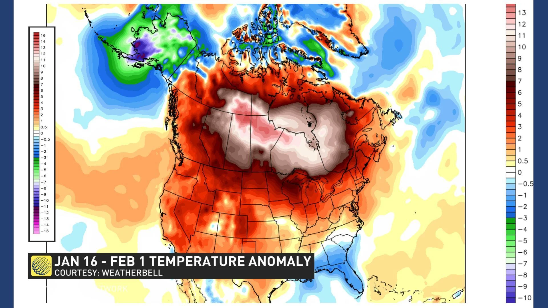
Mild Pacific air has dominated across most of Canada during the past two weeks. The Prairies have seen temperatures 10 to 15 degrees above seasonal as highlighted on the temperature anomaly map shown below, valid for the past two weeks.
However, a pattern change is already underway. More typical winter weather is in the process of returning to central Canada, though temperatures are still very mild compared to what the Prairies saw during the first half of January.
This colder (near seasonal) weather will continue to spread east into Ontario and Quebec this week, but it will run into resistance from mild air that will continue to stream north from the Gulf of Mexico. This will lead to an active pattern from southern Ontario to Atlantic Canada and that pattern is expected to continue through the middle of February.
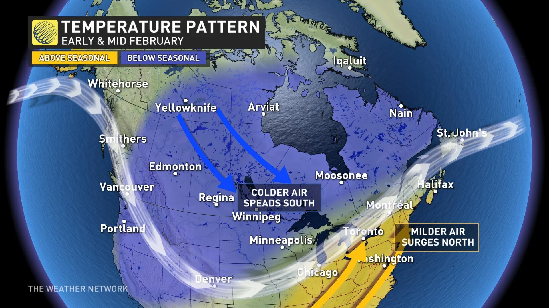
While we will not see consistent severe cold weather from Ontario to Atlantic Canada during February, seasonal temperatures are still low enough that significant snow and ice can readily occur within an overall mild pattern. Parts of this region will likely see well above normal snow and ice through the middle of February, and possibly into late February as well.
During the second half of February, the focus of the coldest weather will continue to be across western half of Canada, but it will spread east at times. Meanwhile mild air will continue to attempt to take over the pattern from Great Lakes to the Maritimes. Both the cold air and the mild air have the potential to dominate for several days during the second half of February, but most likely the Great Lakes to the Maritimes will continue to be the battleground, resulting in a continuation of the active storm track with messy systems.
WINTER FORECAST RECAP: OUR TEMPERATURE FORECAST A BUST!
There is no point trying to sugar coat it, our temperature forecast for the winter has busted. We still expect a strong finish to winter during February and into March, but it is too late to salvage the temperature forecast.
However, our snowfall and precipitation forecasts are still on track (except for B.C.) as we have seen an active pattern with near normal or above normal precipitation and snowfall across most of Canada.
MUST SEE: Rain from single storm in B.C. exceeds what most Canadians see in a year
The season started off as expected with a fast start to winter weather during November and then we transitioned into the changeable pattern that we expected for December. However, after that, we failed to lock into the pattern that we expected for mid and late winter.
SEASONAL FORECASTS LIKE PRE-SEASON PREDICTIONS IN SPORTS
I like to compare seasonal forecasts to preseason predictions in sports. These predictions are made based on the past performance of the players on the team. While it is not possible to predict every winning and losing streak of the season, one can have some skill in identifying teams that will contend for the playoffs or the championship versus the teams that are rebuilding for the future. However, when a team loses several key players, all bets are off and the season can go off the rails for a team that was expected to be contender.
SEE ALSO: A flurry of storms in January captures the attention of Canadians
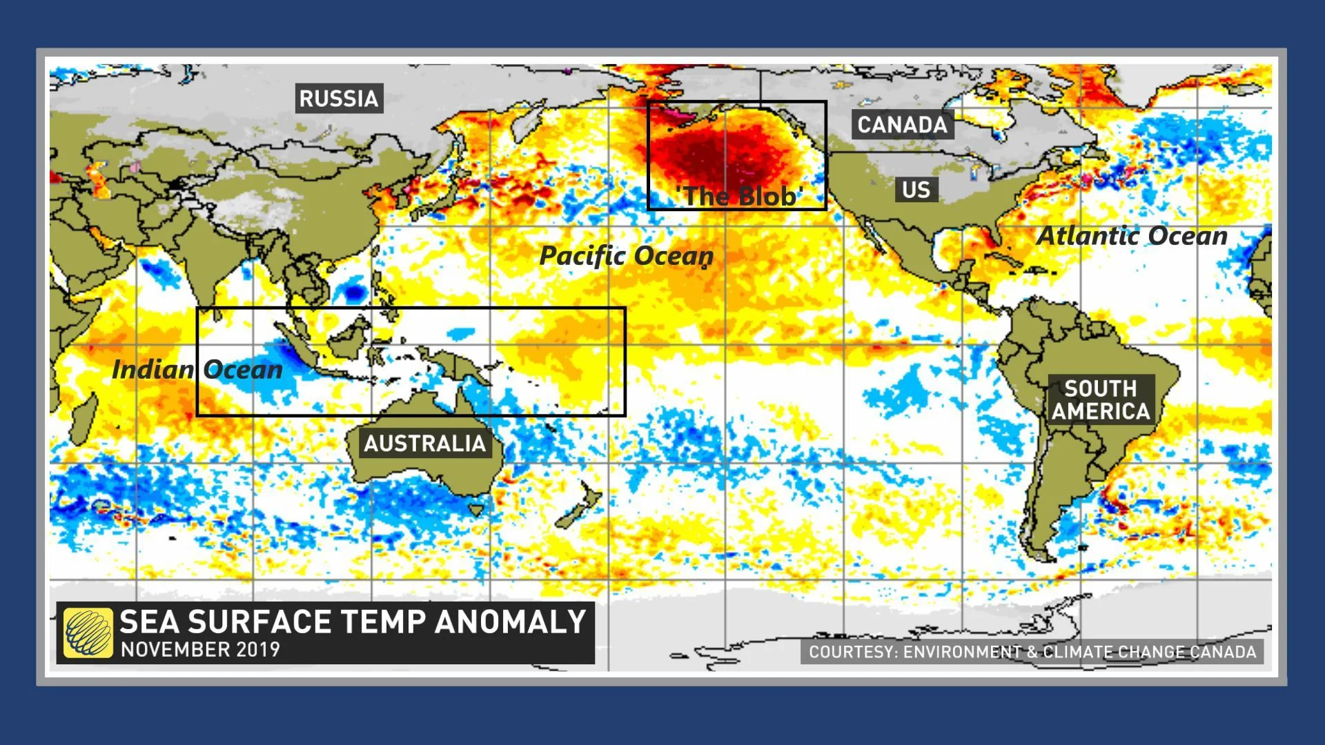
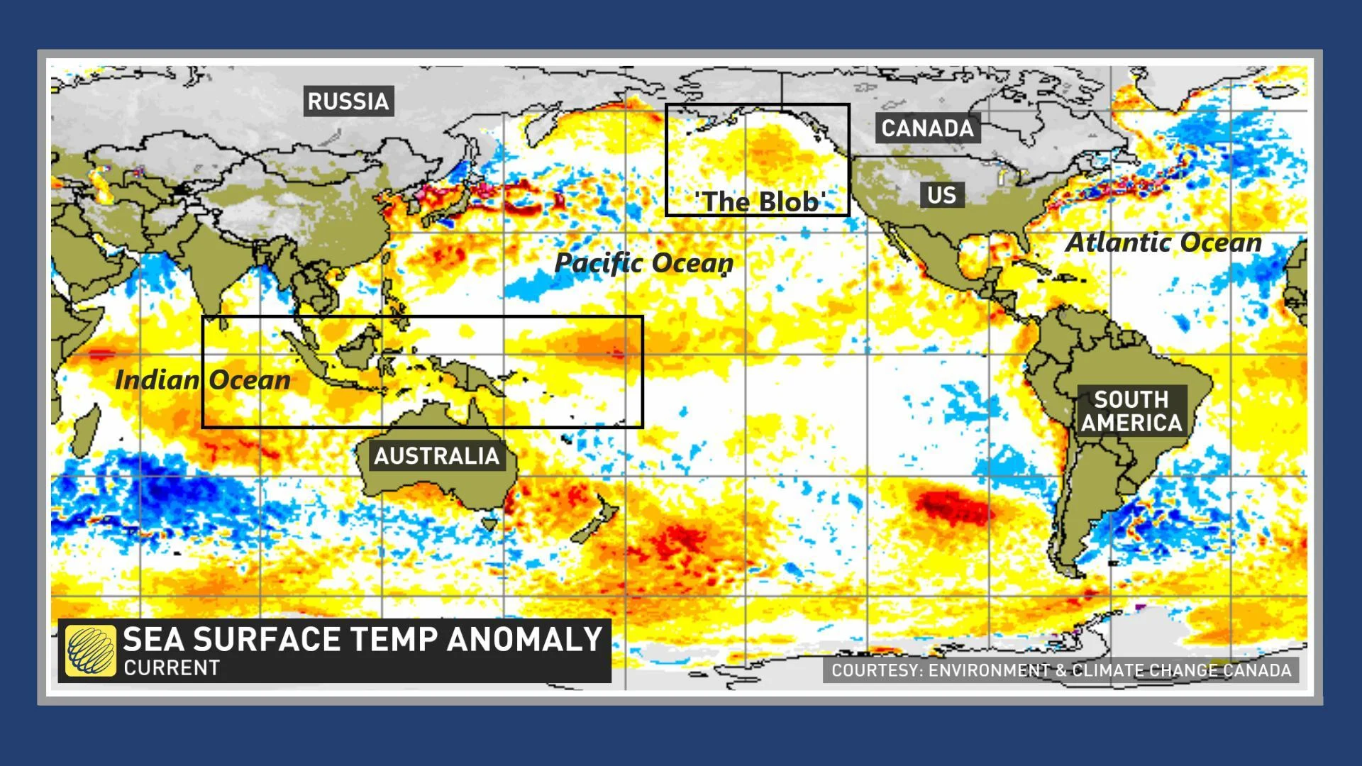
That is comparable to what happened to our winter forecast. A couple of the key drivers of the anticipated winter pattern are no longer with us. Major and unexpected changes in the sea surface temperature pattern have occurred in two key regions. The large region of unusually warm ocean water in the North Pacific -- often referred to as “the Blob” -- that was so prominent through the fall has just about completely faded. When the warmer water is present in this region, it can contribute to the jet stream tracking well to the north into Alaska and then diving south east of the Rockies, delivering arctic air to the Prairies and Great Lakes region.
RELATED: Pacific Blob behind the death of millions of birds
The first map below shows the ocean water temperature pattern that we had when we released our winter forecast. The second map shows our current pattern.
LIMITED SUPPLY OF ARCTIC AIR ACROSS CANADA
The even more problematic change during the past few months has been the warming of the ocean water temperatures across the eastern Indian Ocean, north of Australia and extending into the western Pacific. This has greatly contributed to extended periods of widespread convection (rising air) across this region. History shows us that when this occurs during the winter, the focus of any cold weather usually ends up across western Canada and milder air will surge north across the eastern United States and into adjacent parts of Canada.
Finally, the polar vortex has been very strong and organized this year. This was expected and part of our forecast and reason for calling for northern Canada to see a colder winter compared to many recent years. However, what we didn’t expect was that the polar vortex would spend so much time on the other side of the North Pole – across Siberia. A strong polar vortex on the other side of the North Pole has contributed to periods with a limited supply of arctic air across Canada.
While winter has not been as cold as expected across much of central Canada, we do not expect an early arrival to consistent spring weather. We expect that winter will still attempt to make a strong finish during February and into March.