Eastbound winter storm may wreak havoc on roads across the Prairies

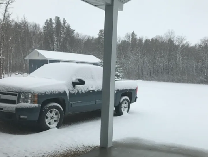
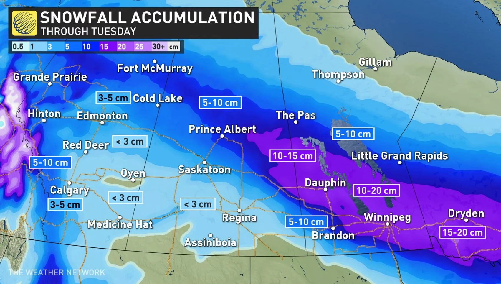
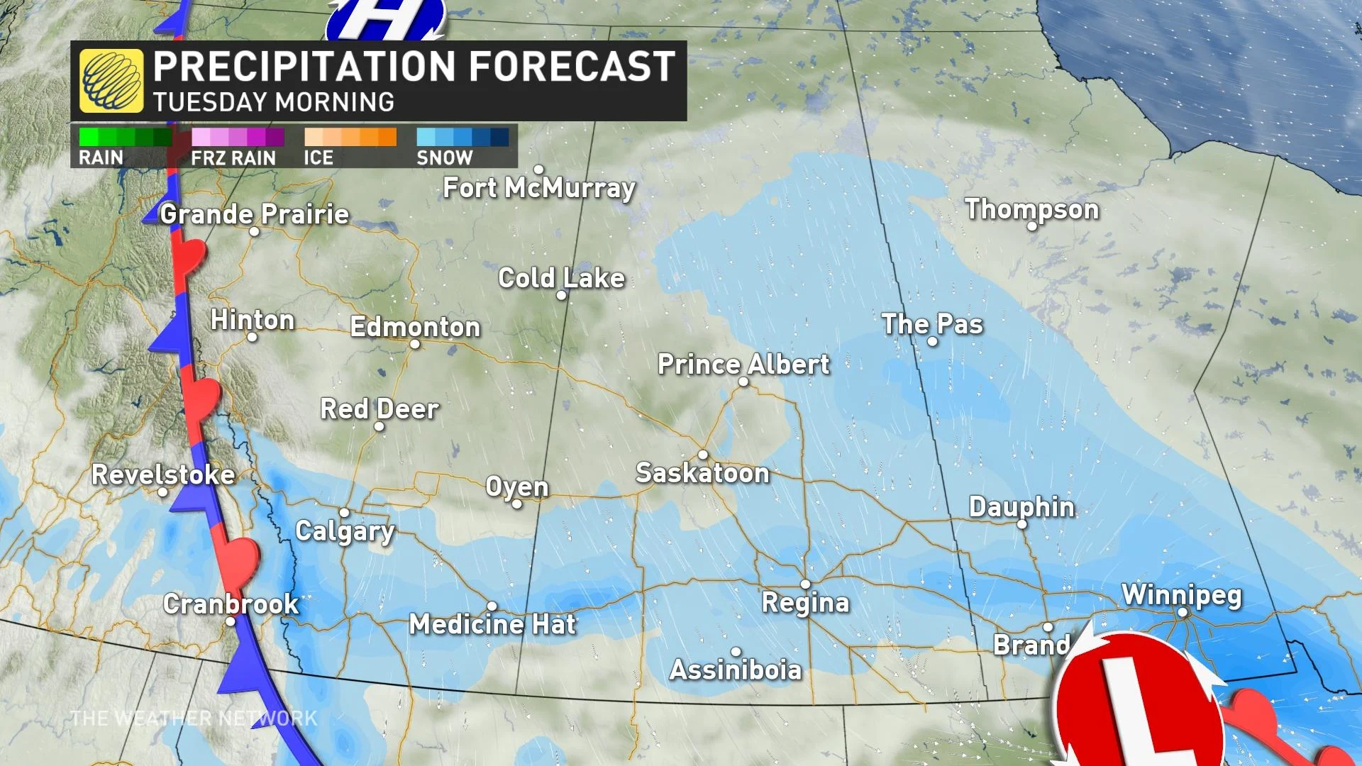
The Prairies will be experiencing a cold week, filled with periods of snow and blustery winds as it progresses. A clipper will bring blowing snow and howling 70-90+ km/h winds across the region through Tuesday, dropping 5-20 cm of snow for parts of Saskatchewan and Manitoba. Low visibility from blowing snow will make travel treacherous across the two provinces, with icy roads in Alberta also impacting commutes. A province-by-province breakdown of the impending winter storm, below.
ALBERTA: SNOW, SHARP TEMPERATURE DROP MAY BRING FLASH FREEZE
Freezing rain and snow greeted the start to the Monday commute across central Alberta as the clipper system got its act together across the province.
Snow will continue for areas in the south throughout Tuesday morning before tapering off. Roughly less than 5 cm is expected.
The surge of cold air will cause a precipitous temperature drop through Monday overnight, leading to a flash freeze of any standing water on roads. Use extreme caution when traveling.
SASKATCHEWAN: POTENTIAL BLIZZARD CONDITIONS MONDAY NIGHT INTO TUESDAY
The clipper continues to make its way east into Saskatchewan. The combination of high winds and snow could lead to a period of blizzard conditions, which are likely Monday overnight into early Tuesday morning.
Winds will be gusting 70-90+ km/h and will be accompanied by snowfall around the cities of Saskatoon and Regina. The low visibility will affect travel along Highway 11 and the Trans-Canada Highway.

A winter storm watch is in effect for most of southern Saskatchewan ahead of the snowfall and winds, with a likely upgrade to a winter storm warning throughout the overnight hours Monday.
Central areas in the province can expect 5-10 cm of snow, while areas in the south will see less than 5 cm. A general swath of 5-10 cm of snow will fall across central Saskatchewan, with higher totals closer to the Manitoba border.
MANITOBA: TUESDAY STARTS WITH BLOWING SNOW
Snow will reach Manitoba on Monday night. Snowfall warnings are in effect for much of southern Manitoba ahead of the potential for 10-20 cm of snow through Tuesday morning. The area of greatest snowfall accumulations will cover Dauphin, Winnipeg, and the Manitoba lakes.
Dangerous travel is likely across the province during the day on Tuesday. Gusty winds will accompany the snowfall into Manitoba, as well, leading to periods of low visibility during blowing snow.
BEYOND THE CLIPPER: FRIGID TEMPERATURES COVER THE PRAIRIES
A blast of frigid Arctic air moves in mid-week, with clear skies and bright sunshine on Wednesday. The daytime highs will only reach into the -20s in Saskatoon, Regina, and Winnipeg, with lows by Thursday morning bottoming out in the -30s. Gusty winds will make the air feel even colder.
Temperatures will moderate for Alberta and Saskatchewan by the end of the week, with the coldest temperatures sticking around in Manitoba heading into the weekend and early next week. Impressive contrast in temperatures West versus East. A clipper will move in late this week, but no major storms in sight after the current system in the short range
Check back for the latest updates on conditions across the Prairies.