Sunshine and warm temperatures—is this Canada's ideal summer forecast?

El Niño was the key to our winter (or lack thereof) during the past year, but the global pattern is in a state of upheaval once again. Here's what that means for Canada's 2024 summer.
Sunshine and warmth are what many Canadians dream about as we look forward to summer. Now that we are on the doorstep of summer, are those dreams about to become a reality?
According to The Weather Network’s summer forecast for the months of June, July, and August, most of Canada will see warmer-than-normal temperatures, fewer rainy days than the typical summer, and more sunshine than normal during the upcoming season.
That forecast might be just what you are hoping for if you have plans to be by a lake or pool for much of the summer. However, there is a catch.
Too much heat brings many risks, and without regular rain, we end up with drought, a heightened risk for wildfires, and poor air quality. All of the above are also concerns during the upcoming season.
Here is a look at our national temperature forecast:
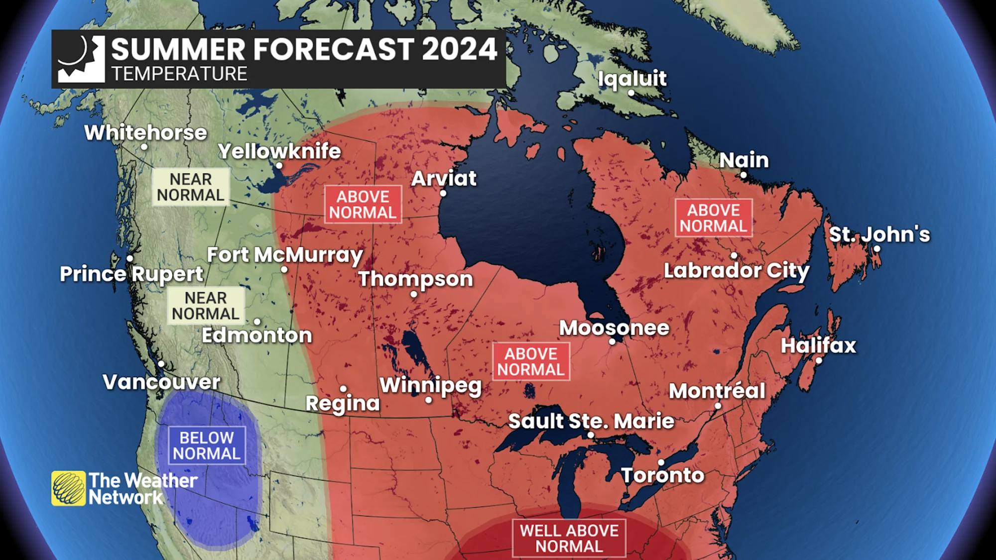
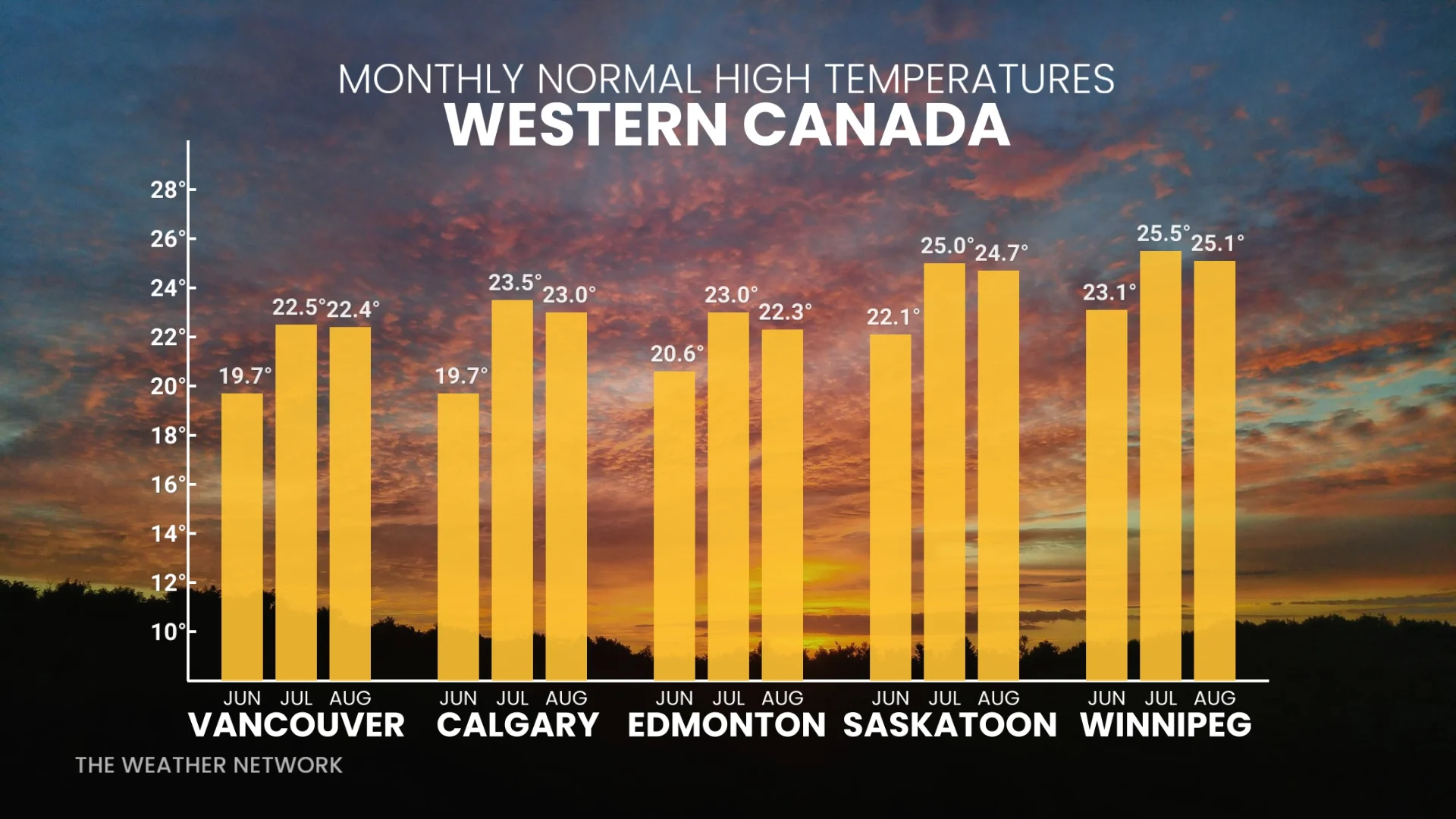
Western Canada is the one region where we expect more of a typical summer, but a “normal” summer will still include periods of hot weather.
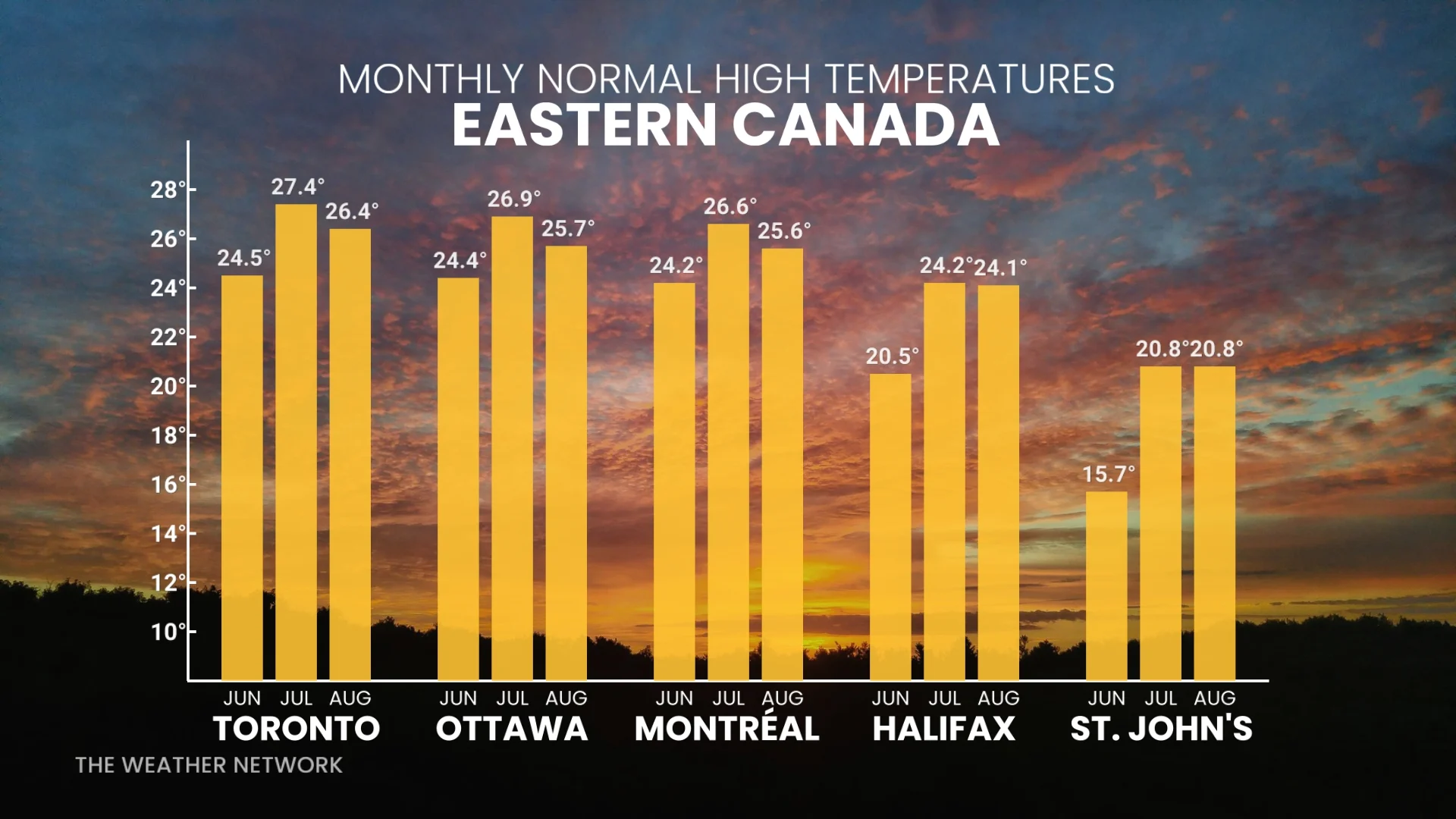
From the central Prairies to Atlantic Canada, we expect warmer than normal temperatures this summer, but June will still include periods of cooler weather. The heat will peak during July and August, with a heightened risk of extended heat waves.
Most of Canada can expect to see near-normal or below-normal rain totals for the season.
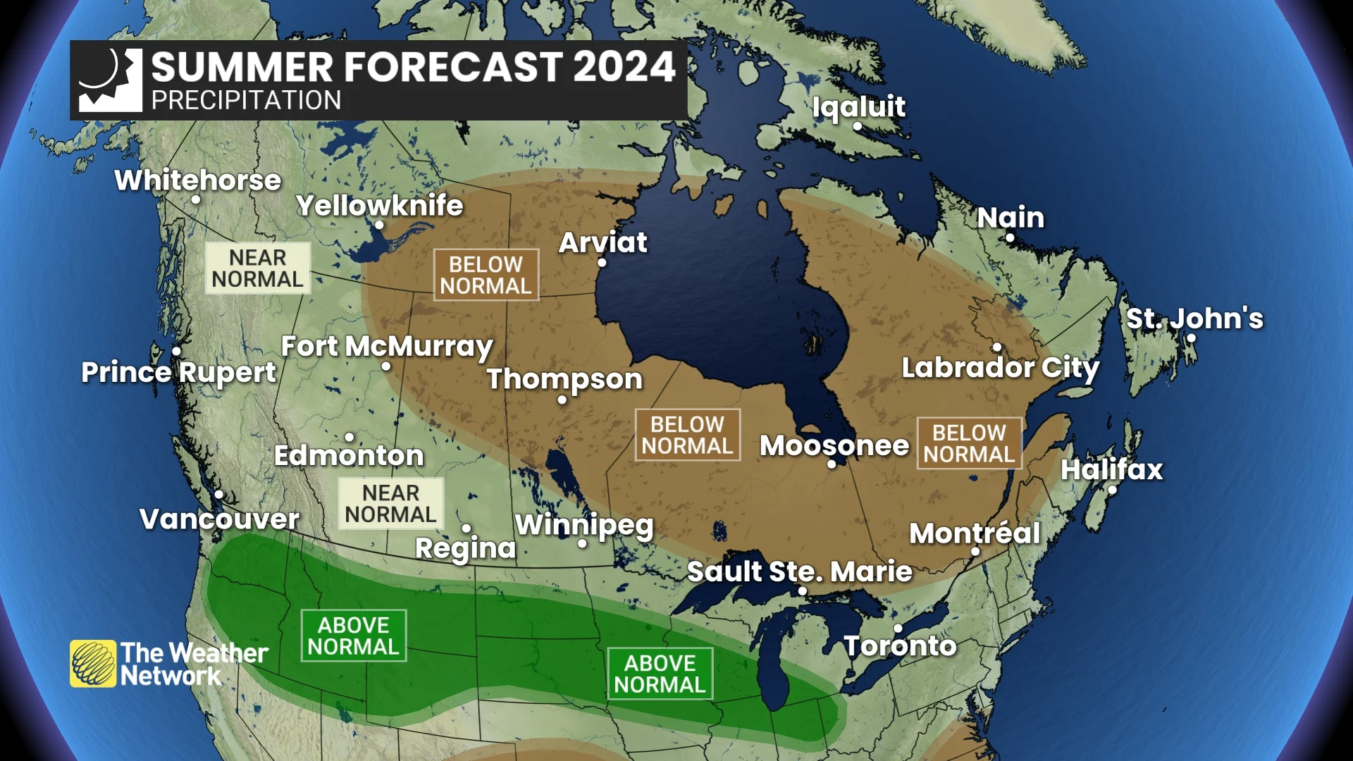
However, a more active storm track south of the border will shift north at times and impact southern Canada. Also, the heat will also increase the risk for powerful thunderstorms at times and for wind and hail damage.
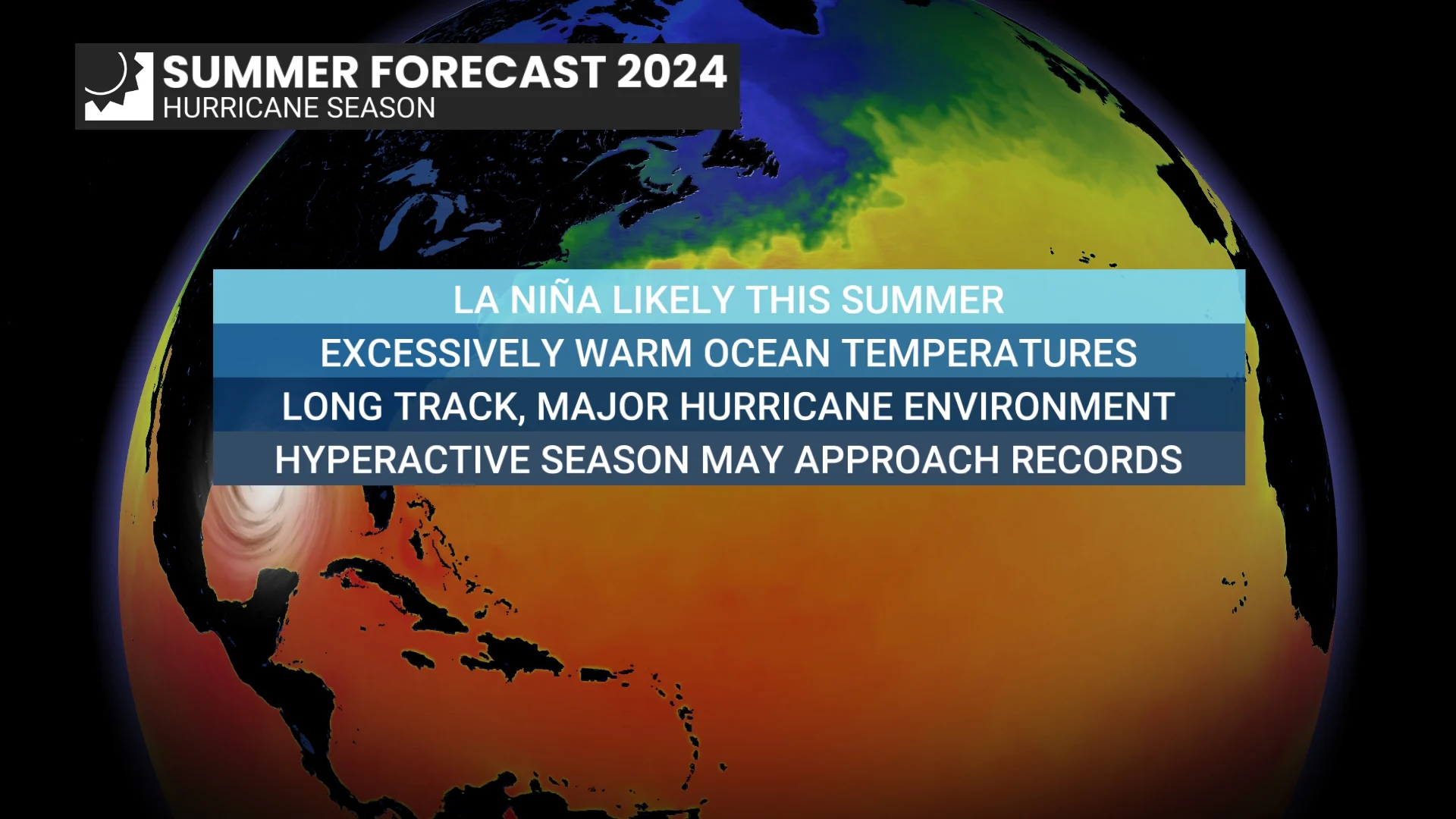
In addition, a very active hurricane season is expected in the Atlantic.
WATCH BELOW: 2024 Atlantic hurricane season outlook
A familiar pattern with a twist
El Niño was the key to our winter (or lack thereof) during the past year, but the global pattern is in a state of upheaval once again. We are seeing a rapid transition back to La Niña conditions, which feature cooler than normal ocean water temperatures in the tropical Pacific.
RELATED: What is La Niña? And how does it impact global weather?
Looking back at previous summers, which featured a rapid transition from a strong El Niño to a La Niña, we find that those summers were often associated with cooler and wetter weather across western Canada.
La Niña conditions were in place for three consecutive years prior to this past year, so we are going back to a familiar pattern.
However, this La Niña event is currently developing in a way that is unlike any previous La Niña event. So, we are not assuming that the associated weather will be the same as what we have seen in the past.
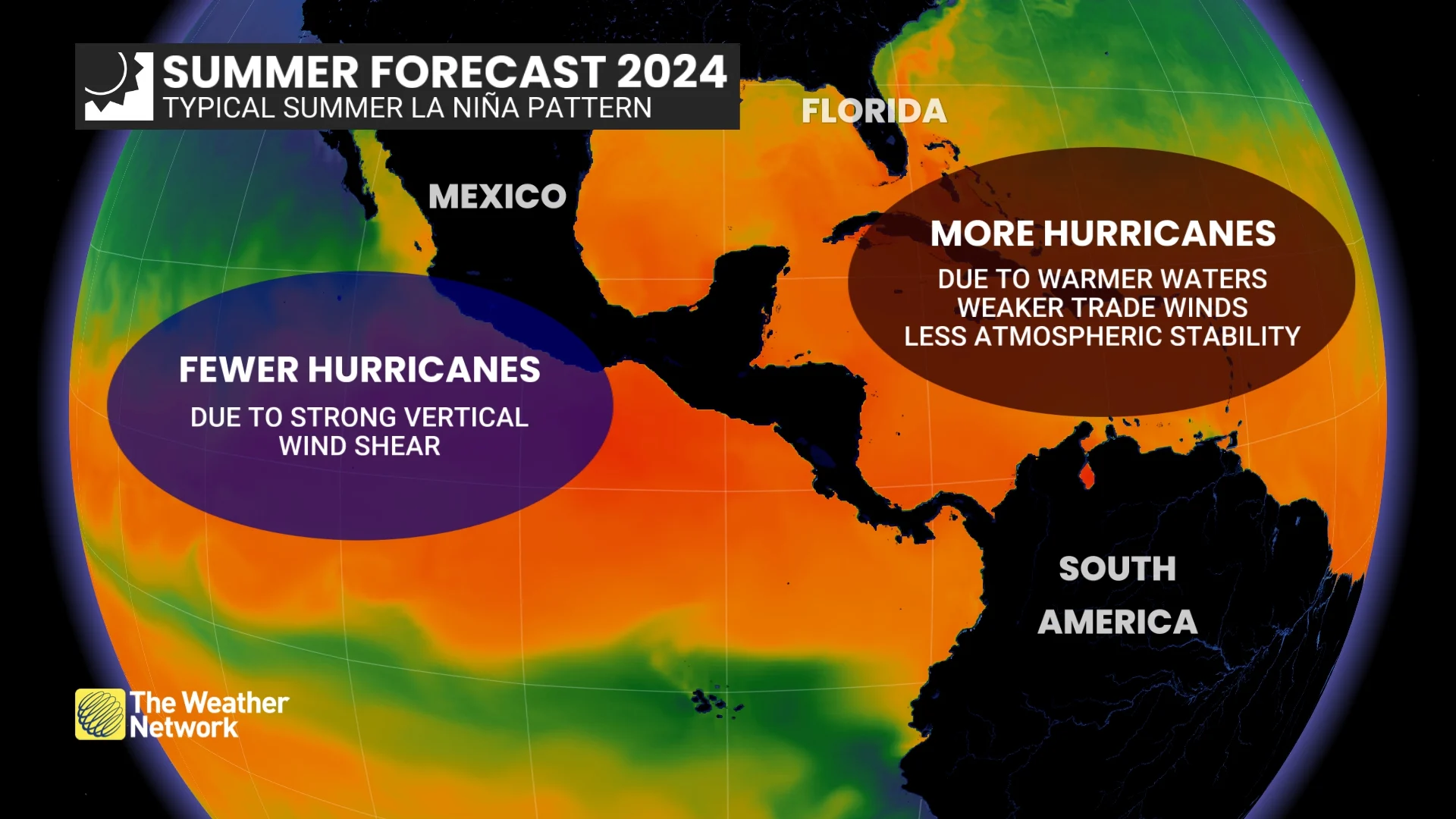
Typical hurricane pattern in a La Niña year (The Weather Network)
Below is a more detailed look at what we can expect across the country during the upcoming summer season.
British Columbia
A typical summer is expected across the province, including Vancouver and Victoria. This means that there will still be periods of hot weather, especially across the interior, including Kelowna and Kamloops. However, the heat should be less persistent and less severe than it has been during recent summers.
This summer will also bring the typical periods of dry weather, but scattered showers and thunderstorms are expected to be more numerous and widespread than they have been during the past few summers.
Despite the additional opportunities for beneficial rain, wildfires will still be a major concern during the summer, along with days with smoke and poor air quality as lightning from storms can ignite fires.
WATCH: How conditions could impact B.C.'s wildfire season
Alberta
A warm summer is expected across the province, including Edmonton and Calgary, but we expect less extreme and persistent heat than we have seen during recent summers.
Drought is still a major concern this summer, especially across northern areas, including Fort McMurray, but May brought substantial relief from the very dry conditions. Therefore, we are entering the summer in much better condition than the past few summers.
An active storm track south of the U.S. border is expected to shift north at times. Therefore, powerful storms should interrupt extended periods of dry weather and bring rain totals to near-normal for the summer season.
Wildfire smoke will continue to be a major concern at times during the season, but at this point, air quality is not expected to be as poor as it was last summer.
WATCH: Could the summer storm track improve drought conditions across the Prairies?
Saskatchewan and Manitoba
A very warm summer is expected across the region, including Saskatoon and Regina, with a risk of extended periods of hot weather at times, especially across southern Manitoba, including Winnipeg.
We are starting the growing season with much wetter soil conditions than last year thanks to the widespread rain during May, but extended periods of dry weather are expected at times during the summer.
An active storm track south of the U.S. border is expected to shift north at times and bring powerful storms to parts of the region. This should help to break up the extended periods of dry weather and bring rain totals to near normal for the season. Nevertheless, wildfire smoke will continue to be a concern at times during the season.
Ontario
A hot and humid summer is expected across the province, including the Greater Toronto area and Ottawa. This will bring a heightened risk for extended heat waves, especially across southwestern Ontario, including Windsor and London. We will see periods of cooler weather during June, but the heat will build through July and August and linger into September.
After a wet spring, we are starting the summer well-watered across most of the agricultural regions. However, as we get deeper into the summer season, extended periods of dry weather are expected, especially across northern Ontario, with a high fire danger and a risk for poor air quality from smog and smoke.
However, the heat will also help to fuel powerful storms, with a heightened risk for strong to severe storms at times.
WATCH: Hot, dry season brings wildfire risk to parts of Ontario
Quebec
A hot and humid summer is expected, with a risk for extended heat waves, especially across the southern and western parts of the province, including Montreal. We will see periods of cooler weather during June, but the heat will build through July and August and could linger into September.
Most of the province had a wet spring, so we are heading into summer with a lower fire danger than this time last year. However, as we get deeper into the summer season, extended periods of dry weather are expected, with an increasing fire danger and a threat of poor air quality.
However, the heat will also help to fuel powerful storms, with a heightened risk for strong to severe storms at times.
We will also keep a close eye on the tropics, as an active season is expected and the remnants of a tropical system could bring beneficial or excessive rain to parts of the province later in the summer or fall.
WATCH: Will La Niña mean a stormier season across Quebec?
Nova Scotia, New Brunswick, and P.E.I.
A very warm and humid summer is expected across the region, including Halifax, Fredericton, and Charlottetown, but periods of cooler weather are likely, especially during June and early July. The heat will peak during late July and August and could linger into early September.
Extended periods of very dry weather are likely, but we will be closely monitoring the tropics as a hyperactive hurricane season is expected, and a couple of those storms could impact the region and bring rain totals close to normal for the season and even a risk for excessive rain.
WATCH: How will La Niña impact the Atlantic Canada region?
Newfoundland and Labrador
A warm and humid summer is expected across the province, including St. John’s and Corner Brook, but periods of cooler weather are likely at times, especially during June and early July.
Extended periods of very dry weather are likely, but we will be closely monitoring the tropics as a hyperactive hurricane season is expected and a couple of those storms could impact the region and bring rain totals close to normal for the season, and even a risk for excessive rain.
RELATED: New to the East Coast? Here’s how to prepare for hurricane season
Northern Canada
A warm summer is expected across western Nunavut and the eastern Northest Territories, including Yellowknife, and near-normal temperatures are expected elsewhere across the region, including Whitehorse and Iqaluit.
Dry conditions will continue to be a major concern across much of the region, especially across western Nunavut and the eastern NWT. Wildfires, smoke, and poor air quality will be a major concern once again across the region this summer.