See the sastrugi, and other weird winter phenomena
Certain weather phenomena only emerge in these prolonged periods of deep cold, and thanks to the blast of Arctic air sweeping most of Canada and much of the United States at the moment, we're starting to see some of those occur.
Much of North America is in the grip of mid-winter cold, the weather is starting to get weird.
Certain weather phenomena only emerge in these prolonged periods of deep cold, and thanks to the blast of Arctic air sweeping most of Canada and much of the United States at the moment, we're starting to see some of those occur -- and, fortunately for those of us who don't want to brave the cold ourselves (like me), there are lots of people out there taking pictures of them.
From sastrugi to steam devils, let's take a look at some of the strange weather being spotted out there.
(Related: The six freakiest kinds of winter weather)
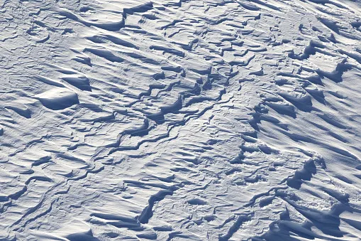
SASTRUGI
This Upstate New York field is doing a convincing impression of rolling ocean waves, but that's snow drifting across the plain.
Snow waves, or sastrugi as they're formally known, do form the same way their water-based cousins do -- when wind blows across the surface and pushes loose snow particles into drifts perpendicular to the wind's direction. Watching in real time wouldn't give you the same effect, but the sped up time lapse footage shows how the waves traveled over the course of the morning and early afternoon. Sastrugi are also common over sea ice, and are familiar features on the Antarctic landscape.
STEAM FOG
If you've been driving in the vicinity of the Great Lakes or other large bodies of water since the cold snap started, you might have spotted this haze drifting above the surface.
Even though the open surface of Lake Ontario is only a couple of degrees above freezing, that is still steam rising off the water, also known as 'sea smoke'. Air with temperatures in the minus teens and 20s is cold and dry enough that vapour in the saturated layer of air just above the water's surface condenses out when the wind stirs. It's the same mechanism that makes the steam that rises above your bathwater -- albeit under (hopefully) much colder conditions than those in your bathroom.
STEAM DEVILS
There are a lot of whirls in the 'devil' family, and these are perhaps some of the most unusual. Steam devils form under the same conditions as steam fog, when cold out over relatively warmer water generates steam, and some of that steam is drawn into a vortex that has formed over the water.
The vortices generally form when the difference between the water temperature and the over-riding air is quite pronounced -- not unlike what we've seen in the Great Lakes region and over the coastal U.S. Northeast the past few days. When the air is much colder than the water, the setting is much more unstable, with the warm air lurking above the water rising more quickly; not unlike the conditions that favour the formation of tornadoes on land.
SLUSH BALLS
A slightly more common sight around the shoreline, at least in cold winters, slush balls are also making their return to the Great Lakes.
These squishy snowballs form the same way you'd roll up a snowman, except in this case it's the wave action rolling snow on the water's surface into clumps. They typically begin as small chunks of ice floating on the surface and grow in size as waves sweep them repeated through snow floating on the surface. When the waves finally push them ashore, they tend to freeze fully and line the water's edge with little ice boulders.