A bird's-eye view of the Ottawa River's destructive flooding
Transport Canada photos show the extent of flooding across the region
The Ottawa River is at levels never seen in its recorded history in places, swamping neighbourhoods and flooding homes.
Transport Canada flew a plane over the region on April 29 to get an overview of the flooding along the river.
The images below show the extent of flooding in many of those communities.

The Chaudière Falls are seen from the air. (Transport Canada)

Ottawa's Britannia neighbourhood, where waters are expected to peak on Thursday, is seen from the air. (Transport Canada)

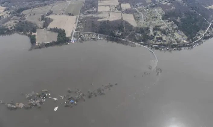
Constance Bay in Ottawa's rural west end is seen from the air. Much of the area has since been evacuated because flood waters have risen. (Transport Canada)

The paths near Parliament Hill have been completely flooded and closed by the National Capital Commission. (Transport Canada)

The National Capital Commission has closed all access to Bate Island because of the rising waters. (Transport Canada)

The Hull Marina in Gatineau, Que, is under water. (Transport Canada)

Homes in the Pointe-Gatineau neighbourhood have been consumed by the flood waters. (Transport Canada)

Petrie Island in Ottawa's east end is essentially underwater. (Transport Canada)

Homes in the Clarence-Rockland, Ont., area east of Ottawa are being surrounded by rising river water. (Transport Canada)
This article was originally published by CBC News.