Hay River mayor confident in firefighters' ability to defend the community
Visit The Weather Network's wildfire hub to keep up with the latest on the unprecedented wildfire season across Canada.
Despite unfavourable conditions in the coming days, Hay River Mayor Kandis Jameson says she's confident in firefighters' ability to "defend our community."
"Personally, I'm feeling a lot more comfortable than where we were a week ago," she said.
Looking ahead, strong winds, hot weather and low humidity are expected for most of the N.W.T.'s South Slave region — a combination that could lead to significant fire activity.
"Temperatures are forecast as high as 28 C going into the weekend," reads an update shared by the town to social media Tuesday morning. "The fire remains eight kilometres to the south of Hay River proper. Structural protection continues to be put in place in [Kátł'odeeche First Nation] and there is no risk for that community at this time."
RELATED: Through doorbell cameras, West Kelowna residents witnessed their homes burn
Like most of the region, Hay River, located about 200 kilometres south of Yellowknife, was forced to evacuate due to wildfires burning close by more than a week ago.
Since then, officials have declared a territory-wide state of emergency, Yellowknife has also evacuated and roughly 26,000 N.W.T. residents — more than half of the territory's population — have been displaced due to wildfires.
Jameson said reinforcements have arrived in her community, including from the Canadian Armed Forces.
"That's a huge asset," she said.
WATCH: Huge wildfire smoke plumes blanket sky in Northwest Territories
SEE ALSO: Despite rain in Yellowknife area, fire threat remains
Cooler temperatures, scatterings of rain and lighter winds over the weekend gave crews an opportunity to do more preparation work.
"Bombers were going late yesterday, it sounded like a war zone out there," said Jameson. "Fingers crossed they have everything in place."
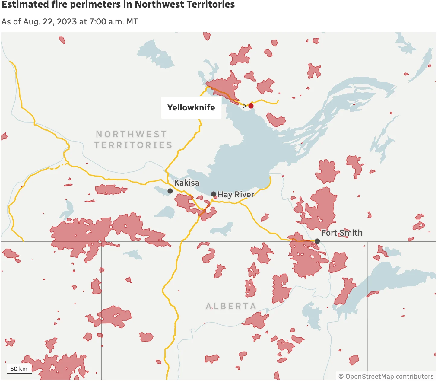
Estimated fire perimeters in Northwest Territories as of Aug. 22, 2023 at 7:00 a.m. MT (Source: Natural Resources Canada via CBC)
Communications services in the community also recently returned after wildfires caused a widespread outage.
Andrew Anderson, spokesperson for Northwestel, said there is still no service in Kakisa and Jean Marie River.
"Telecommunications services are functioning in all other South Slave communities and technicians are on the ground working to restore disrupted services as quickly as is safe to do so," he said.

A satellite view of the wildfire's proximity to Fort Smith, N.W.T., on Aug. 20. (Sentinel-2/European Space Agency)
This is Hay River and Kátł'odeeche First Nation's second evacuation this summer due to wildfire, and third evacuation in two years; last year's was caused by flooding.
"Everybody's stressed and it's unheard of to think of what we have gone through in the past few years," said Jameson.
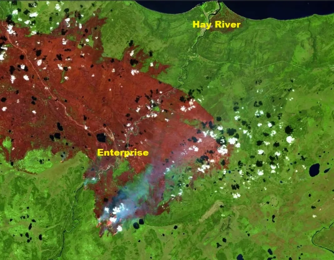
A satellite view on Aug. 20 of the wildfire that tore through the hamlet of Enterprise, N.W.T., and is threatening Hay River. (Sentinel-2/European Space Agency)
Like Hay River, crews in Fort Smith, which is located about 300 kilometres southeast of Yellowknife, near the Alberta border, also expect to have to defend the community in the coming days.
Mike Westwick, fire information officer with the territorial government, said there was a possibility that the wildfire burning about four kilometres outside of Fort Smith reaches the community in the coming days.
But he said crews have set up control lines leading to natural firebreaks and extensive sprinklers systems.
In an update shared Tuesday morning, Parks Canada said it was planning controlled burns south of Highway 5 about 11 a.m., pending conditions. It added that residents may see smoke as a result.
WATCH: Yellowknife evacuee recalls escaping city through fire and smoke
SEE ALSO: Southern N.W.T. crews gear up for challenging conditions that could fuel fires
In a separate update, the agency addressed the location of the fire.
"We recognize that this distance has not changed in the last week or so and we would like to stress that this wildfire is still a significant threat," it read. "Crews have worked tirelessly along the northern flanks with helicopter bucketing, strengthening dozer guards and direct attack to try to stop its spread north."
"We're battling so many battles on so many fronts," said Westwick.
This article, written by Francis Tessier-Burns, was originally published for CBC News. Contains files from Hilary Bird.