PHOTOS: Downed trees and huge hail with tornado-warned storms in Ontario

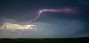
Severe thunderstorms swept through parts of southern Ontario and Quebec Wednesday, with reports of heavy rain, damaging winds, and large hail through the afternoon and evening hours
The threat for severe thunderstorms spanned much of southern Ontario, and Quebec on Wednesday, as a soupy, tropical air mass helped to fuel the unstable conditions.
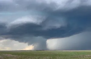
By 2 p.m. ET, the first of the tornado warnings were already covering parts of Ontario's cottage country, including the city of Orillia, Bracebridge, and Gravenhurst. Additional tornado warnings, and severe thunderstorm watches and warnings lined the region through the evening and overnight hours.
MUST SEE: Watch? Warning? How we communicate severe weather in Canada
Damaging winds, heavy rain, frequent lightning, and large hail accompanied Wednesday's storm threat, with reports of three inch-sized hail in areas from Talbot up to Coboconk, Ont.
Power outages and downed trees were also reported amid the stormy conditions, with the largest swath of outages affecting customers north of Barrie and Orillia. Before the dinner hour, more than 30,000 were left in the dark, and outages continued well into the night.
This was the third consecutive day with a looming storm risk, but with the most severe conditions threatening the region Wednesday. That's as a cold front and low pressure system sliced through the hot and humid air mass that had been building over the past five days.
The thunderstorm risk will continue across parts of Quebec on Thursday as the storm system pushes eastwards, so be sure to stay weather-aware, and up-to-date on all of the watches and warnings in your area.
Here's a closer look at Wednesday's storm as it erupted over social media: