Microbursts can turn a gentle storm into a harrowing ordeal

A run-of-the-mill summertime thunderstorm can turn violent in a hurry when a microburst sends destructive winds tearing through your neighbourhood.
Everything appeared normal as a sleek airliner sliced through the soupy air stewing over Dallas on August 2, 1985.
Delta Air Lines Flight 191 from Miami was one of hundreds of flights bound for Dallas-Fort Worth on that midsummer afternoon. First Officer Rudy Price navigated the jetliner through a bubbly sky on its descent to the runway.
Price glided the aircraft into a thunderstorm as the flight approached the airport. A minute before landing, a sudden wind shift pushed down on the jet and caused the plane’s airspeed to rise. The first officer pulled the plane’s nose upward to make up for this dramatic change.

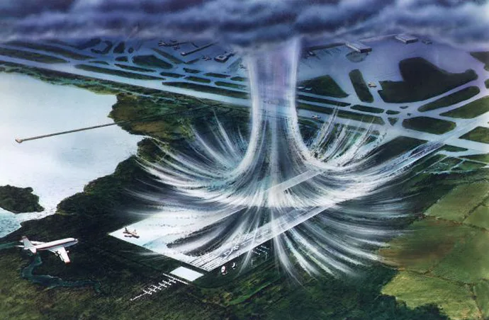
Illustration of a microburst along an airplane’s landing path. (Courtesy of NASA)
In the blink of an eye, the headwind abruptly swirled around to a strong tailwind, causing the plane’s airspeed to plummet as fast as it climbed seconds earlier. Flight 191 lost too much speed and altitude for Price to regain control, and the aircraft crashed almost 2 km from the runway, killing 136 of the 163 souls aboard.
The airplane flew into a microburst, or a sudden rush of winds that fell out of the base of the thunderstorm and smacked into the surface with terrifying force.
That tragic plane crash in Dallas sparked a dash among scientists and officials alike to study microbursts and learn how to better detect and keep people safe from these hidden summertime threats.
DON'T MISS: Don’t fall victim to these seven dangerous tornado myths
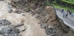
Microbursts are a major cause of wind damage in severe storms
Damaging winds in thunderstorms are divided between straight-line winds, which all blow in one direction, and tornadoes, which rapidly rotate over a much smaller area.
Thunderstorms that produce straight-line winds can lead to greater and more widespread damage than a tornado, a fact anyone who’s witnessed a derecho knows firsthand.

Most straight-line winds are caused by downbursts, or large columns of air that sink out of a storm and spread out when they hit the ground.
A microburst is just a small-scale downburst, one that affects an area spanning less than 4 kilometres. Think of a microburst like a balloon of cool air that falls out of the base of a thunderstorm and smacks into the ground below, quickly dispersing from the point of impact in all directions.
Microbursts form several different ways, and the type of microburst you might see from a vigorous thunderstorm usually depends on where you are.
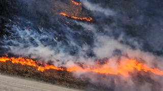
Wet microbursts are common on sticky, humid days
Folks in humid areas like Eastern Canada are likely to see a wet microburst during a thunderstorm. These microbursts form during high-precipitation storms with driving rainfall pouring from storms that bubbled up on a hot and steamy day.
Sometimes, the powerful updraft that feeds a thunderstorm will suddenly weaken, leaving an enormous amount of rain suspended in the middle of the storm.

Lacking the support needed to keep all that rain suspended, the water all falls to the ground at once, dragging a rush of cold air along for the ride. This process, called water loading, is one way we can see a wet microburst during a storm.
Another way is through dry air entrainment, or the intrusion of dry air into the centre of a thunderstorm. Rain suspended in a storm can begin to evaporate when dry air starts mixing in with the updraft.
Evaporation is a cooling process—which is why we sweat on a hot day!—so the sudden evaporation of that suspended rainfall creates a large area of cooler, denser air in the storm. This cold air starts to sink toward the ground, picking up speed as it falls until it smashes into the surface and creates winds that can exceed 120 km/h in some cases.
WATCH: Security video shows how fast a microburst’s winds can start howling
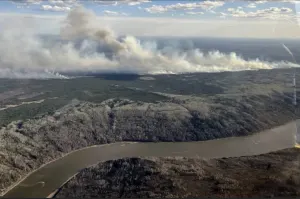
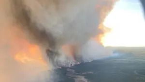
Dry microbursts are common in deserts and on the Prairies
Thunderstorms that form in drier climates, such as the Prairies and desert areas, are often starved for moisture. The main threat posed by these dry thunderstorms is usually lightning that can spark prolific wildfires, but dry microbursts are also a major hazard.
The term “dry” thunderstorm is a bit of a misnomer. There’s usually a decent amount of rain falling from the storm—it’s just that hardly any of it reaches the ground. Thunderstorms in dry climates form higher in the atmosphere than storms in more humid parts of the world.
Rain falling from such a storm often runs into a thick layer of dry air between the storm and the ground. This rain quickly evaporates, leading to a rush of cold air sinking toward the ground. The resulting microburst can go unnoticed if not for the dust and debris getting scooped up as the wind streaks across the arid surface.
A microburst is a deadly hazard to airplanes on arrival and departure
Safety regulations are written in blood, the old saying goes, and some of the most critical airline safety rules and systems we benefit from today were a direct result of crashes like Flight 191 on that stormy day in Dallas back in 1985.
Dr. Theodore Fujita, creator of the eponymous Fujita tornado rating scale, extensively studied downbursts in the early 1980s. His pioneering research laid the groundwork for meteorologists, engineers, and regulators to make flying safer by helping pilots avoid dangerous thunderstorms.
Today, wind shear alert systems are in place both in cockpits and on the ground at airports to warn pilots and controllers when dangerous shifts in wind speed and direction are imminent. Airlines extensively train pilots on how to handle sudden bouts of wind shear on arrival and departure.
Modern Doppler weather radar sites are also capable of detecting microbursts in their formative stages, giving forecasters some time to issue warnings ahead of potential danger.
Thumbnail courtesy of NASA