Study points to role of stronger winds in hurricane flooding
2019 added to a troubling trend for the Atlantic hurricane season, marking the third year in a row that single storms brought record-breaking rainfall to the United States. Hurricanes Harvey, Florence, and Imelda all caused catastrophic flooding in parts of the south -- a concern for residents and authorities alike, with extreme rainfall events expected to become more common in the coming years.
Until now, many climate models had presented a puzzle for researchers when it came to projecting hurricane rainfall trends.
Most studies conclude that rainfall rates in tropical systems should increase with global warming scenarios, given that warmer air can hold more water vapour. And while many models did show this relationship, the percentage increase was much higher than what researchers expected to see.
SEE ALSO: What's behind the trend of stalling hurricanes
In this study, a Princeton-based team suspected the intensity of a storm's winds might also play a role in spurring rain rates. Observations have shown that hurricanes with stronger winds tend to have higher rainfall rates, even under current conditions. This effect is particularly evident in the 100 km closest to a storm's centre, where higher winds increase the rate at which moisture is drawn into the storm. That enhanced moisture convergence near the storm's core aligns very closely with higher rainfall in that inner portion of the cyclone.
Using a new, higher-resolution model, the researchers isolated tropical cyclones into different groups by strength using the Saffir-Simpson scale -- the one that we use to classify hurricane categories -- instead of looking at all storms together.
Using that methodology, the scientists found results much more in line with the increases you'd expect to see based on the increased moisture alone. The graphs below show the percentage change for the rainfall rate in the 100 km closest to a storm's centre, divided by ocean basin. The red line shows the expected change in water vapour content, based on warmer sea surface temperatures. The black dots show the percentage rainfall increase (or decrease) for each category-grouping of hurricanes.
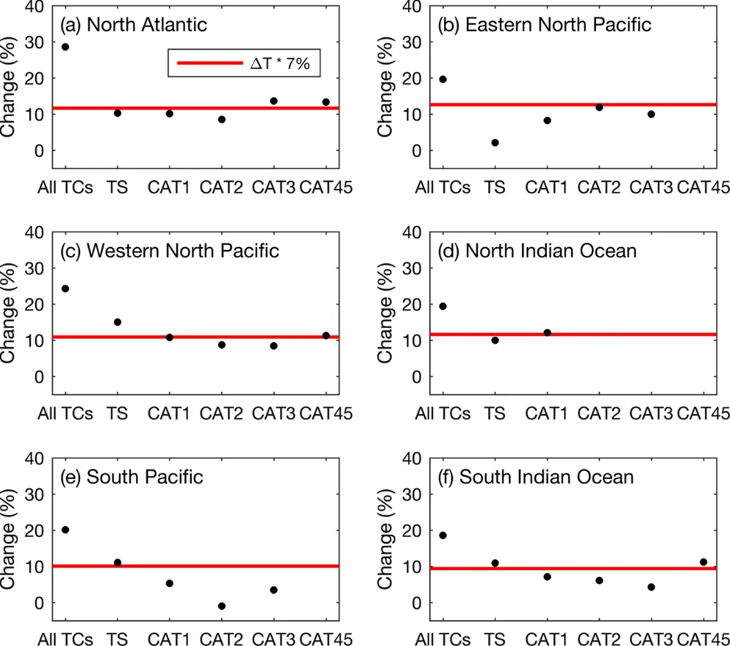
The percentage change of 100-km TC rainfall rate with respect to each category of the Saffir-Simpson TC wind intensity scale (black dots). The red line indicates the percentage change of water vapour content indicated by SST change, assuming a 7% increase in water vapour content per degree Celsius increase in SST in the basin. Only storm categories with sample size >100 are shown. Image courtesy npj | Climate and Atmospheric Science
It's only when you lump all the storms together (the left-most dot on each graph) that you find the abnormally high rainfall rate. That has implications for not just how rainy storms are, but their strength, as well.
RELATED: Changes expected for tropical storms in the Atlantic Basin
"We found that not only did a storm's holding capacity for water vapor increase because of global warming," said the study's lead author, Maofeng Liu, "but also that the storms were getting stronger and contributing to higher rainfall rates."
Another researcher on the team, Gabriel Vecchi, said the study "makes a statement about the future."
"Our observations are starting to show the increased rainfall that our models have been predicting for quite a while," said Vecchi, "and now we also have a clear theoretical understanding as to why it should be happening."


