Two major snowstorms roar across Canada as March arrives in style

The unofficial start to spring arrived with pizzazz this week as an active pattern pumps out one impactful winter storm after another.
“March roars in like a lion,” the proverb goes, and the sky over Canada is breathing life into the old cliche this week as multiple high-impact snowstorms roll across the country.
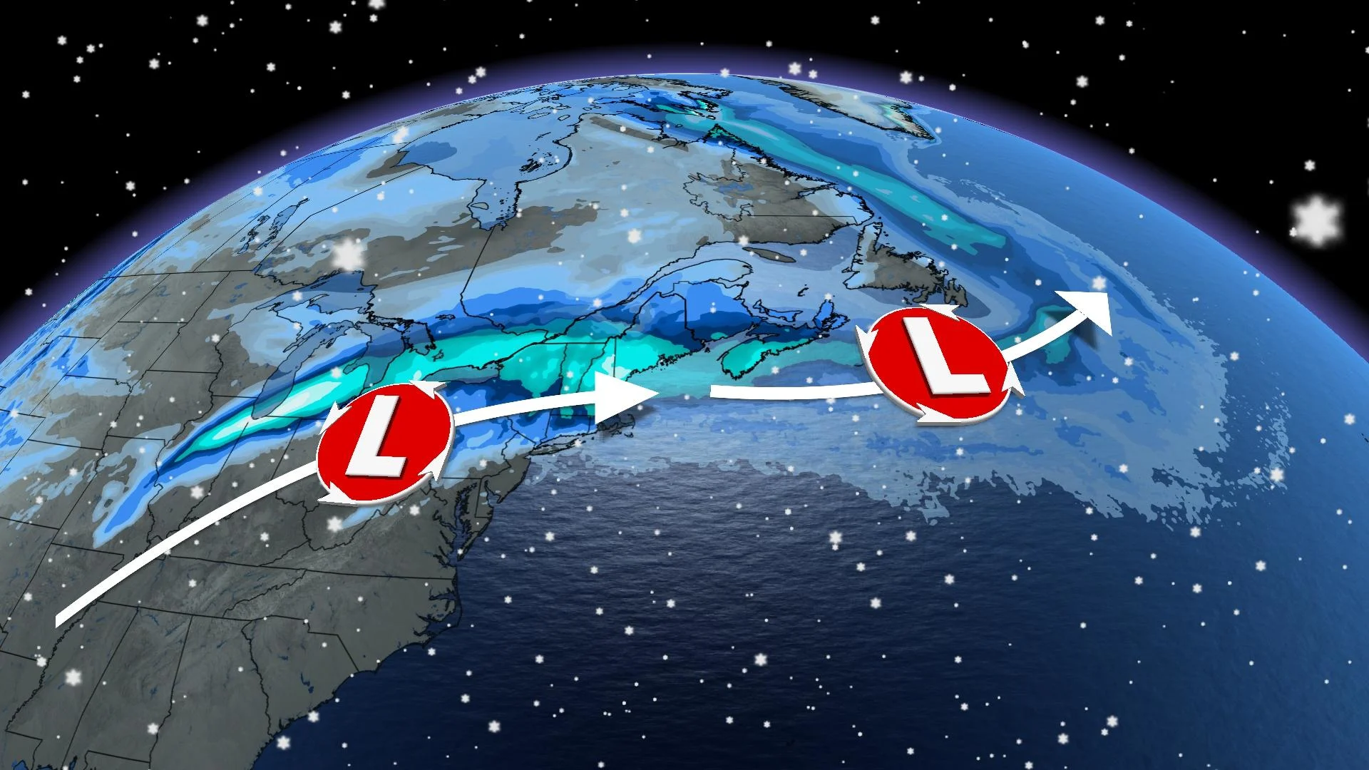
The month begins with two major snowstorms hitting a majority of the country’s population. One storm pelting the East Coast with heavy snow and high winds on Thursday precedes another system with even more energy eyeing Toronto and the nation’s capital to start the weekend.
Both of these storms have roots in the setup that’s led to bizarre weather across the U.S. and Canada over the past couple of weeks.
Visit our Complete Guide to Spring 2023 for an in-depth look at the Spring Forecast, tips to plan for it and much more!
There’s no time for a breather across North America this week as a highly active pattern continues across the continent.
We’ll head into the weekend with many folks across the eastern half of Canada cleaning up from two major snowstorms.

March begins with two major snowstorms
Our first significant storm hit the Maritimes during the day Thursday, bringing heavy snow and high winds to a part of the country that experienced an unusual break from its usual wintry pattern this season.
Next in line is a major Texas low responsible for a dangerous severe weather outbreak in the southern United States.
Forecasters south of the border warned of the risk for severe thunderstorms on Thursday evening that could produce baseball size hail and strong tornadoes near Dallas, Little Rock, and Memphis.

GET THE LATEST: Blizzard predicted in Toronto as vigorous winter storm nears Ontario
This vigorous low-pressure system will funnel that energy north toward the Great Lakes, producing an extended period of heavy snow and high winds across southern Ontario. Blizzard conditions are possible through Saturday morning as the storm buffets the region.
WATCH: Stuck driving in a blizzard? Here’s how to make it out
Active pattern follows a bizarre end to February
Folks across the U.S. and Canada are in their second week of dealing with rollicking storms sweeping from the Pacific to the Atlantic.
We saw an unusual spell of wintry weather dive deep into the heart of typically sunny California last week, sending frozen precipitation down to the mountains near Los Angeles. Residents reported wintry precipitation falling near the famous Hollywood Sign.
The trough responsible for that unusual weather in California went on to produce destructive severe thunderstorms east of the Rockies, spawning tornadoes and 160+ km/h wind gusts in Oklahoma.
That same setup also produced disruptive snows across B.C.’s South Coast and a bout of wind-driven snow to southern Ontario to end the month.
Remember: March is a snowy month across Canada
Meteorological spring began on March 1. Dividing the year into four clean seasons that align with the months helps meteorologists keep tidy weather records through the year.
Despite this unofficial start to spring—and the steady northward march of blooming flowers, budding trees, and restless bugs south of the border—the coming weeks traditionally remain quite cold and snowy across Canada.
RELATED: How the tropics help produce big springtime snows on the Prairies
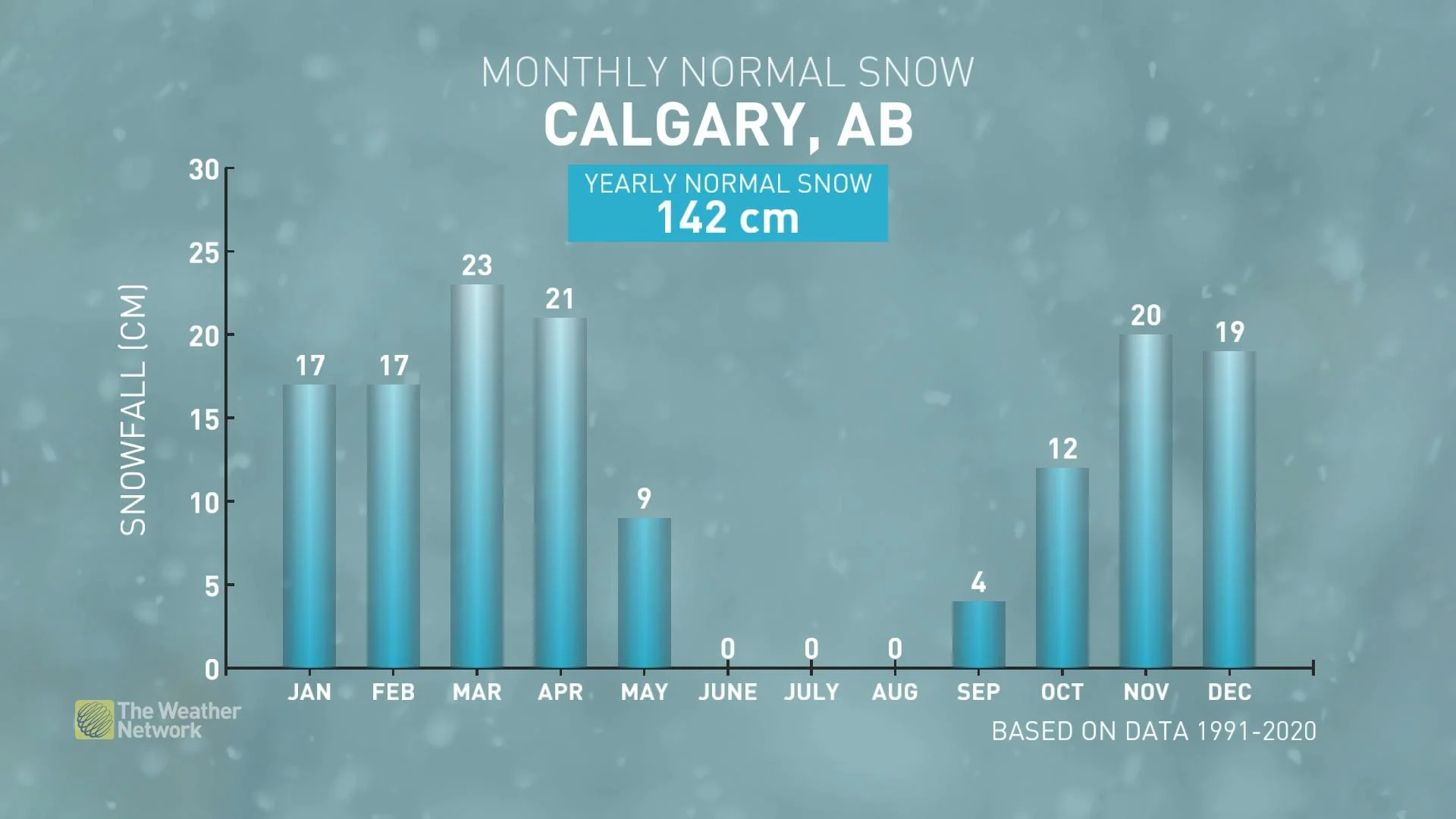
Low-pressure systems pick up in both frequency and intensity as winter’s chill slowly starts to clash with the encroaching warmth of a looming spring. These moist storms run against cold air hanging tight across Canada, providing the setup for hefty snowstorms to continue sweeping the country.
As a result, March and April are historically the snowiest months of the year in Calgary, and folks across the east are still vulnerable to messy winter storms for a while to come.