
Spring 2019: Soaring in west, longer struggle in the east

The details on how this temperamental season will play out for your part of Canada, plus the first look at summer 2019.
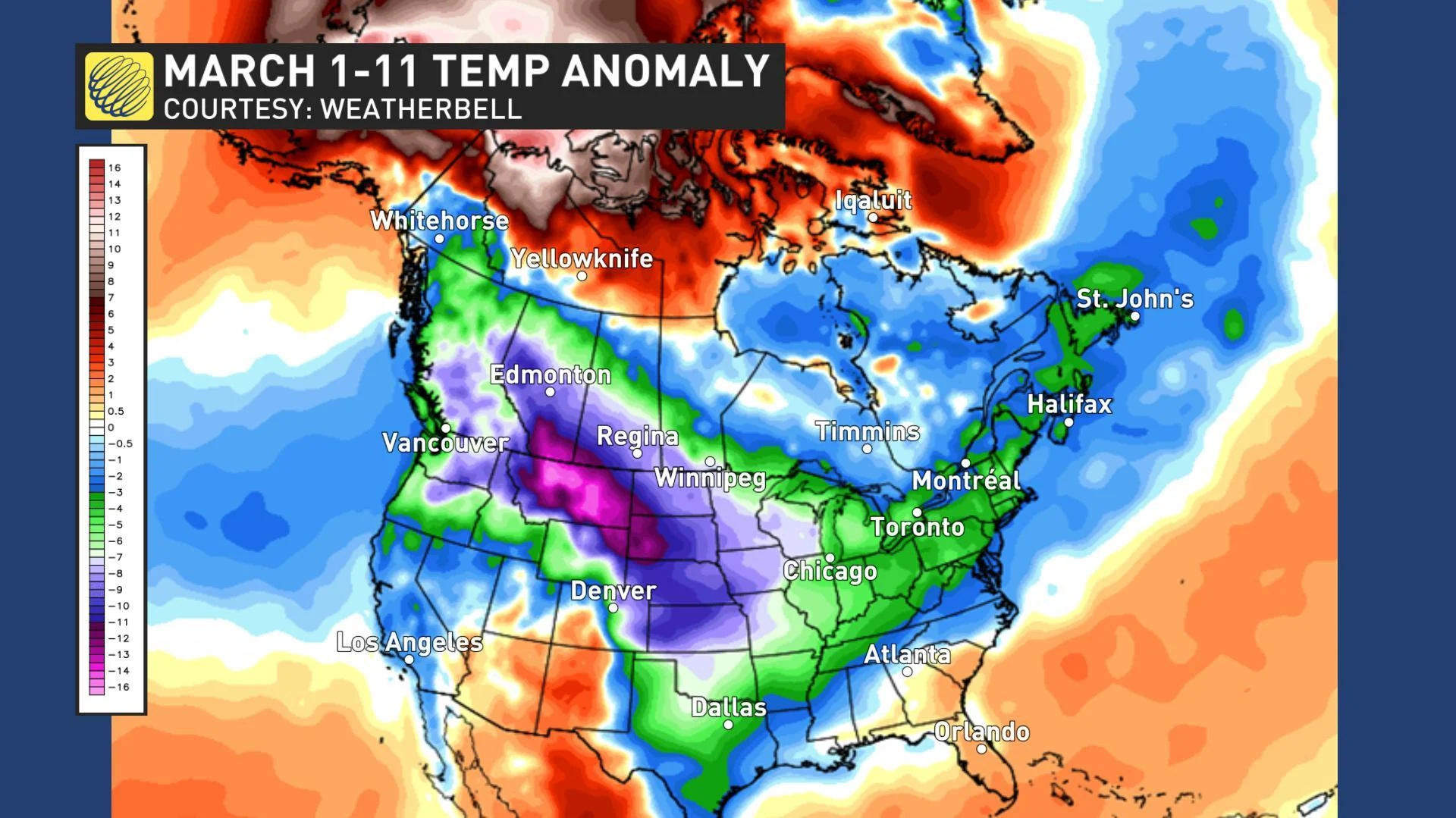
Meteorological spring starts March 1st, but early March featured mid-winter weather from coast to coast. The map below shows the temperature anomalies that we saw during the first 11 days of March with the various shades of blue, green and violet highlighting colder than normal temperatures. The coldest weather relative to normal was found across the west.
Visit our Complete Guide to Spring 2019 for an in depth look at the Spring Forecast, tips to plan for it and much more
However, as we headed into mid-March the persistently frigid pattern broke down across Canada. The map below shows temperature anomalies during the past week, with the various shades of orange and red highlighting above normal temperatures.
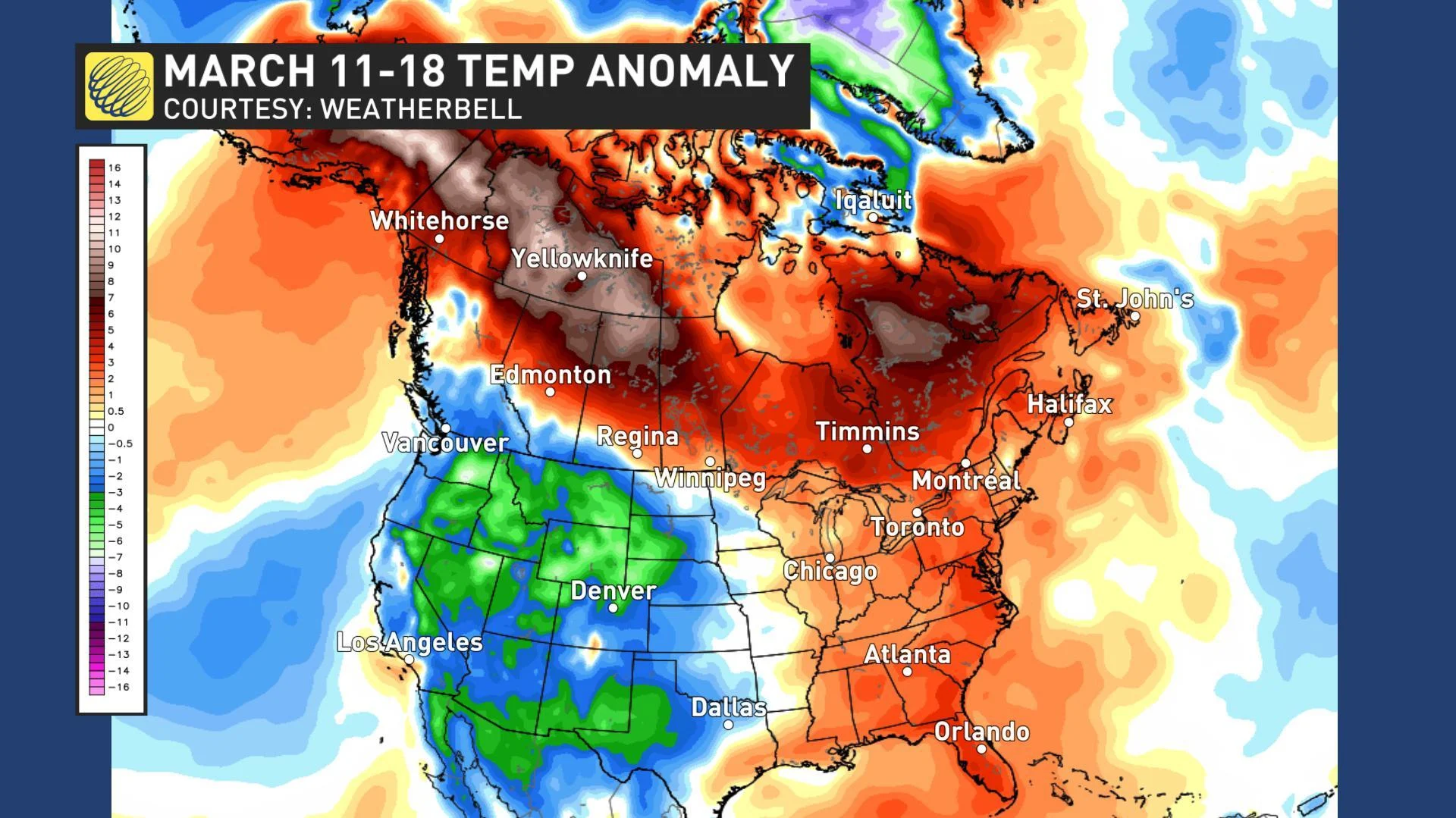
The pattern change has become most dramatic across western Canada where numerous high temperature records have been broken this week. Across southern Alberta, temperatures have gone from being much as 20 degrees colder than seasonal at the beginning of March to nearly 15 degrees warmer than seasonal this week.
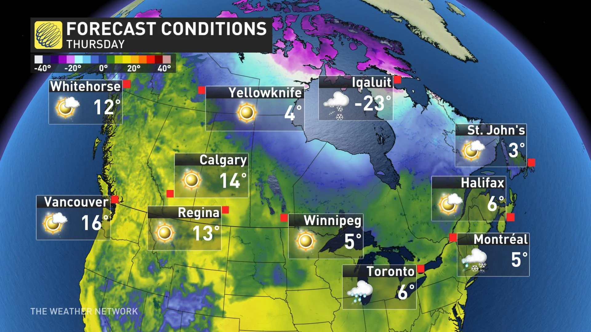
The map below shows our high temperature forecast for Thursday across Canada – the first full day of spring. This highlights the May-like temperatures across the west and near seasonal temperatures across the east, which is quite a contrast to how we started March.
SPRING TEMPERATURE PATTERN
So, where do we go from here? The map below shows our spring temperature forecast.
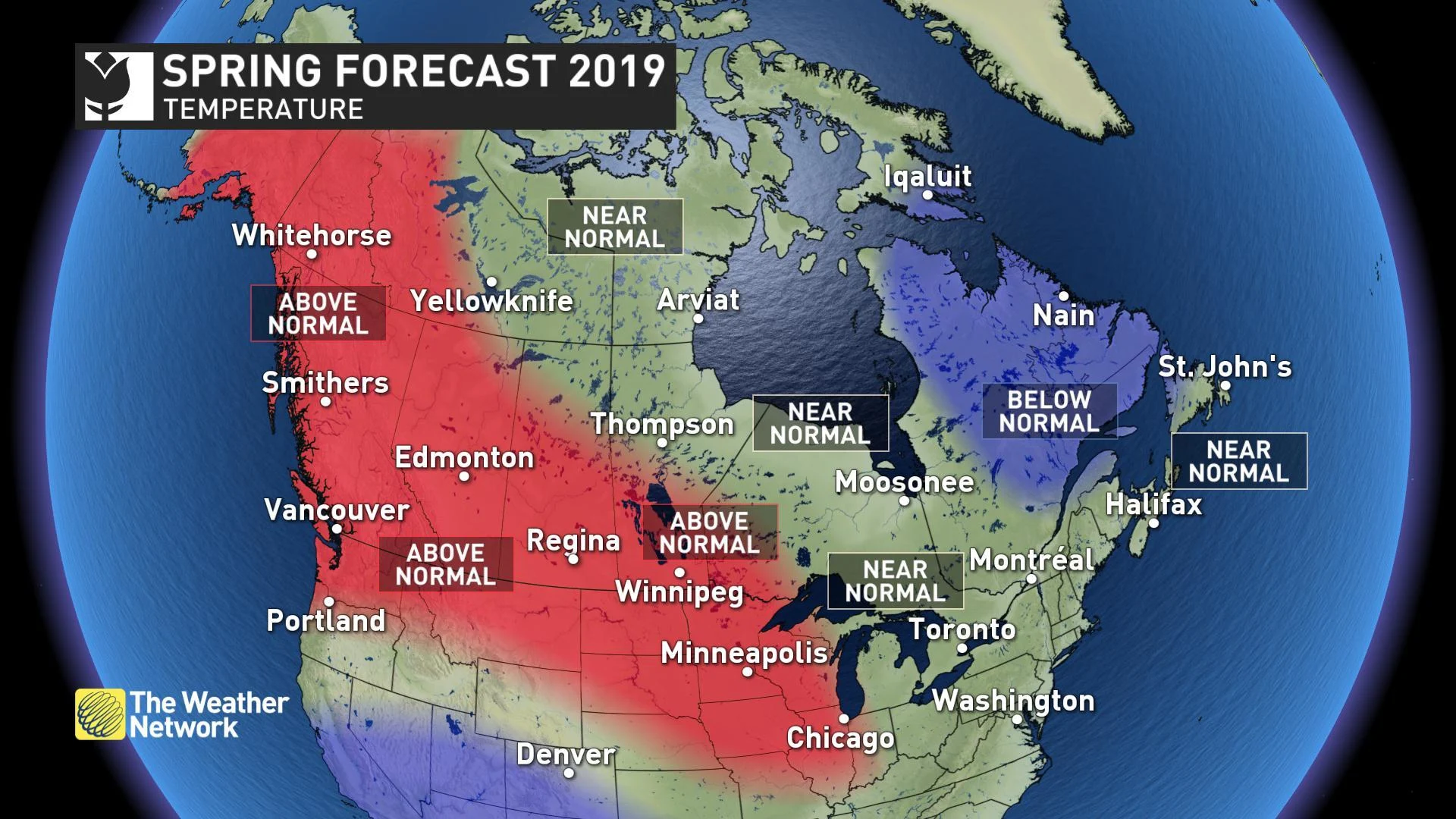
Near normal or above normal temperatures are expected to dominate across most of the country – a welcome contrast to the second half of winter. However, it is important to remember that spring is a tumultuous season, and this year will be not be an exception. Everyone should still expect chilly interruptions as we make the transition from winter to summer.
Across western Canada, including much of the Prairies, above normal temperatures are expected to be more dominant than the periods of colder weather. Spring will struggle longer across eastern Canada, but the final numbers are expected to be near or just slightly colder than seasonal. For most of Ontario and southern Quebec, we expect that the back and forth swings in temperature will come close to offsetting each other, meaning a typical spring for these regions.
SPRING PRECIPITATION PATTERN
We expect near normal precipitation across most of Canada, but above normal precipitation is expected for parts of northern Ontario and Manitoba and from the central coast of B.C. to the Yukon. We are also watching the risk for drier than normal conditions across parts of the southern Prairies.
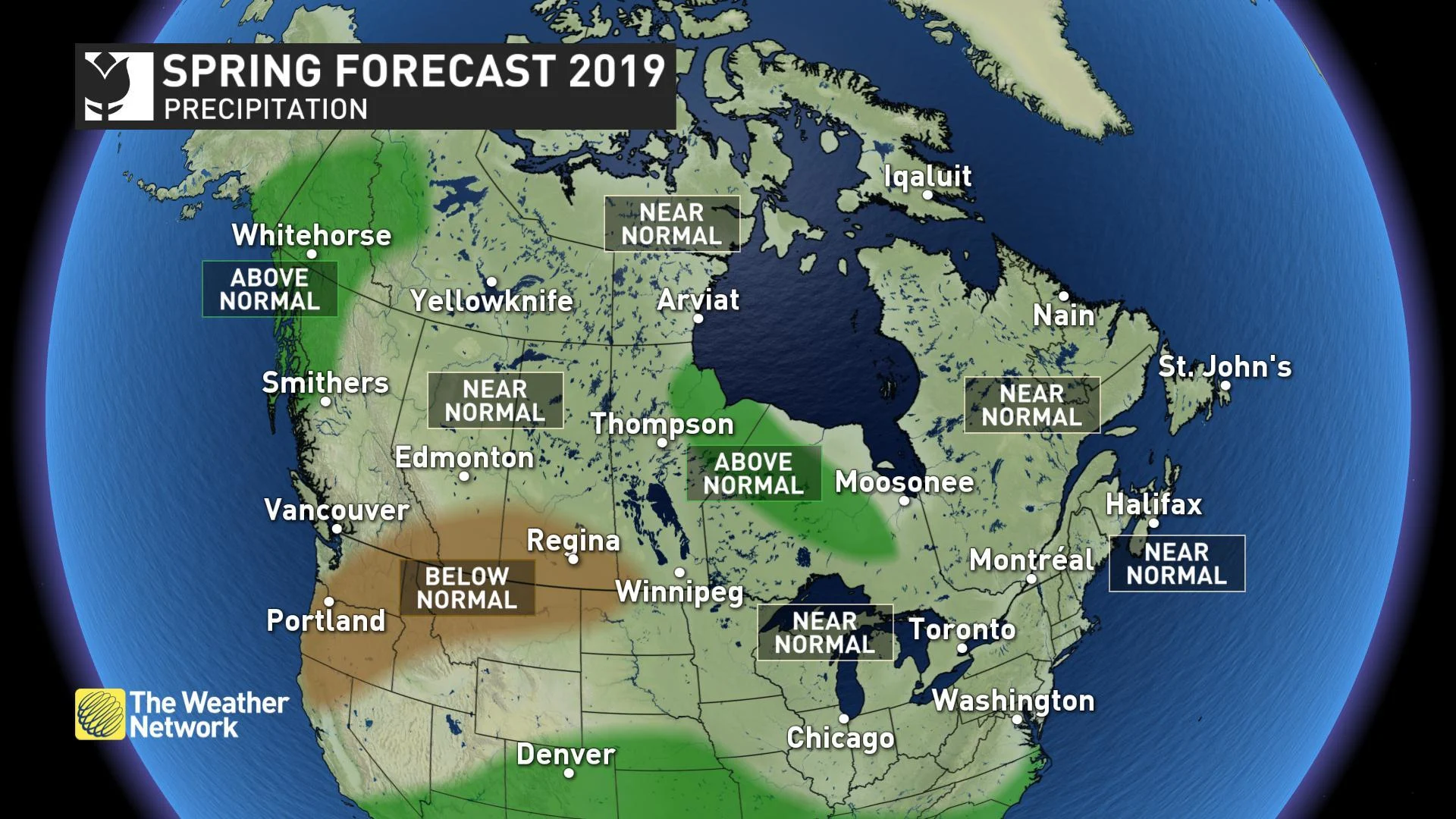
We expect fewer than normal storms across eastern Canada this spring, but some of the storms will tap into subtropical moisture and bring substantial rainfall totals. This will result in seasonal totals that are close to normal.
Spring flooding is also a major concern this spring for many regions of the country, especially where we will have well above normal amounts of snow on the ground.
For more regional details on our forecast for the rest of March, April and May for each region of the country, please read on.
BRITISH COLUMBIA
After a frigid and snowy February and early March, spring has finally arrived. Warmer than normal temperatures are expected to dominate through the season, but it will not be smooth sailing all the way to summer as periods of cooler and unsettled weather will still occur at times. During the periods of warmer weather we still have a heightened threat for flooding from rapid snow melt in the alpine regions.
FORECAST FOCUS: 'EXTREME ANOMALIES' A SPRING THEME IN B.C.
THE PRAIRIES
A dramatic pattern change has occurred across this region and warmer than normal temperatures are expected to dominate through spring. Unfortunately, this continues to bring the threat for spring flooding across the regions where there is deeper than normal snow cover (especially near and north of the Yellowhead Highway).
However, the Prairies are notorious for their wild swings in weather, and this spring will continue to solidify that reputation. Despite warmer than normal temperatures for spring as a whole, we will still have to watch the threat for shots of colder/wintry weather through the season.
WATCH BELOW: ABRUPT ARRIVAL FOR PRAIRIE SPRING
ONTARIO AND QUEBEC
March has brought a transition from January-like weather to a pattern more typical of March. However, the road to consistent spring weather does contain more pot holes than initially expected as the rest of March will still bring a couple shots of colder weather.
April and May will bring back and forth swings in temperature that are typical of the season. That means that we will see a more typical spring this year, in contrast to the consistent cold pattern that we saw last year. During the periods of warmer weather we will continue to have a heightened threat for spring flooding, especially across northern Ontario, cottage country and the Ottawa Valley where the snow depth is well above normal.
ONTARIO SPRING FORECAST 2019: TEMPERATURES, AND FLOODING CONCERNS, ON THE RISE
ATLANTIC CANADA
The arrival of consistent spring warmth will be delayed across this region, but we expect that April and May will bring alternating periods of warmer and colder than normal temperatures which should come close to offsetting each other across most of the region. However, across northern areas, temperatures are expected to tip to the cold side of normal, especially during the first half of spring.
We expect fewer storms than normal, but near normal precipitation totals as a few of the storms will tap into subtropical moisture and bring heavy rainfall. This will also heighten the threat for flooding, especially across northern regions where we have deeper than normal snow cover.
ATLANTIC SPRING FORECAST 2019: 'A BIT OF A BUMPY RIDE'
NORTHERN CANADA
Above normal temperatures are expected across the Yukon and the western half of the Northwest Territories. Near normal temperatures are expected across the rest of the region, including the eastern half of the Northwest Territories and most Nunavut, but colder than normal temperatures are expected around Iqaluit. Above normal precipitation is expected across the Yukon and into adjacent parts of the Northwest Territories with near normal precipitation elsewhere.
SNEAK PEEK TO SUMMER
As we progress through the spring season, one of the keys to the summer forecast that we will be watching will be the progression of the weak El Nino event that was officially declared back in February. However, the impact of El Nino on the global weather pattern is typically weaker during the summer than it is during the winter and there are numerous other factors that that we will consider as we develop our final summer forecast.
At this point it looks like warmer than normal temperatures will dominate the summer across B.C. and parts of Atlantic Canada. In between we will have a large region in which we expect near normal temperatures and embedded within that region we will have the potential for cooler than normal weather.
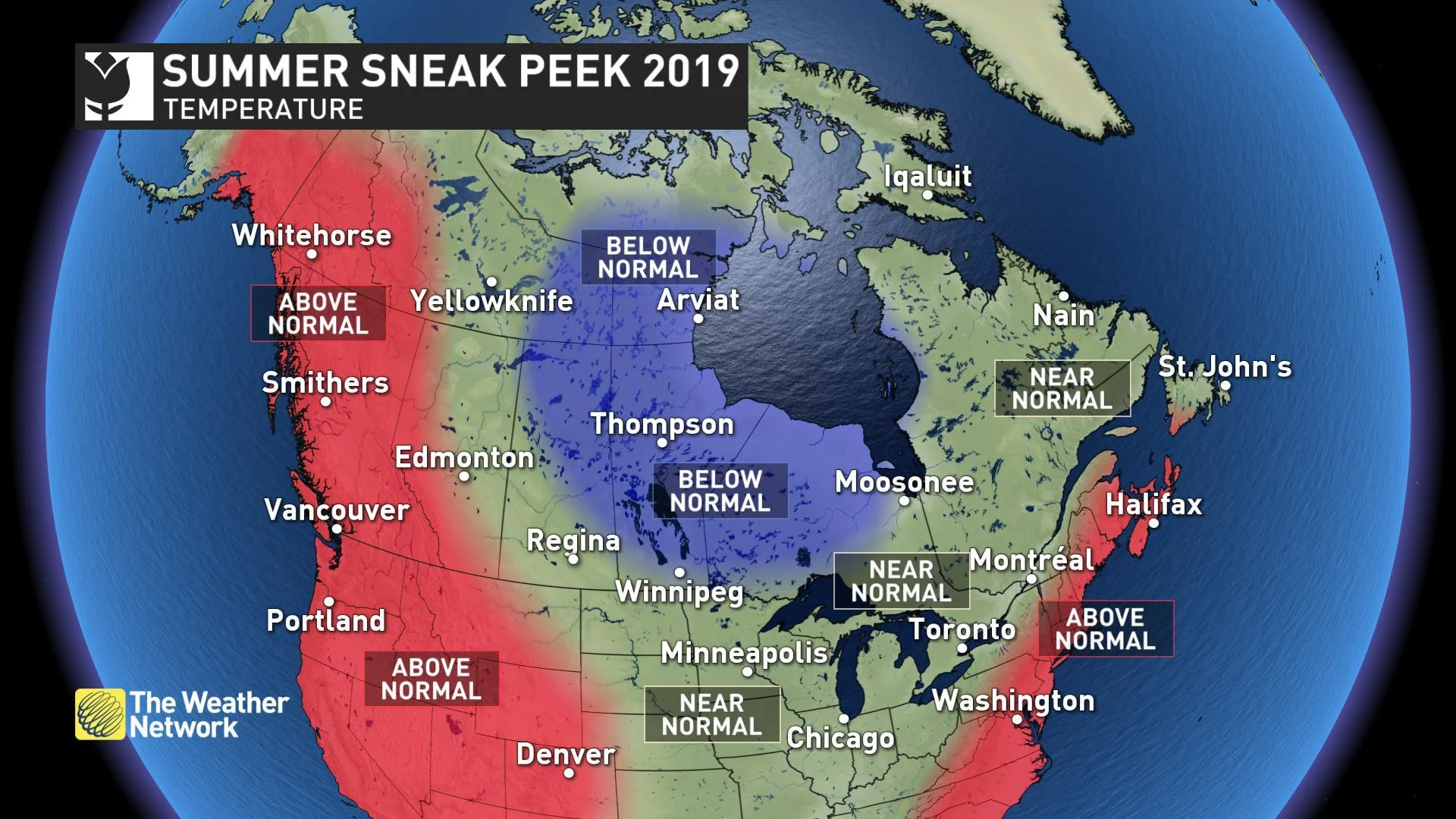
However, we are unsure as to whether this cooler weather will be centered across the Prairies or further east towards the Great Lakes. If El Nino remains weak, then the cooler weather will likely be further west with another warm to hot summer for southern Ontario and southern Quebec. Stronger El Nino conditions could result in the cooler weather shifting further to the east towards the Great Lakes.
Regardless we expect a very warm summer across B.C. and we are concerned about increasingly dry conditions and an increasing wild fire threat in the west. Meanwhile, we expect a more active pattern from the Great Lakes to the Maritimes.


