
2X Faster: More flooding, rapid sea level rise in Canada
The Weather Network is rolling out a three-part series that will analyze how this report will impact each region of the country. This is the second installment of our 2X Faster series and will address how Canada’s lakes and oceans are impacted by global climate change.
Canada’s lakes and oceans are important features of the nation’s unique landscape, have significant impacts on regional weather, and shape both the national and local economy.
The biggest Canadian industries including agriculture, fisheries, and tourism, all rely on the health and optimal functioning of lakes and oceans. The warming climate has already caused damaging changes to Canadian lakes and oceans, and a new study from the Canadian government warns that climate change will amplify the damages as water levels in lakes fluctuate, ocean waves and storm surges increase in size, and flooding becomes more frequent.
This article will address how Canadian lakes and oceans will change throughout the 21st century based on the findings of Canada's Changing Climate Report (CCCR).
INCREASED FLOODING, GREAT LAKES BASIN RAPIDLY CHANGING
Global bodies of water across the world have varying responses to warming temperatures in the atmosphere, yet this report states that some of the most dangerous changes, such as sea level rise, are occurring faster in Canada. The nation’s population is significantly distributed along bodies of water – over 34 million live within the Great Lakes Basin, and some of the most populated cities in Canada, such as Vancouver, Victoria, and Halifax are located near oceanic coastlines.
Urban flooding is a growing concern as the number of impacted properties, such as homes at risk of basement flooding, are on the rise. The rising annual temperatures increase the atmosphere’s ability to hold moisture, which will cause a shift towards earlier floods associated with spring snowmelt, ice jams, and rain-on-snow events. The flow of water in streams and rivers are projected to increase each year in northern areas while declining in southern regions.
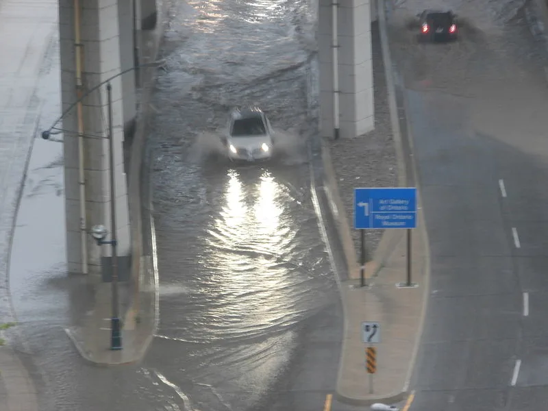
Flash floods in Toronto on July 8, 2013. Toronto, Ontario, Canada. Credit: Wikimedia Commons
The differences in regional flows are linked to varying precipitation trends – the average annual precipitation in Northwest Territories could range from 300 to 400+ millimetres whereas North Vancouver, B.C. could see over 2,000 mm. Northern basins, such as the Mackenzie River, are projected to see an increase in annual flows whereas southern continental regions, such as Quebec, will see a decrease.
Meanwhile, both the west coast and the east coast are projected to see more flooding due to increased rainfall, increased rain-on-snow events in coastal watersheds, and more rapid snowmelt events in interior watersheds.
River flooding is a natural occurrence when seasons transition to warmer periods of the year when snowmelt and spring showers raise water levels of streams and rivers. An unusual occurrence, however, is the timing of the flooding becoming earlier and heavier, says the report.
The timing of flooding events is significantly influenced by climate change and the warming temperatures will cause an earlier onset of spring freshet and more rainfall generated flows.
The report shows that the timing of ice-influenced peak water levels and ice breakup has started earlier in the season since the late 1960s. Some areas of Canada, such as the Saint John River in New Brunswick, have experienced more frequent mid-winter ice jams and higher water levels in April, both of which increase the risk of major flooding. This region is currently recovering from devastating flooding where water levels have surpassed those in 2018 and required assistance from hundreds of Canadian military troops.
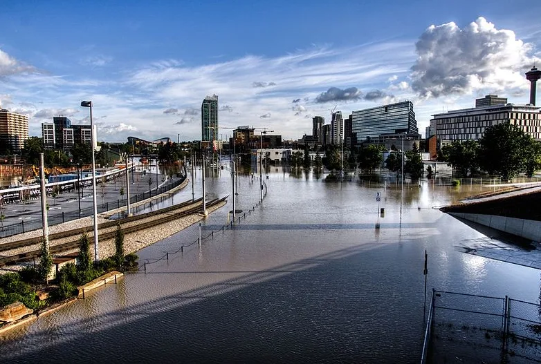
East Village Calgary flood in 2013. Credit: Wikimedia Commons
Scientists are studying how climate change has impacted extreme weather events, and a study of the 2013 southern Alberta flood determined that human-induced global warming increased the likelihood of extreme precipitation that was recorded in this event. While a number of other meteorological and environmental factors were the cause of this event, this damaging and costly weather event demonstrates how natural behaviours of the environment can potentially be altered by the warming atmosphere.
The Great Lakes Basin, which is home to more than 3 million Canadians, is projected to see an increase of changes due to the warming climate include shoreline erosion, property flooding, economic losses, damage to aquatic systems, and increased risks to human health. Increasing evaporation rates and fluctuating rates of snowmelt are changing the water levels of these bodies of water, and many studies show that the Great Lakes will lower by approximately 0.2 metres by mid-century compared to the average water levels observed from 1971 to 2000.
OCEANS ARE RISING AS WAVES BECOME BIGGER
Sea level rise on both the east and west coasts of Canada is threatening to flood communities that are home to millions. Newfoundland, the Beaufort Sea coast of the Northwest Territories and Yukon are seeing sea level rise faster than the global average, and Halifax experienced sea level rise at a rate of about 3.3 mm per year during the 20th century.
By 2100 global mean sea level is projected to rise from 28 to 98 centimetres because of glacier and ice sheet melt, and thermal expansion, which refers to the expanding motion of water as it warms and occupies more volume.
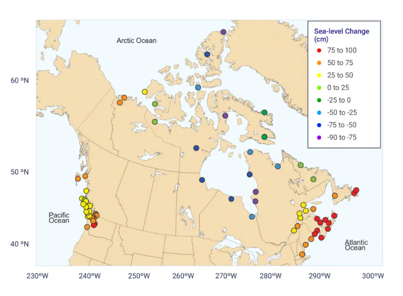
Source: James et al. (2014, 2015); Lemmen et al (2016).
The graph above shows the projected relative sea-level changes shown at 2100 for if carbon dioxide emissions continue on a business-as-usual pathway at 69 coastal locations in Canada and the northern United States. The projections show a sea level rise of up to 93 cm and are relative to the average conditions in the 1986–2005 period. For comparison, the projected median global sea-level change in 2100 for this same emission scenario is 74 cm.
The frequency and magnitude of extreme high-water levels are projected to increase, meaning that coastal communities will see increased flooding that could damage infrastructure and ecosystems. In addition to the climbing sea levels, surface wave heights and wave activity are also increasing.
Winds are a powerful feature of marine storms, and the increasingly large waves that form directly from the wind blowing over the surface of the ocean can have devastating impacts on both the offshore economy and coastline communities. Extreme high water-level events and storm surges are also expected to become large and more frequent in along the Arctic and Atlantic coastlines, due to declining sea ice cover.
SEE IT: STORM SURGE ON THE WEST COAST OF NEWFOUNDLAND
Several mechanisms of the oceans serve as clear indicators that global warming has a direct impact on the part of the environment. Between 1971 and 2010 the oceans have absorbed more than 90 per cent of the increase in heat that the climate has gained, and between 1750 to 2011 the oceans have absorbed more than 25 per cent of all carbon emissions released by humans. Oceans play an important role in storing carbon away from the atmosphere, but under climate change, the Labrador Sea is projected to store less carbon at deep levels due to surface warming as it has warned 0.13°C per decade since 1950.
Global sea level will continue to rise for centuries beyond 2100, with rates dependent on future greenhouse gas emissions and the potential melting of the Greenland and West Antarctic ice sheets.


