
Brief, but intense Arctic air brings coldest weather of the season to Ontario

This winter across southern Ontario can be described as an "on again, off again" type of pattern, with the start of this week signaling that the frosty season is certainly "on." The region woke up to the coldest temperatures of the season early Tuesday - and for some, the coldest temperatures in almost three years - as bitterly cold Arctic air flooded in and overnight lows plunged into the -20s and -30s. Widespread extreme cold weather alerts were issued across the province, warning residents to dress warmly and check on those more vulnerable to the conditions. By Wednesday however, temperatures soar above freezing once again, so it'll be a bitter, but brief blast of cold air to get through Tuesday. More on what's left of January and if any consistent cold locks in, below.
DON'T MISS: Flip the switch: Western Canada warms up as polar vortex shifts east
TUESDAY: COLDEST AIR OF THE SEASON SPANS THE REGION, POTENT SNOW SQUALLS EASE
A rather strong cold front that ushered in frigid Arctic air to Ontario also set off potent snow squalls to start the week. Travel was certainly hampered Monday in many locales near Lake Huron and Georgian Bay, with as much as 15-30+ cm of snow forecast in the hardest hit places through Tuesday. As a result of the treacherous conditions, some roadways were closed and at least one accident was reported on the southbound lane of Highway 400.
All snow squall warnings were dropped early Tuesday, but local whiteout conditions may persist on some major routes and highways before gradually improving throughout the day.
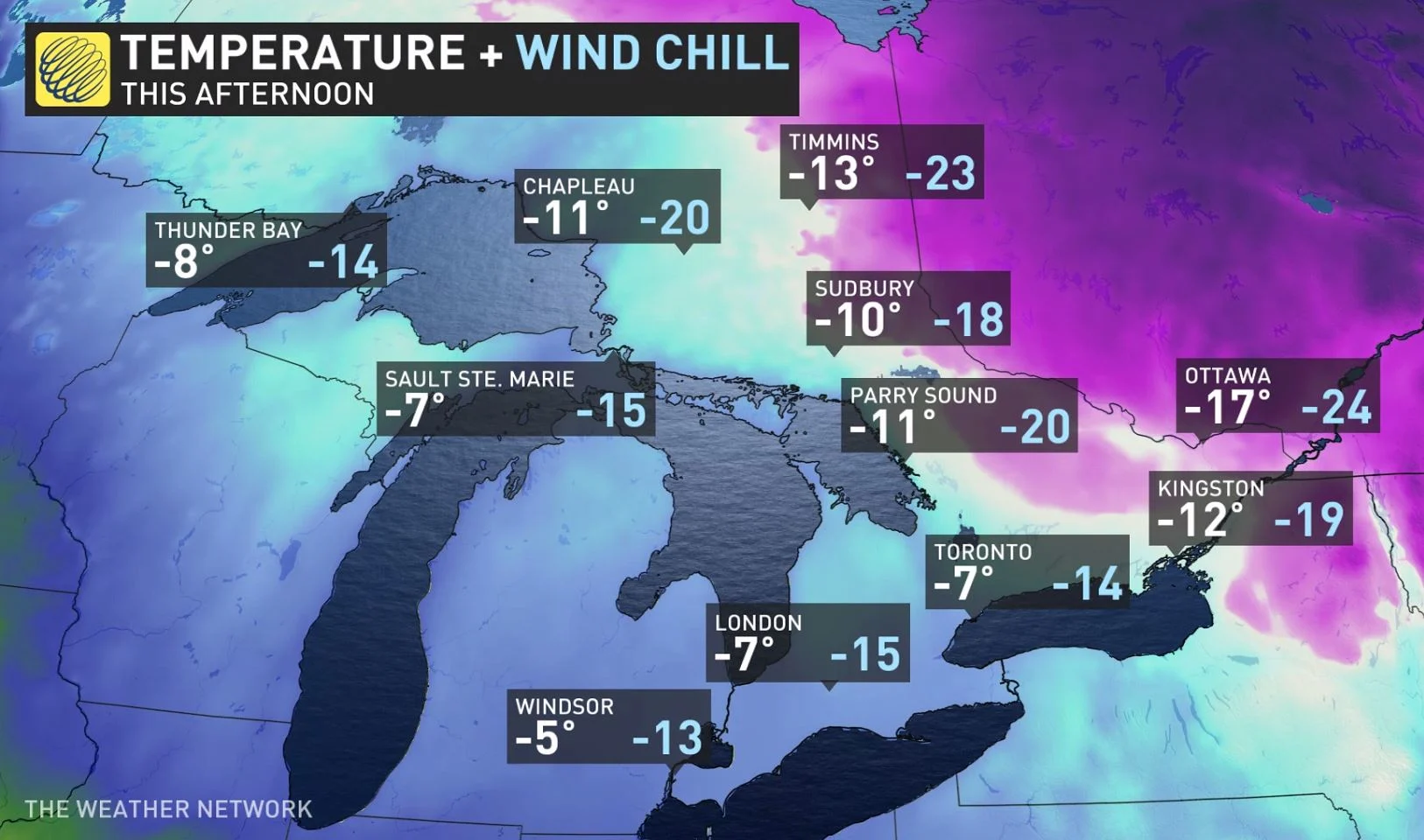
Extreme cold warnings were widespread across the province early Tuesday however, as bitterly cold arctic air combined with light winds brought some of the coldest air of the season so far.
WATCH BELOW: WHAT YOU NEED TO KNOW ABOUT TORONTO'S COLD WEATHER ALERT
DON'T MISS: This simple hack can help save your hands this winter
Temperatures dipped into the -20s through the overnight hours on Monday, feeling closer to the -30s and -40s with the frigid wind chill.
This may feel especially chilly since the last time the city of Toronto reached a low of -21°C was back on January 31, 2019. Nearly three years ago. Also, on the heels of a mild December, so far this January, there have been five days above the freezing mark for Toronto's daytime highs.
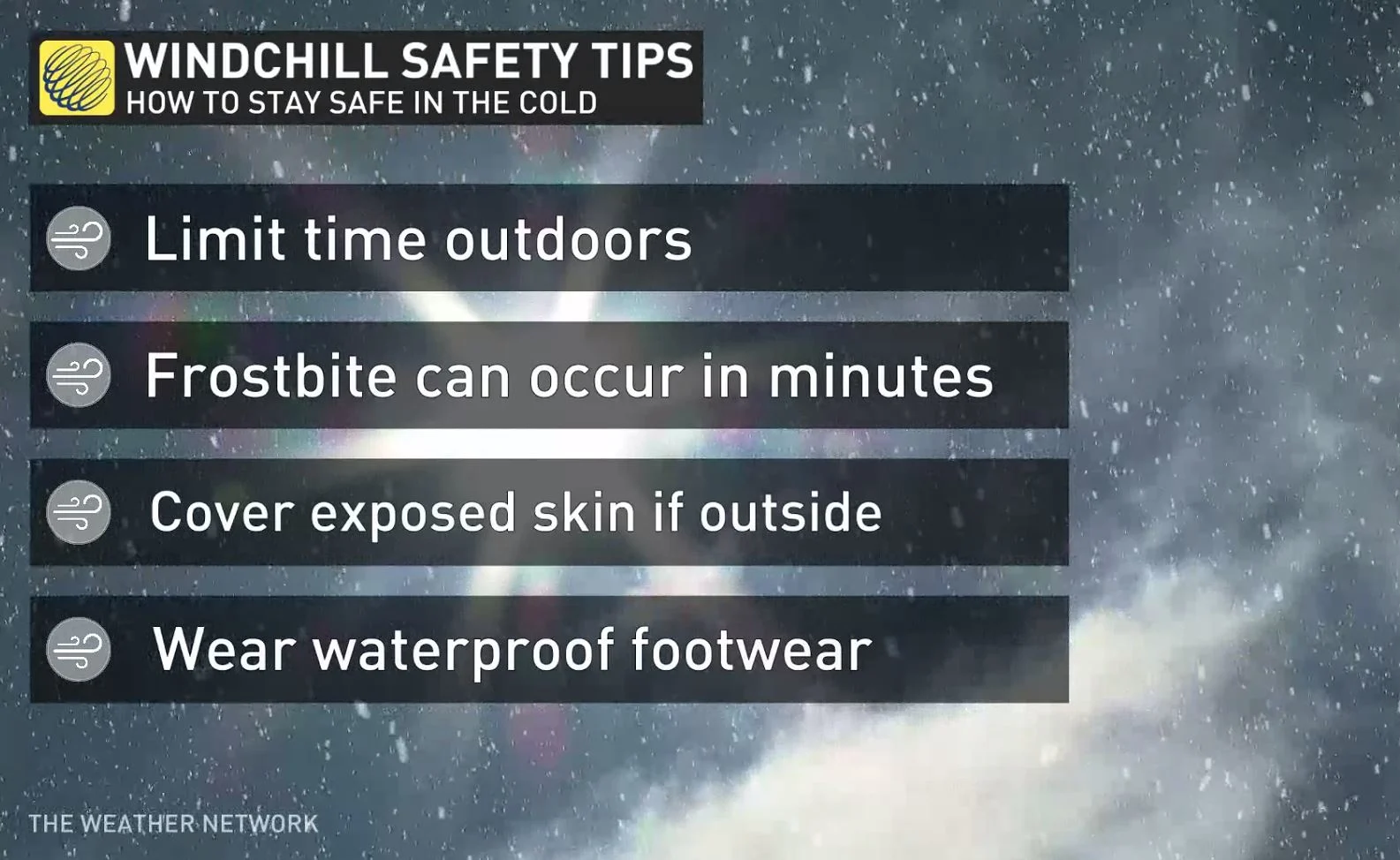
"Extreme cold puts everyone at risk," says Environment and Climate Change Canada in the extreme cold warning. "Risks are greater for young children, older adults, people with chronic illnesses, people working or exercising outdoors, and those without proper shelter."
Wind chills will moderate Tuesday morning after sunrise.
High temperatures will only be near the -20s on Tuesday for Ottawa though, with overnight lows reaching the -30s outside of urban areas.
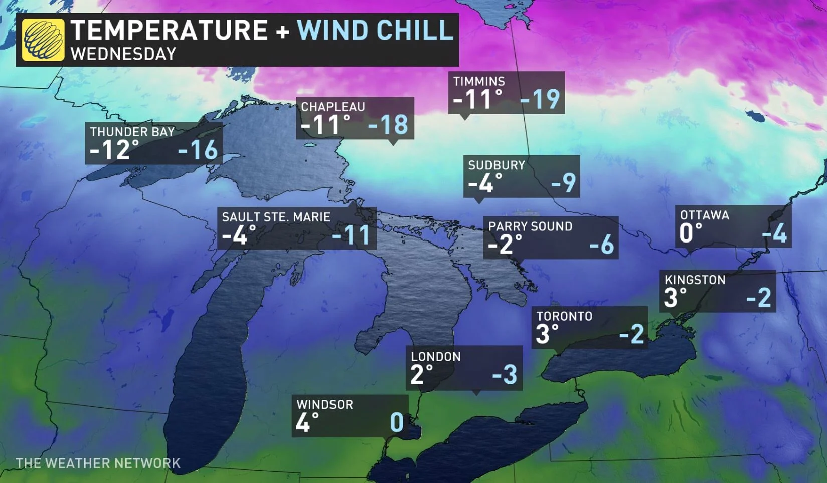
"This will be a quick shot of frigid weather however, as temperatures will quickly rebound back to near or above seasonal — above freezing for southern Ontario — Wednesday and Thursday," says Dr. Doug Gillham, a meteorologist at The Weather Network.
That's as winds shift directions out of the southwest, really helping to warm things up and break apart the snow squall activity.
Beyond, no major storms are in sight for the region, though forecasters are keeping an eye on a system that is expected to track well south of the border this weekend. The forecast track at this point is much too far south to have a direct impact on the region, but we could have a cold easterly flow off Lake Ontario -- bringing the potential for a band of lake-effect snow near the west end of the lake.
A more wintry pattern is expected for next week and into the following week as well, with temperatures near seasonal or on the cold side of seasonal much of the time, and the potential for the pattern to become more active or at least more typical of the season at this point.
Be sure to check back for the latest weather conditions in Ontario.