Flood fears remain high on the East Coast after 200+ mm of rain recorded

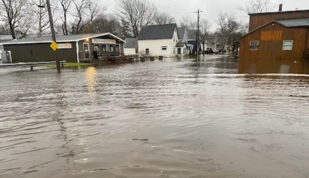
Many areas across Nova Scotia and southwestern Newfoundland are facing some significant damage, as an atmospheric river takes aim at the East Coast this week. Excessive and record setting rainfall washed out and closed roads, and intense winds with gusts upwards of 100 km/h knocked out power to thousands through early Wednesday. While some areas have seen the worst of the wind and rain subside, there is still some left to come for eastern Nova Scotia and coastal sections of Newfoundland on Wednesday. Rainfall warnings remain in place for some regions, with these additional totals heightening further flood concerns. More on what's left to come, below.
WEDNESDAY: FLOOD FEARS MOUNT AS ADDITIONAL RAIN HITS EASTERN NOVA SCOTIA, SOUTHWESTERN NEWFOUNDLAND
Much of the Maritimes are seeing a tremendous amount of Gulf and subtropical moisture this week, with numerous lows trekking across. Tuesday saw the storm knock out power to thousands across Nova Scotia, the cancellation of crossings and flooding closing several roadways including a section of Highway 245 near Antigonish.
On Tuesday night, Nova Scotia's emergency management office declared a state of emergency for Inverness and Victoria counties after heavy rainfall washed out roads and left streets looking more like rivers and ponds.
MUST SEE: Flooding prompts state of emergency, road closures across eastern N.S.
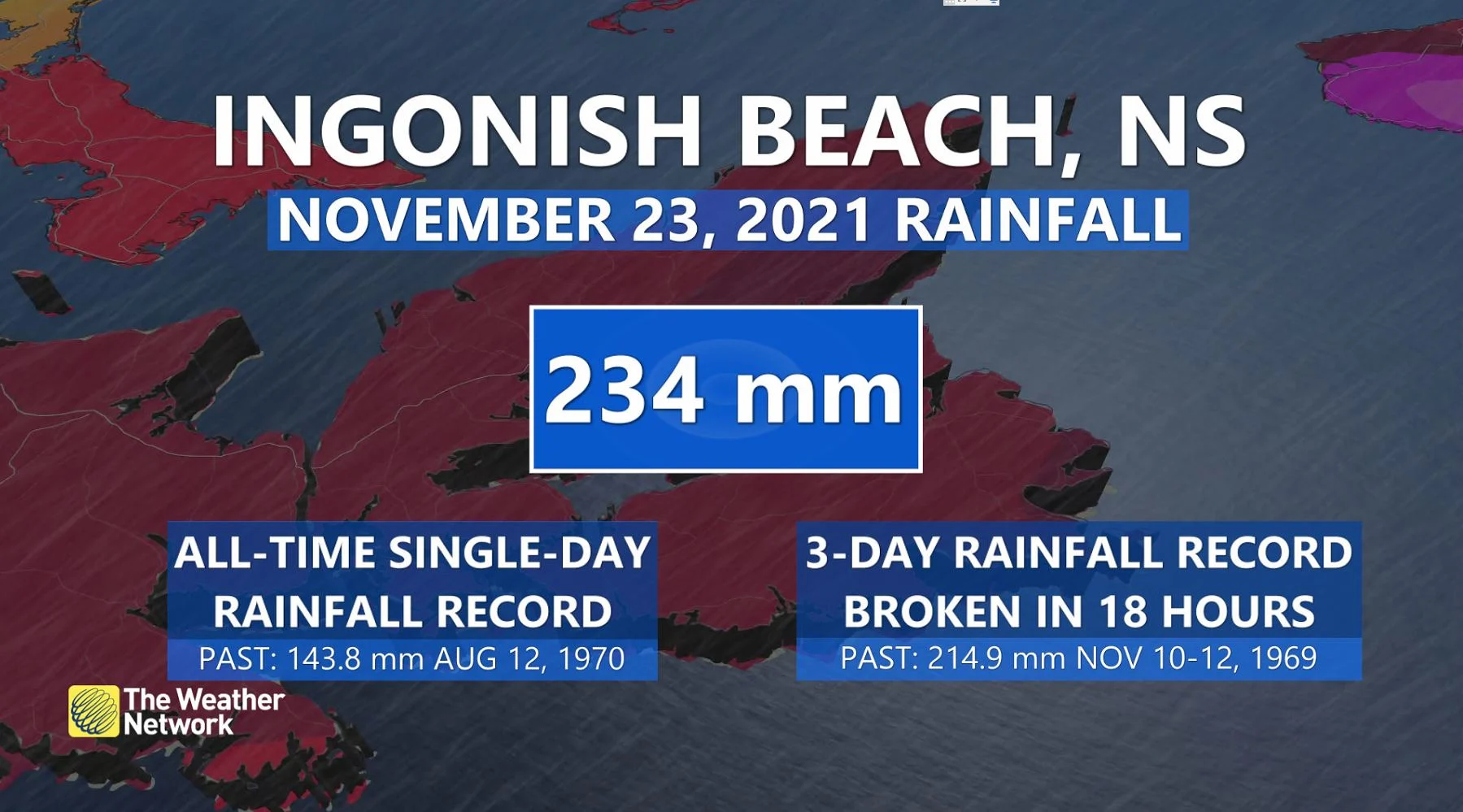
In addition to those impacts, Ingonish Beach, N.S., set an all-time single-day rainfall record with 234 mm recorded.
The potent storm washed away areas of the Trans-Canada Highway in southwestern Newfoundland, with multiple road washouts reported in the Codroy Valley area. By Wednesday morning, Port aux Basques had received nearly 130 mm of rain.
CLOSURES: The Department of Transportation is reporting multiple washed out roads
On Wednesday, a strong blocking high across the east will force this system to retrograde, essentially moving backwards from east to west, continuing to impact much of Atlantic Canada with ongoing rain.
Localized flooding will remain a concern, as an additional 15-30 mm of rain continues for Cape Breton, N.S., before gradually easing throughout the day. Meanwhile, southwestern Newfoundland will continue to be battered by heavy rain into the afternoon hours, with 50-100 mm forecast in the hardest hit areas there.
"Heavy downpours are likely to cause flash floods and water pooling on roads," Environment and Climate Change Canada (ECCC) warns. "Avoid driving through water on roads. Even shallow, fast-moving water across a road can sweep a vehicle or a person away."

Flooding rains and powerful winds wreak havoc across Sydney, N.S. (Nathan Coleman)
As well, the Maritimes will see daytime highs drop drastically in the wake of the frontal boundary passing through.
As a result, there is the risk of rain transitioning over to a wintry mix --brief freezing rain, ice pellets or wet snow -- as temperatures remain below freezing. Slick conditions are quite possible for areas including Halifax, N.S., and into southern New Brunswick.
RELATED: West vs East: Canada sandwiched between atmospheric rivers
LOOK AHEAD: WINDY, UNSETTLED WEATHER LINGERS
Beyond, windy and unsettled weather will continue through Saturday, but the heavy rain will be over before on Thursday. Low pressure over the Atlantic, south of the region, will continue to meander through the end of the week and then merge with another system approaching from the west into the weekend.
A strong blocking pattern over the North Atlantic is responsible for this extended period of unsettled weather as it is preventing the system from escaping out to sea. Temperatures will be very mild, including a couple days of double digits for Newfoundland, in the southerly flow ahead of the system.
Meanwhile, forecasters are watching the potential for heavy snow for northwestern New Brunswick late Friday through Saturday.
WATCH BELOW: STRONG WINDS SEND TREE CRASHING DOWN ON CAR IN NOVA SCOTIA
Be sure to check back for the latest updates across Atlantic Canada.