More trouble lies ahead for flood-stricken B.C. with new rain barrage

Adding insult to injury in B.C. will be more rounds of soaking rains in the next several days, courtesy of not one, but two atmospheric rivers. Potentially, they could dump an additional 100+mm of rainfall to some areas that have been hit hard by the recent flooding.
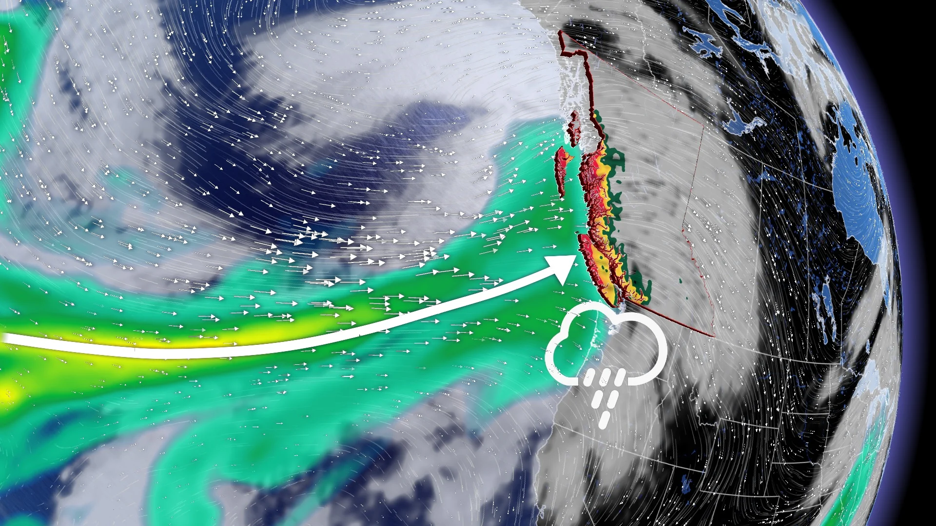
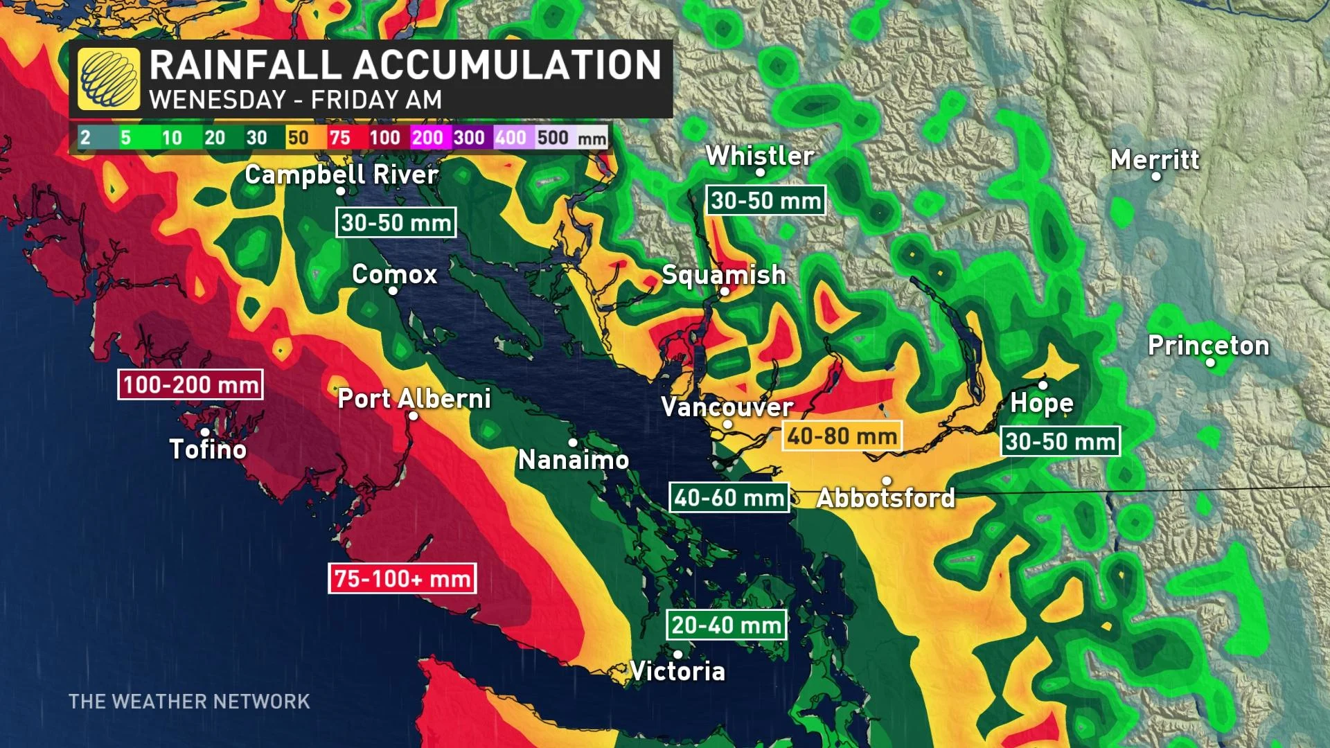
November has not been a kind month to B.C. With the province still dealing with recovery from last week's damaging atmospheric river, there are now two more on the way. The first will slither onto the North and Central coasts, then channelling its way onto the southern end by Wednesday night. This isn't good news for the flood-stricken areas, as some regions could see 100-200 mm of rain by Friday, likely delaying the recovery process. On top of that, freezing levels will increase Thursday, allowing for rain to hit the mountain passes, also could bring more flooding. For a closer look at timing and impacts, see below.
WEDNESDAY-FRIDAY: FIRST OF TWO ATMOSPHERIC RIVERS PUSHES IN
After last week's Category 4 atmospheric river, the saving grace with the inbound event is that for areas in the south near Abbotsford, Hope, and the impacted communities in the south, the rain will not be as heavy. But, as we have seen with Highway 3 being closed again after very light rain, the ground is already saturated and unstable. As a result, it does not take a lot to cause more damage.
The next atmospheric river is due to infiltrate North and Central coasts through Wednesday and into Vancouver Island and the Lower Mainland by Wednesday night. This storm will be shorter lived and less intense than the previous destructive event.
Rainfall amounts will be heaviest in the North and Central coasts, as well as Vancouver Island. These regions have the potential to see 100+ mm of rainfall through Friday. Western portions of the latter could see up to 200 mm of rain. Meanwhile, the Lower Mainland will be considerably less, with a possibility of 40-80 mm by the week's end. Still, the rainfall will likely worsen the flood-hit areas and delay recovery efforts.
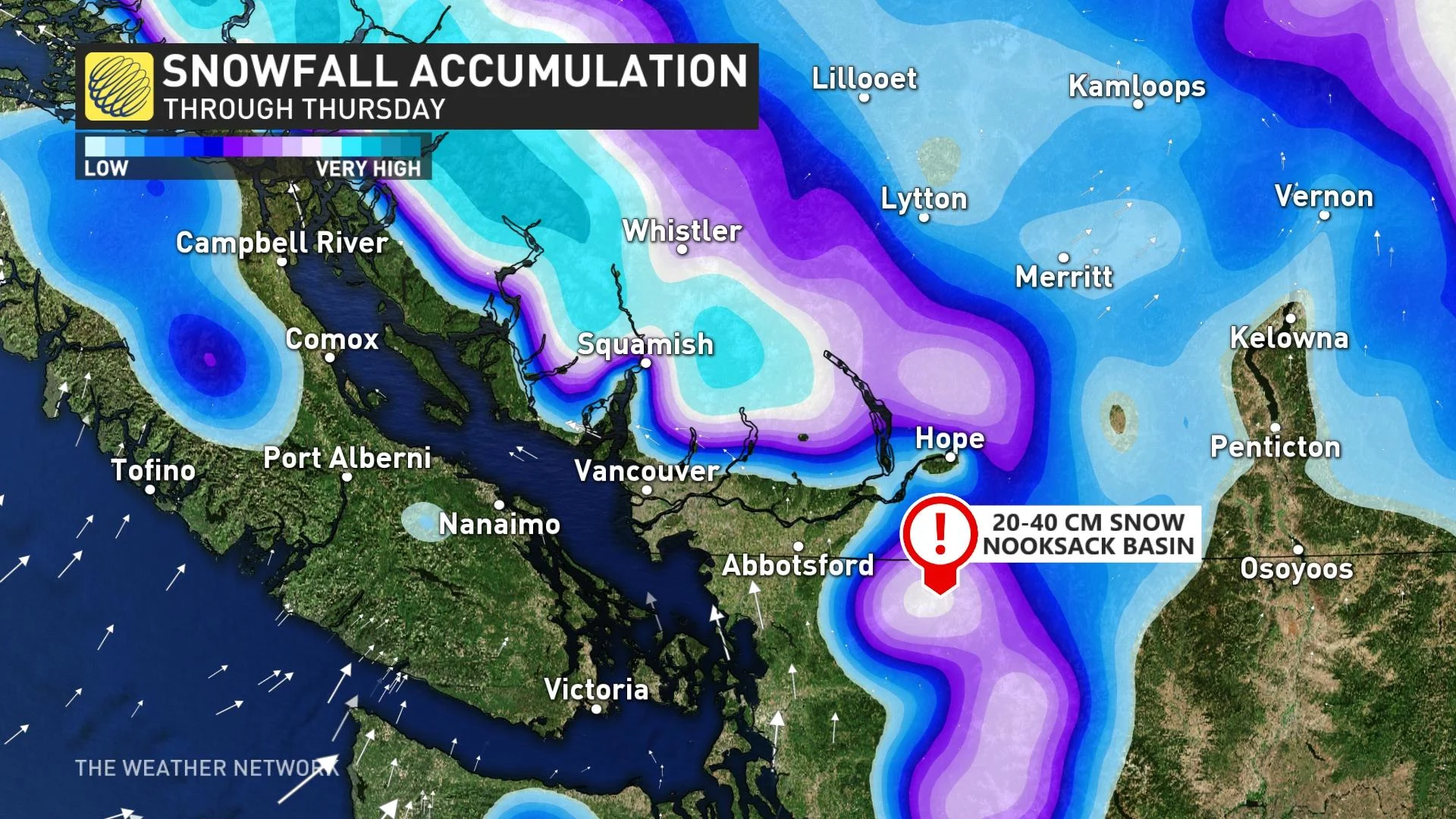
Additionally, piling on top of the stormy conditions, freezing levels will rise above mountain tops on Thursday. This may worsen recent flooding and impact vulnerable landscapes and infrastructure.
Rainfall and wind warnings, as well as special weather statements are in place for the coastal sections and Lower Mainland.
LOOK AHEAD: SECOND ATMOSPHERIC RIVER INBOUND FOR THE WEEKEND, POTENTIAL FOR MORE WET WEATHER
Beyond the first event, the next system is set to move in Saturday evening and continue through Sunday, but the current forecast is for the heaviest rain to be situated over central B.C. and western Vancouver island once again.
That won't be the end of it, either, as another system is expected early next week. Seven-day rainfall totals of 75-125 mm is anticipated for much of the Lower Mainland, with 125-250+ mm for alpine regions and the west coast of Vancouver Island.
Mild temperatures are forecast late week and on the weekend for the South Coast.
CANADA GETTING ITS OWN ATMOSPHERIC RIVER RATING SCALE
Check back as we continue to monitor this week's rainy systems.


