
Pattern change will soon erase the extreme heat in Atlantic Canada

A forthcoming significant pattern change will bring an end to this week's record-breaking heat in Atlantic Canada, giving the region some relief with well-below seasonal temperatures by Thursday and beyond. While there could be some lingering unsettled weather in Nova Scotia early Wednesday morning, conditions will improve through the day as the heat will loosen its grip on the region. Temperatures will be warm, but will be several degrees cooler than earlier in the week. By Thursday, an even more noticeable plummet in temperatures is expected, thanks to the influence of a cold upper trough -- accompanied by some showers for the Maritimes, too. More on the forthcoming cooldown, below.
Visit our Complete Guide to Summer 2021 for an in-depth look at the Summer Forecast, tips to plan for it and much more!
WEDNESDAY: WARMTH BEGINS TO SUBSIDE, IMPROVING CONDITIONS
The heat warnings are expected to drop overnight Tuesday as temperatures drop and the warmth relaxes somewhat Wednesday. It won't be a major dip, but daytime highs will drop several degrees, giving the Maritimes some relief from the recent bout of sweltering heat.
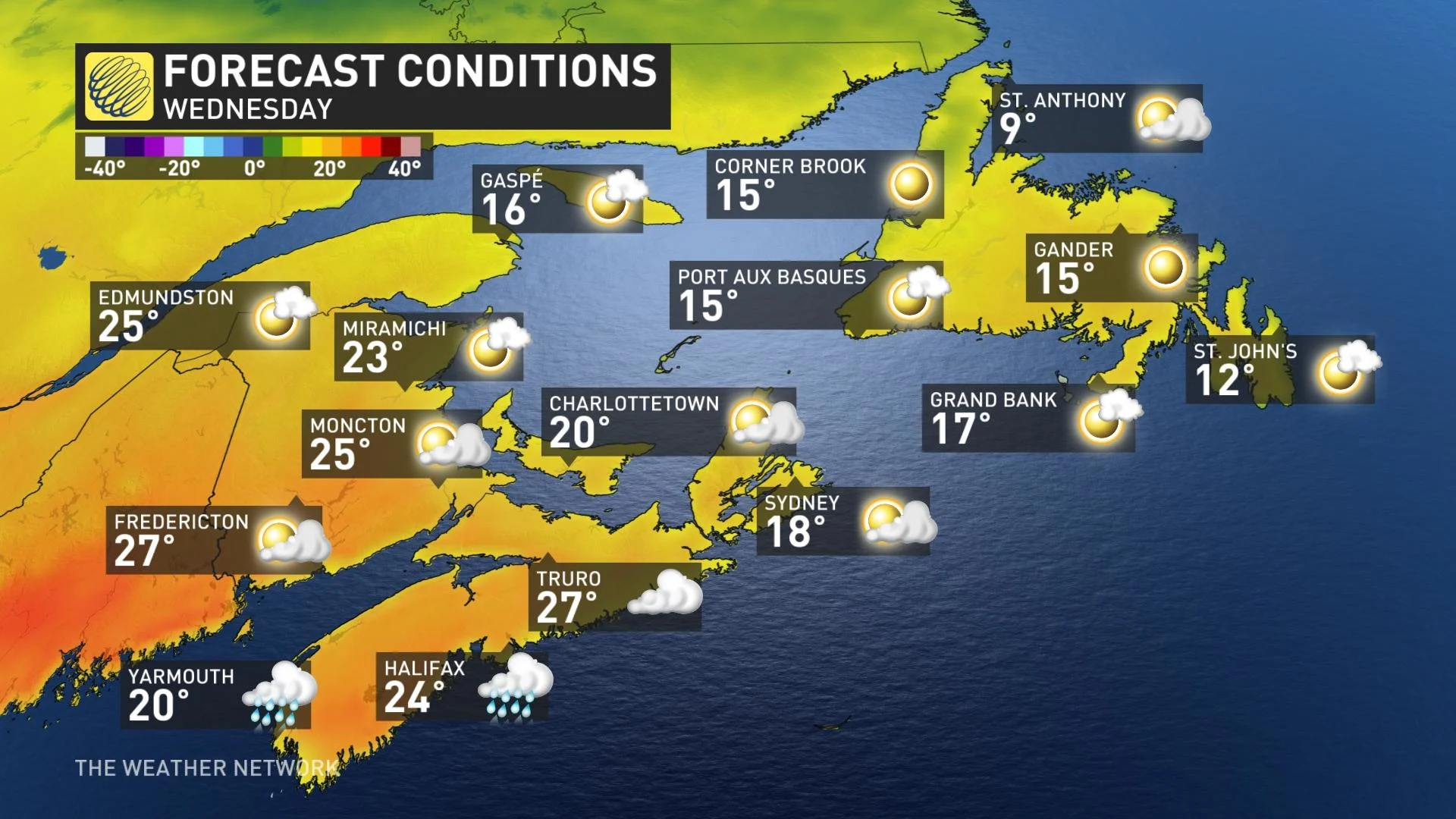
Daytime highs will still be warm, however, sitting in the mid-to-upper 20s for much of the Maritimes. Newfoundland will be significantly cooler.
As well, there may be some rumbles of thunder early Wednesday morning across Nova Scotia, but conditions will improve through the day in behind the cold front that sliced through. Mostly fair skies are expected across the region, though a cold rain woll accompany the cooldown in Newfoundland in the overnight hours.
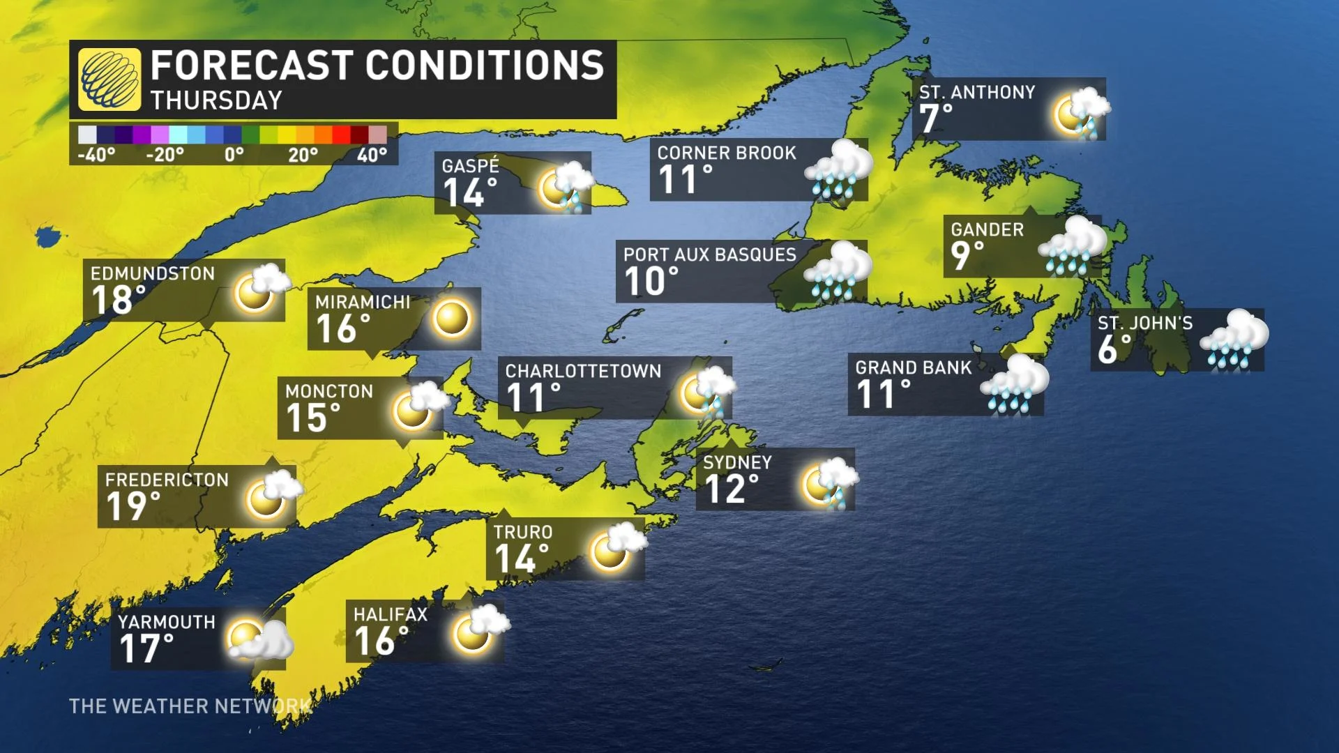
LATE WEEK: DRAMATIC TEMPERATURE REVERSAL
Thursday will see even cooler temperatures push in, as daytime highs collapse under the influence of a cold upper trough. A dramatic temperature reversal is expected for the region. Showers are possible for the eastern Maritimes, as well.
St. John's, and much of Newfoundland, will actually see daytime highs tumble to the mid-single digits by Thursday.
"We're watching a couple of strong systems that are expected to track well south of the region this weekend and early next week, but at this point it looks like the storm track will be too far south to have a major impact on the region," says Dr. Doug Gillham, a meteorologist at The Weather Network.
It'll also be a cool weekend across the region, but with near seasonal conditions expected by Sunday for the western Maritimes.
Warmer conditions will briefly attempt to spread back into the region for next week, but cooler weather looks to win out for the Maritimes.
"Newfoundland has a better chance to see a couple days of warmer weather," Gillham adds.
Be sure to check back for the latest updates on the temperature roller coaster across Atlantic Canada.